- Neighboring Countries - Equatorial Guinea, Cameroon, Republic of the Congo, Sao Tome Principe, Democratic Republic of the Congo
- Continent And Regions - Africa Map
- Other Gabon Maps - Gabon Map, Where is Gabon, Gabon Blank Map, Gabon Road Map, Gabon Rail Map, Gabon River Map, Gabon Cities Map, Gabon Flag
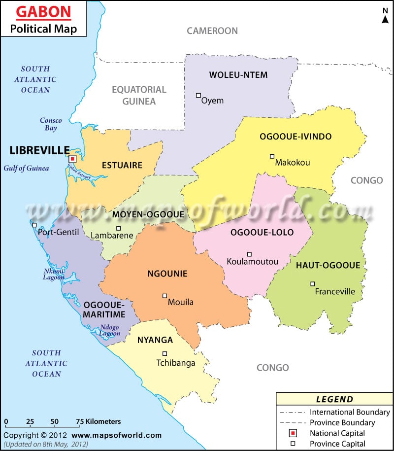
Gabon’s Political Map vividly shows the provinces, cities, provincial capitals, and the national and international boundaries of Gabon. The country lies between Equatorial Guinea and the Republic of the Congo and covers an area of about 267,667 sq km. Some of the major cities are Mekambo, Bogonville, Bitam, Sette Carna, and Akieni. Libreville is the capital city of Gabon.
Location of Gabon
Gabon, located in Western Africa is situated between Equatorial Guinea and the Republic of the Congo. It covers an area of 267,667 sq km and falls on the geographical coordinates of 1° South and 11° 45′ East. Gabon forms the border with the Atlantic Ocean at the Equator, Bight of Biafra, and Corisco Bay. Cameroon is located to the north of Gabon. Gabon’s Political Map provides in-depth knowledge about the provinces, cities, and provincial capitals of Gabon.
Cities of Gabon
Bitam, Minvol, Mitzic, Lara, Edoume, Mazingo, Mekambo, Ekata, Mayebout, Ovan, Booue, Ndjole, Befoun, Akok, Kougouleu, Ntoum, Kango, Owndo, Foulenzem, Yeno, Ndougou, Omboue, Iguela, Sette Carna, Yombi, Fougamou, Mimongo, Mbigou, Lebamba, Malinga, Ndende, Moabi, Bounda, Mayumba, Moulengui Biza, Lastouesville, Iboundji, Pana, Pkondja, Lekila, Akieni, Mounana, Moanda, Bakoumba, Boumango, Ngouoni, Bogonville and Lekoni are some of the major cities located across Gabon. All these cities are shown on the Gabon Political Map by black dots.
Libreville
Libreville is the national capital of Gabon and is located on the geographical coordinates of 0° 22′ 60″ North latitude and 9° 26′ 60″ East longitude. This place can be easily accessed from the cities and towns of Quaben, Ntchogo, Nomba, Adzebe, Lalala, Pointe Denis, and Atonda-Simba. Libreville Leon is the nearest airport to Libreville. The capital city can be easily identified on the Printable Map of Gabon by a red star.
Gabon Provinces
The provinces of Gabon along with their provincial capitals are mentioned below:
- Woleu-Ntem: Oyem
- Ogooue-Ivindo: makokou
- Estuaire
- Moyen Ogooue: Lambarene
- Ogooue-Lolo: Koulamoutou
- Haut-Ogooue: Franceville
- Ngounie: Mouille
- Ogooue-Maritime: Gentil
- Nyanga: Tchibanga
The provincial capitals are shown on the World Map Gabon by green squares.
The national boundary is marked with a red uneven line and the international boundary is shown with a black irregular line on the Gabon Map.
| Province | Population: 2003-12-31 census | Area(km.²) | Area(mi.²) | Capital |
|---|---|---|---|---|
| Estuaire | 662,028 | 20,740 | 8,008 | Libreville |
| Haut-Ogooue | 228,471 | 36,547 | 14,111 | Masuku |
| Moyen-Ogooue | 60,990 | 18,535 | 7,156 | Lambarene |
| Ngounie | 101,415 | 37,750 | 14,575 | Mouila |
| Nyanga | 50,297 | 21,285 | 8,218 | Tchibanga |
| Ogooue-Ivindo | 64,163 | 46,075 | 17,790 | Makokou |
| Ogooue-Lolo | 64,534 | 25,380 | 9,799 | Koulamoutou |
| Ogooue-Maritime | 128,774 | 22,890 | 8,838 | Port-Gentil |
| Woleu-Ntem | 157,013 | 38,465 | 14,851 | Oyem |
| 9 provinces | 1,517,685 | 267,667 | 103,346 |

 Gabon Independence Day