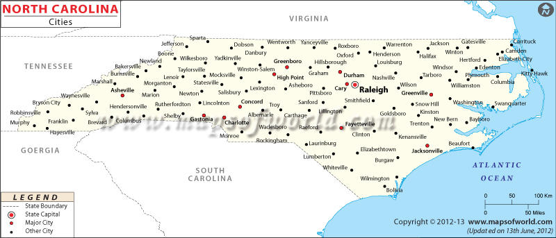
Map of North Carolina Cities

North Carolina Map with Cities
Discover the diverse cities of North Carolina with the North Carolina Map with Cities. This map provides you with the opportunity to explore the different cities within the state, making it easy to locate them on the map.
Cities in North Carolina
North Carolina has lots of cities, each with its own unique vibe. Some cities are super busy with lots happening, while others are quiet and nestled in nature. No matter if you like calm spots, outdoor adventures, or city exploration, North Carolina has a city that suits you! Whether you’re into nature, fun activities, or city living, you’ll discover something you really enjoy in North Carolina’s cities.
How Many Cities are in North Carolina
North Carolina has about 552 cities in total. Each city has its own unique things that make it special. Whether you like big busy cities or small comfy towns, you’ll find something you like in North Carolina’s cities. You can find where each city is on the North Carolina Map with Cities.
Largest Cities in North Carolina
The largest cities in North Carolina are like busy hubs full of opportunities to enjoy yourself and learn new stuff. Some of the biggest cities are Charlotte, Raleigh, Greensboro, Durham, and Winston-Salem. These cities have cool places to visit, schools where you can learn, and fun things to do. Whether you live there or you’re just visiting, these cities have lots of things to explore and find that can make you feel really happy, like you discovered something special.
Safest Cities in North Carolina
In North Carolina, there are cities that work hard to keep everyone safe and happy. Cities like Cary, Apex, Huntersville, and Wake Forest are famous for being really safe. They do a lot to prevent bad things from happening and to make sure everyone feels safe. These cities are good choices, especially if you want to live in a place where you feel secure, especially if you’re with your family or by yourself.
Best Cities to Live in North Carolina
North Carolina has awesome cities that make life enjoyable. Consider places like Cary, Asheville, Raleigh, Durham, and Chapel Hill. These cities offer jobs, excellent schools, and plenty of activities to enjoy. Whether you like spending time outdoors, want to keep learning, or trying new things, these cities have something special for you. They make sure you have a happy life with lots of things to have fun with.
Explore the Map of North Carolina Cities to delve deeper into the geographical locations of each city in North Carolina.
 Wall Maps