- Somalia Cities - Hargeisa, Mogadishu
- Somalia Regions - Ayl, Banaadir, Borama, Bosaso, Burao, Gedo, Hiiraan, Kismayo, Marka, Puntland, Somaliland
- Neighboring Countries - Kenya, Ethiopia, Djibouti
- Continent And Regions - Africa Map
- Other Somalia Maps - Somalia Map, Where is Somalia, Somalia Blank Map, Somalia Road Map, Somalia River Map, Somalia Political Map, Somalia Flag
Somalia is a country located in the Somali Peninsula in East Africa. It shares its boundary with Ethiopia to the west, the Gulf of Aden to the north, the Guardafui Channel and Somali Sea to the east and Kenya to the southwest.
Somalia Physical Features
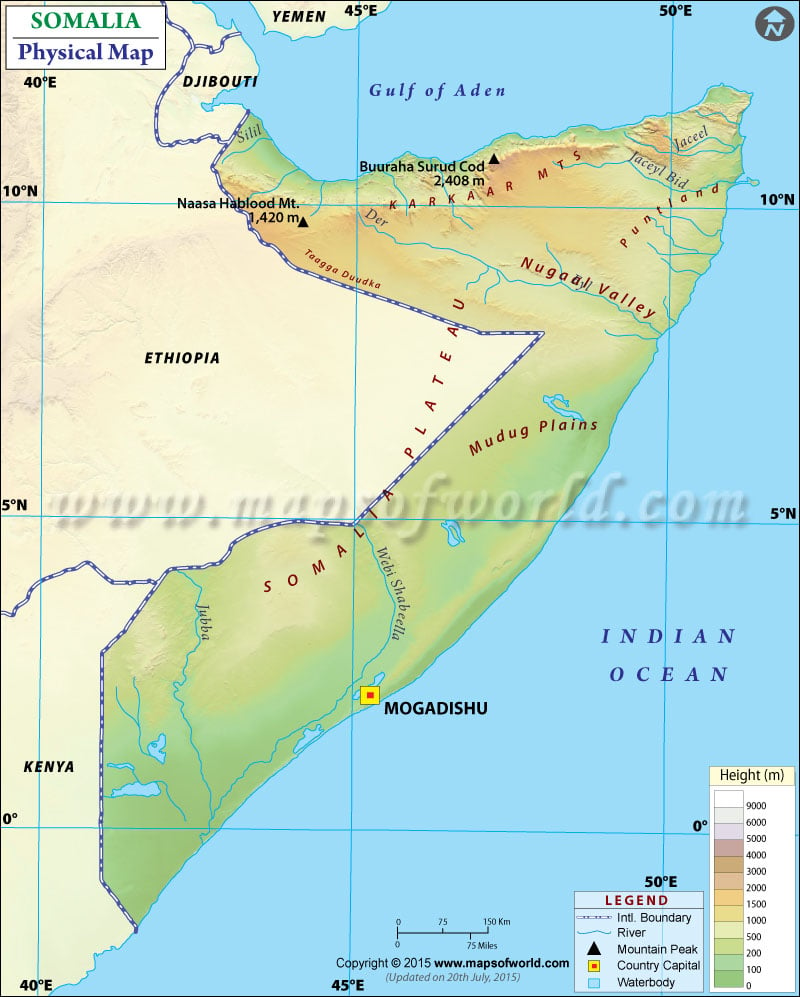
The country of Somalia has roughly been shaped “like a titled number seven”. The country is separated from Socotra by the Guardafui Channel and Seychelles by the Somali Sea. The coastline of Somalia is more than 3,333 kilometres in length, the longest of mainland Africa.
A map legend at the bottom gives all the signs, characters, graphics, and symbols used throughout the map. The Somalia Physical Map can be used for school work, presentation and other purposes. The land of Somalia is physio-graphically is limited. The topography of Somalia can be divided into
Plains along the Gulf of Aden and Nugaal Valley
In the north of the country, the semi-desert plain parallels the Gulf of Aden coast. The plains vary in width from twelve kilometres roughly in the west to approximately two kilometres in the east. In northwestern Somalia, along the Gulf of Aden, runs a narrow coastal plain called the Guban. The Guban Plain runs for about 150 miles between Seylac (Zeila) in the west and Berbera in the east. The plain broadens northward towards the port of Berbera. Another prominent relief feature of Somalia is Nugaal Valley, a long and broad valley located in northern Somalia. The Valley is bounded south by lid and north by sorl or Nugal Plateau.
Highlands and Plateaus
The Guban coastal plain is traversed by shallow and broad seasonal streams and gives way to the Ogo Highlands in the south. The Ogo Highlands, also called the Galgodon Highlands, is a region of broken mountains terrain in northern Somalia. The mountains range extends from the Cape Gwardafuy (Caseyr ) in the east to the Ethiopian border in the west. They have a height of about 6,500 feet(1980 m). The highest point of Somalia, Surud Cad, having an elevation of 7,900 feet (2,408 m), lies near Ceerigaabo (Erigavo) in three highlands. The highlands slope gradually to the Nugaaleed (Nogal) in the southeast and Hawd Plateau in the south. Hawd Plateau region covers the northern and eastern parts of the Somali Region of Ethiopia and the southern part of Somaliland. Another prominent feature is rugged Karkaar Mountain ranges, northward-facing cliffs of dissected highlands inland from the Gulf Coast. These ranges extend from the northwestern border of Ethiopia to the tip of the Horn of Africa in the east, where they end in sheer cliffs.
Important Rivers of Somalia
The permanent rivers in Somalia are Shabelle (Shebeli) and Jubba. These rivers originate in the Ethiopian Highlands and cut deeply into the plateaus before meandering through the alluvial plains toward the coast. Jubba river flows directly from north of Kismaayo into the Indian Ocean. In comparison, the Shabelle river flows into a large swamp before reaching the Juba River. Other rivers of the country are Nuggal and Todgdheer River.

 Somalia Demographics