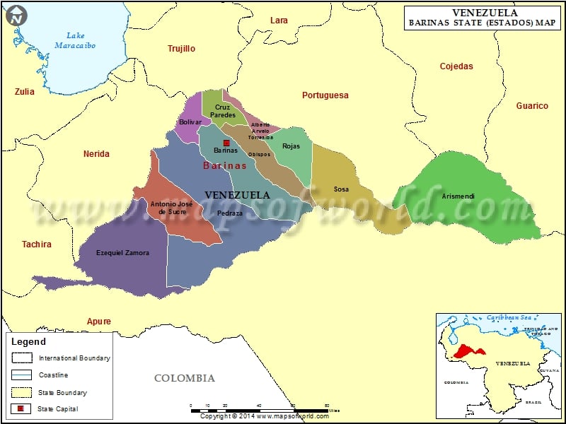
Barinas, one of the important states in Venezuela is situated in the sub-occidental region of Venezuela. Barinas of Venezuela covers an area of 35,200 square kilometers. The neighboring states of Barinas in Venezuela are Merida, Portuguesa, Trujillo and Cojedes in the North, Worries in the South, Guarico in the East and the states of Tachira and Merida in the West. More than 50% of the population of Venezuela resides in Barinas.
The topography of Barinas can be divided into mountains, hills and plain lands. The mountains of Barinas include Boilers with a height of 3900 meters; Bartolo at 3430 meters from the sea level; Guirigay at 3860 meters from the sea level; Don Pedro with a height of 3790 meters and the Tip of Masparro with a height of 3370 meters. The hilly region of Barinas is extremely fertile. It is also the most populated zone of the state.
Barinas has a great wealth of vegetation and helps in the growth of the economy of the country through its forest products. Vegetation of Barinas includes cambur, banana, sunflower, coffee cacao, sesame, caraotas, tobacco, cucurbitaceas, sideburn, melon, auyama, rice, name, and a lot more. Agriculture being the main occupation practiced by the Venezuelans, the significance of Barinas in the country’s economy cannot be overlooked.
Municipalities of Barinas State (Estado) |
| Municipality | Capital | Population | Area(km.²) |
|---|---|---|---|
| Alberto Arvelo Torrealba | Sabaneta | 32,183 | 769 |
| Andrés Eloy Blanco | El Cantón | 15,359 | 1,493 |
| Antonio José de Sucre | Socopo | 62,002 | 2,975 |
| Arismendi | Arismendi | 18,338 | 7,209 |
| Barinas | Barinas | 263,272 | 3,304 |
| Bolívar | Barinitas | 39,779 | 1,047 |
| Cruz Paredes | Barrancas | 20,574 | 778 |
| Ezequiel Zamora | Santa Bárbara | 42,104 | 4,042 |
| Obispos | Obispos | 25,774 | 1,753 |
| Pedraza | Ciudad Bolivia | 50,767 | 6,693 |
| Rojas | Libertad | 33,105 | 1,591 |
| Sosa | Ciudad De Nutrias | 21,251 | 3,546 |
