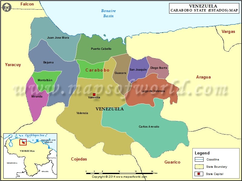
Carabobo is located in the central part of North Venezuela. It covers an area of 4,650 square kilometers. Carabobo consists of the mountainous range in Venezuela. Carabobo in Venezuela has Caribbean Sea in the north, Guarico and Cojedes to the south, Aragua to its east and Yaracuy in the west. The humid climate of Carabobo Venezuela allows a high growth of vegetation and dense forestation.
Carabobo, which is one of the important states in Venezuela, is the hub for industrial growth in the country. Agriculture is an important sector in the economy of Carabobo. The agricultural products include sugar maize, cotton, coffee, citruses, tobacco, cacao, cane, cambures, bananas and a lot more.
Carabobo has a rich historical value. The importance of Carabobo is emphasized by the fact that it had hosted the battle of Carabobo, which freed Venezuela from the Spanish rule. The place is also a very important tourist destination. Being considerably close to the national capital of Caracas, reaching Carabobo is never a problem. The deep valleys surrounding Carabobo, with their magnificent natural beauty, attract the tourists from far and wide.
Municipalities of Carabobo State (Estado) |
| Municipality | Capital | Population | Area(km.²) |
|---|---|---|---|
| Bejuma | Bejuma | 39,187 | 469 |
| Carlos Arvelo | Guigue | 124,344 | 835 |
| Diego Ibarra | Mariara | 94,852 | 79 |
| Guacara | Guacara | 142,227 | 165 |
| Juan José Mora | Morón | 56,458 | 453 |
| Libertador | Tocuyito | 146,507 | 558 |
| Los Guayos | Los Guayos | 130,345 | 64 |
| Miranda | Miranda | 23,368 | 161 |
| Montalbán | Montalban | 20,166 | 107 |
| Naguanagua | Naguanagua | 132,368 | 188 |
| Puerto Cabello | Puerto Cabello | 173,034 | 434 |
| San Diego | San Diego | 59,247 | 106 |
| San Joaquín | San Joaquín | 47,920 | 127 |
| Valencia | Valencia | 742,145 | 623 |
