Business Model
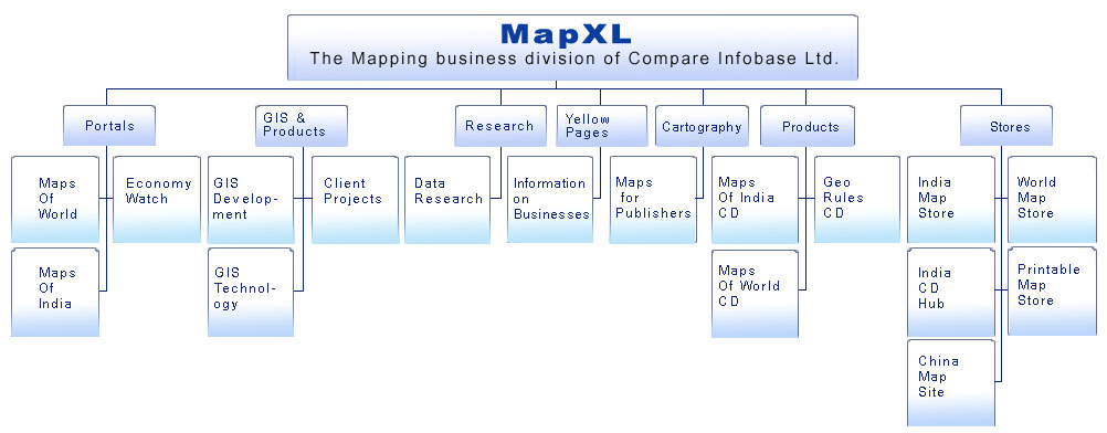
MapXL
MapXL, the business division of Compare Infobase Limited, aims to be a one-stop source of Maps, GIS and Cartographic solutions for the world. It provides ready-made and custom maps for publishing, data sets, GIS services and content development services. It also develops and markets its in-house products namely Maps of World CD, Maps of India CD, Geo Rules and Publishing Kits, which have been well received across the globe.
Portals
www.MapsofWorld.com:
Mapsofworld.com, set up in 2003, with a mere 80 pages, has come a long way to possess more than 30000 pages of authentic and valuable content. The site offers detailed maps of continents, countries and cities of the world and also latest information on events of international importance.
www.MapsofIndia.com:
MapsofIndia.com is the largest source of online maps on India. Launched in 1998, it is an established brand, servicing businesses, institutions and individuals across the globe. Its user friendliness and the huge collection of maps have earned it the reputation of being the number 1 mapping site on India.
www.EconomyWatch.com:
Economywatch.com is a unique portal with complete information on the World Economy with special focus on Indian Economy. The portal also has special coverage on sections like Insurance, Finance and Mortgage Industry in the World Market.
GIS & Projects
GIS Development
We prepare digitized maps of cities, countries, etc. Our vibrant team of GIS specialists has developed an interactive online application for maps for various places like Delhi, Gurgaon, Cyprus etc. These applications run on Map Server and can be optimized according to the user's requirements including placement of points, dynamically linking the maps with backend databases, putting slide shows, etc.
GIS Technology
Geo Coding: Turn simple lists of addresses and related data into rich geographical datasets by using our Geo coding services. We can assign geographic coordinates and other data records to all map features in a cost effective, fast and accurate manner.
Data Conversion: Convert paper maps, aerial photographs, satellite imagery or surveyed data and drawings of varying scales and quality into various digital formats using our data conversion services.
Image Processing Solutions: Our Image Processing Solutions involve converting high-resolution imagery into quality raster data products. This involves removing distortions by Geo rectification and Ortho rectification, creating mosaic maps, color balancing and image cutting ensuring high quality output in formats specified by the client.
Web based GIS Application development: Our team of PHP-map script, JAVA , Flash programmers along with Database administrators work to develop interactive online application for maps for various places and optimize them according to client/ user requirements.
Client Projects
We efficiently and effectively handle a number of client projects and provide 100% satisfaction to our valued clients in terms of quality, timely delivery and cost efficiency.
GIS Development
We prepare digitized maps of cities, countries, etc. Our vibrant team of GIS specialists has developed an interactive online application for maps for various places like Delhi, Gurgaon, Cyprus etc. These applications run on Map Server and can be optimized according to the user's requirements including placement of points, dynamically linking the maps with backend databases, putting slide shows, etc.
GIS Technology
Geo Coding:
Turn simple lists of addresses and related data into rich geographical datasets by using our Geo coding services. We can assign geographic coordinates and other data records to all map features in a cost effective, fast and accurate manner.
Data Conversion:
Convert paper maps, aerial photographs, satellite imagery or surveyed data and drawings of varying scales and quality into various digital formats using our data conversion services.
Image Processing Solutions:
Our Image Processing Solutions involve converting high-resolution imagery into quality raster data products. This involves removing distortions by Geo rectification and Ortho rectification, creating mosaic maps, color balancing and image cutting ensuring high quality output in formats specified by the client.
Web based GIS Application development:
Our team of PHP-map script, JAVA , Flash programmers along with Database administrators work to develop interactive online application for maps for various places and optimize them according to client/ user requirements.
Client Projects
We efficiently and effectively handle a number of client projects and provide 100% satisfaction to our valued clients in terms of quality, timely delivery and cost efficiency.
Research
Data Research-
The Research Center at Compare Infobase is a vibrant center for excellence, research and capacity development and endeavors to produce high quality research. The objective of the center is to create the biggest database both for India and the World and act as a catalyst of data source for making maps. The division has a dedicated team of 14 researchers who have a zeal and aptitude to put in their best.
Data documentation is done from varied sources including books, journals, government reports, publications, national and international reports, unpublished reports and official web sources.
Yellow Pages
Our Yellow Pages is a unique platform where all brands find their true market potential. This service combines Yellow pages with Maps where we aim to cover 2 million business locations from India plotted along with their addresses and phone numbers on detailed maps.
Yellow Pages
Information On Businesses
Our Yellow Pages is a unique platform where all brands find their true market potential. This service combines Yellow pages with Maps where we aim to cover 2 million business locations from India plotted along with their addresses and phone numbers on detailed maps.
Cartography
We offer customized map-making services by creating maps according to the specific requirements of clients including plotting of points and locations, highlighting areas/countries/zones, coloring patterns, sizes, styles, fonts, legends, company logos etc. One can avail these maps in different formats ranging from Adobe Illustrator and Freehand to JPG, GIF and TIFF formats. Some of our clients are Millennium House (Australia), Parragon Books Ltd (UK), Infomedia (India), (Readers Digest) India, etc.
Cartography
Maps For Publishers
We offer customized map-making services by creating maps according to the specific requirements of clients including plotting of points and locations, highlighting areas/countries/zones, coloring patterns, sizes, styles, fonts, legends, company logos etc. One can avail these maps in different formats ranging from Adobe Illustrator and Freehand to JPG, GIF and TIFF formats. Some of our clients are Millennium House (Australia), Parragon Books Ltd (UK), Infomedia (India), (Readers Digest) India, etc.
Products
Our Map CD products have printable maps, which can be used in presentations, projects, and for a variety of other purposes.
Maps of India CD:
Maps of India CD is an encyclopedia of India centric maps covering the country, its states, districts & cities in more than 5500 map images. The CD launched in 2001 is updated every year. Over the years the CD has established itself as a default source for maps on India and has more than 30,000 satisfied users across 50 countries and 750 cities of India.
Maps of World CD:
Maps of World CD is fabulous resource offering over a 1000 thematic maps of the world, countries and cities. The maps and information contained in the CD on a range of subjects and other additional tools like World Time Tool, World Air Distances, Distance Calculator, ISD Codes, Lat-Long Search, Info on Olympics, Tsunami & others makes it a valuable addition for executives, researchers, students & tourists.
All the maps in the CD are printable and can easily be used for presentations, projects and reports.
Geo Rules CD:
Geo Rules CD is a perfect referential resource for students, teachers, parents and everyone and anyone who wants to gain knowledge about the universe, the earth, its landforms, air, water, environment, etc. Its informative & concise lessons, diagrams, maps, animated graphics and photographs, learning games, exercises and quizzes make it an easy, informative and indispensable tool of learning.
Stores
India Map Store:
With over 7,000 satisfied customers, India Map Store is by far the largest online source for map products in India.
Launched in 1999, it is an exclusive, online store of India maps, globes, atlases, travel guides and CD products from leading publications across the world. Updated regularly, the store caters to the requests for specific India maps and travel products and ensures that they are delivered at the doorsteps of the client, in any part of the world.
World Map Store:
World Map Store is an online store of world maps, globes, atlases, travel guides, CD products, travel books, etc. It seeks to provide a single platform for the purchase and global shipment of hard copy maps, soft printable map images and other travel related products. Since 2004, this store has been providing quality published maps and travel products across the globe.
Printable Map Store:
Initiated in 2005, Printable Map Store is a one stop, innovative and customized mapping solution service site offering map images of continents, countries and cities of the world. All these maps are available in printable formats and can be easily customized as per the specific requirements of clients.
China Map Site:
China Map Site caters to the China centric maps requirements of clients. It has an exhaustive collection of all types of China City maps, Street maps, Travel maps, Wall Maps, globes, atlases and other related maps especially meant for anyone looking for detailed information on China.
India CD Hub
The main idea behind the launch of India CD Hub has been to provide a single platform for people living a fast paced life who are interested in purchasing interactive and informative CD products on a variety of topics. The range of CD products available with us is sure to address all your requirements, be it related to fashion, education, health, lifestyle, spirituality, travel, games, or anything else. Our Same Day Shipping Policy also guarantees speedy delivery of your order.
India Map Store:
With over 7,000 satisfied customers, India Map Store is by far the largest online source for map products in India.
Launched in 1999, it is an exclusive, online store of India maps, globes, atlases, travel guides and CD products from leading publications across the world. Updated regularly, the store caters to the requests for specific India maps and travel products and ensures that they are delivered at the doorsteps of the client, in any part of the world. World Map Store:
World Map Store is an online store of world maps, globes, atlases, travel guides, CD products, travel books, etc. It seeks to provide a single platform for the purchase and global shipment of hard copy maps, soft printable map images and other travel related products. Since 2004, this store has been providing quality published maps and travel products across the globe. Printable Map Store:
Initiated in 2005, Printable Map Store is a one stop, innovative and customized mapping solution service site offering map images of continents, countries and cities of the world. All these maps are available in printable formats and can be easily customized as per the specific requirements of clients. China Map Site :
China Map Site caters to the China centric maps requirements of clients. It has an exhaustive collection of all types of China City maps, Street maps, Travel maps, Wall Maps, globes, atlases and other related maps especially meant for anyone looking for detailed information on China. India CD Hub:
The main idea behind the launch of India CD Hub has been to provide a single platform for people living a fast paced life who are interested in purchasing interactive and informative CD products on a variety of topics. The range of CD products available with us is sure to address all your requirements, be it related to fashion, education, health, lifestyle, spirituality, travel, games, or anything else. Our Same Day Shipping Policy also guarantees speedy delivery of your order. |