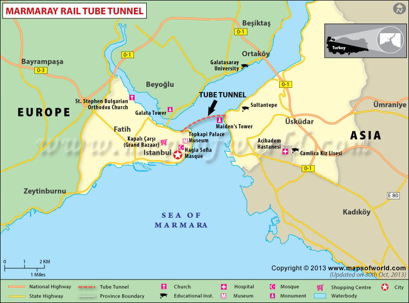
The Marmaray tunnel that connects Europe and Asia is a landmark in engineering. Opened on 29th October 2013 this undersea rail tunnel allows travelers to journey under the Bosporus Strait, which connects the Mediterranean Sea with the Black Sea. The tunnel is called Marmaray because it combines the name of the Sea of Marmara in the vicinity and “ray” which means rail in Turkish.
The complex project includes a 1.4-kilometer-long undersea tunnel which consists of a tube placed 60 meters under the sea. This is the deepest immersed tube tunnel in the world. Access to the undersea tunnel is through above-ground tunnels from Ayrilikcesme on the Asian side of Istanbul and Kazlicesme on the European side. The tunnel crossing will span 13.6 kilometers in all.
With the initial stage of the project being completed after the inauguration of the undersea tunnel, passengers can commute between Ayrilikcesme station (on the Asian side) and Kazlicesme station (on the European side), with halts at 3 underground stations en-route. Three underground stations have been constructed at Yenikapi, Sirkeci, and Uskudar. This stage can be crossed at a time of 19 minutes.
The next stage will involve the refurbishment of the above-ground lines between Yenikapi and Halkali on the European coast and Gebze and Ibrahimaga on the Asian coast. Another 37 stations will be reconstructed above ground. The tunnel project also includes the modernization of lines in a stretch beside the Sea of Marmara from Gebze on the coast of Asia to Halkali on the coast of Europe. This will result in the creation of a 76.3-kilometer-long high-capacity line between the towns of Gebze and Halkali. The journey from Gebze to Halkali is expected to take 104 minutes. This part of the project is likely to be completed by 2015.
The tunnel was formally inaugurated on 29th October 2013 in the presence of Abdullah Gul, the President of Turkey; Recep Tayyip Erdogan, the Prime Minister of Turkey; and Shinzo Abe, the Prime Minister of Japan. Also present were the Prime Minister of RomaniaVictor Ponta, and the President of Somalia Hassan Sheikh Mohamud.
As the route of the Marmaray tunnel lies along an earthquake-prone area, quite near to the North Anatolian Fault (18 km away) engineers had to take extra precautions to ensure the safety of the construction. The tunnel walls were constructed with waterproof concrete surrounded by a steel shell. The tunnel was also built with flexibility in the same way that skyscrapers are constructed to sway in the event of an earthquake. Flood precautions have also been built-in with floodgates at the joints of the tunnel to compartmentalize sections of the tunnel in the event of a flood. The concrete used in the construction of the tunnel is also fire-resistant and was coming from Norway.
Within the tunnel, there are two bi-directional tracks that can be used by both long-distance and commuter trains. Freight trains can also use the tunnel in off-peak hours. The connecting suburban lines are expected to ferry 75,000 passengers in each direction every hour. A total of 440 electric multiple unit cars will be used in the trains running through the tunnel, in the form of either five-car or ten-car trains. The cars will be produced by Hyundai Rotem in collaboration with Eurotem, a joint venture between Hyundai Rotem and Turkish rolling stock manufacturer Tuvasas. The construction of the tunnel was carried out by a Japanese-Turkish consortium led by Taisei Corporation.
The project began in 2004 and it was planned to be completed by April 2009, however, in the course of the digging of the tunnel, important archeological sites and artifacts were uncovered. An ancient fourth-century Harbour of Theodosius (earlier known as the Harbour of Eleutherios) was discovered, which included remains of the walls of the city of Constantinople and parts of ancient ships. Other excavations revealed fragments of pottery, human and horse skulls, and glass artifacts dating back to the Ottoman, Roman, Byzantine, and Hellenistic periods. This resulted in delays till the sites were excavated and the artifacts recovered.
Funding for the project has been provided by the European Investment Bank (EIB) and the Japan International Cooperation Agency (JICA). The entire cost of the project is estimated to cost around 2.5 billion US dollars. The archeological delays are estimated to have caused a cost-overrun of 500 million US dollars.
The tunnel is likely to have both great economic and cultural significance in its unification of Asia and Europe and has been compared to the Silk Road by the Turkish Press.
