- Continent And Regions - Africa Map
- Other Madagascar Maps - Madagascar Map, Where is Madagascar, Madagascar Blank Map, Madagascar Road Map, Madagascar Rail Map, Madagascar River Map, Madagascar Cities Map, Madagascar Political Map, Madagascar Flag
Madagascar is an island country in the Indian Ocean, 400 kilometres off the coast of East Africa, approximately across the Mozambique Channel.
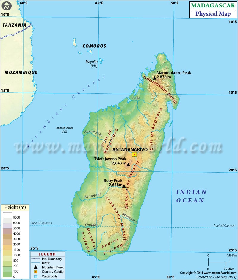
The country covers 592,800 square kilometres (228,900 sq mi) and is the second-largest island country. The Madagascar Physical map also highlights the capital of Madagascar, Antananarivo, in a red-yellow dot and is very useful for schoolwork, presentations and other purposes.
Madagascar Physical Features
This physical map of Madagascar depicts the latitudinal extent 12.S to 26.S and the longitudinal area between 43. E to 51.E. Based on dominant topographic features, the country is divided into the following geographic regions:
Central Highlands
The Central Highlands region extends from the Tsaratanana Massif in the North to the Ivakoany Massif in the south. This highland area, ranging from 800 m to 1800 m (2,625 to 5,906 ft), consists of various topographic features from eroded and rounded hills extinct volcanoes to peneplains, alluvial Plains and marshes. Highlands have Cliffs along the east coast, and they slope gently towards the west slope. The central highlands include Ankaratra Massif at an elevation of 2,643 m(8,671 ft) and Anjafy high plateau. The national capital Antananarivo with a height of 1,276 m (4,186 ft), is located in the northern portion of central highlands. Another prominent feature is a rift valley running NorthNorth to south, east of Antananarivo.
Tsaratanana Massif
Tsaratanana Massif is a volcanic mountain situated at the north end of the islands. The island’s highest point at 2,880 meters (9,449 feet) is Maromokotro in this region. Maromokotro is located inside the Tsaratanana Reserve in the island’s northern part. This massif separates the Tsaratanana region from the rest of the plateaus in the North.
East Coast
The east coast of Madagascar contains a narrow band of lowlands. The lowlands are formed from the sedimentation of alluvial soils and are about 50 kilometres wide. On Masoala Peninsula, NorthNorth of Baie d’ Antongil, the prominent feature is to the Island’s North. The coast also has Canal des Pangalanes, a lagoon formed naturally by the washing of sand by the Indian ocean currents on the island. It has been used as a fishing area and as a means of transportation.
West Coast and Southwest
This area is composed of sedimentary formations offering several harbours, of which one is Mahajanga. The west coast is more indented than the east coast. The west coast region in the past has served as an essential bridge between Madagascar and the outside world due to its deep bays and harbours. On the coast, alluvial plains are found between Toliara and Mahajanga regions.
The southwest part of the island shares its boundary with the Ivakoany Massif on the east and Isala Roiniforme Massif on the NorthNorth. The two regions along the island’s south coast are the Mahafaly Plateau and the desert region.
Important Rivers and Lakes in Madagascar
The major rivers that flow from the central highlands to the east coast are Mangoro and Mananara, and Maningory flows from Lake Alaotra. The other rivers flowing eastward into the Indian Ocean are Ivondro, Bemarivo, and Mananjary. The significant rivers on the west coast are Mahajamba, Mania, Mangoky and Betsiboka. Important lakes of the country are Alaotra, Lake Kinkony, Lake Itasy, and Lake Ihotry.
Physical Map of Neighbouring Countries
