- Neighboring Countries - United Arab Emirates, Saudi Arabia, Yemen
- Continent And Regions - Asia Map
- Other Oman Maps - Oman Map, Where is Oman, Oman Blank Map, Oman River Map, Oman Cities Map, Oman Flag
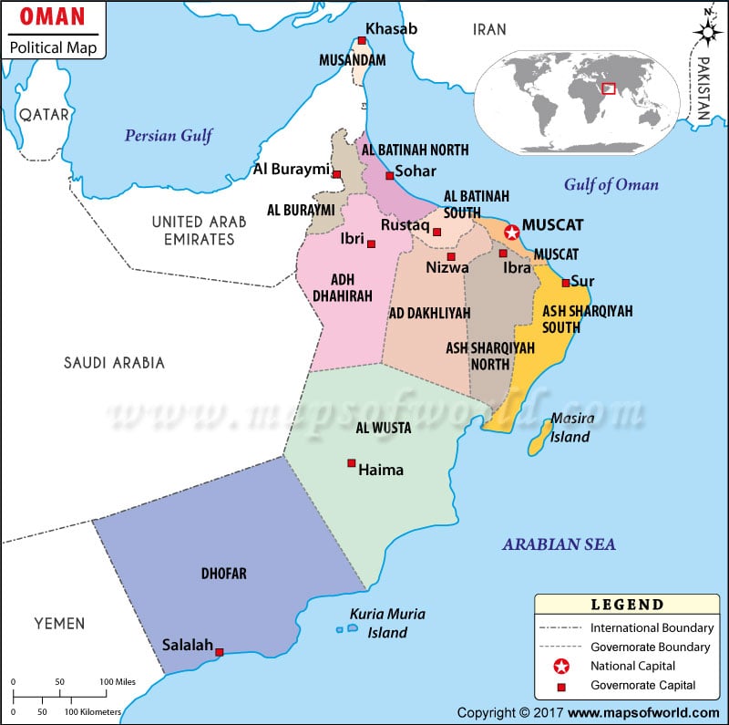
The Sultanate of Oman is an Arab country in south-west Asia covering a total area of 119,498 sq miles. The political map of the Sultanate of Oman highlights the major political divisions, major cities and towns, and the internal administrative divisions of the country.
As shown in the map,Oman is bordered by the United Arab Emirates to the north-west, Saudi Arabia to the west, and Yemen to the south-west. The Arabian Sea lies to the south-east of the nation while the Gulf of Oman bounds the country on the north-east.
The national capital, Muscat is shown on the map in red color enclosed in a square. Some of the well-known cities in Oman including Bahla, Buraimi, Ibra and Matrah are presented on the map as well.
The map also shows the various provincial boundaries of the nation.
| Governorate | Population | Area(km.²) | Area(mi.²) | Capital |
|---|---|---|---|---|
| Ad Dakhliyah | 326,651 | 31,900 | 12,300 | Nizwa |
| Adh Dhahirah | 151,664 | 44,000 | 17,000 | Ibri |
| Al Batinah North | 483,582 | 12,500 | 4,800 | Sohar |
| Al Batinah South | ||||
| Al Buraymi | 72,917 | Al Buraymi | ||
| Al Wusta | 42,111 | 79,700 | 30,800 | Haima |
| Ash Sharqiyah North | 146,449 | 36,800 | 14,200 | Ibra |
| Ash Sharqiyah South | ||||
| Dhofar | 249,729 | 99,300 | 38,300 | Salalah |
| Musandam | 31,425 | 1,800 | 700 | Khasab |
| Muscat | 775,878 | 3,500 | 1,400 | Muscat |
| 11 governorates | 2,773,479 | 309,500 | 119,500 |
| Region | Pop-2010 | Pop-2003 | Pop-1993 | Area(km.²) | Area(mi.²) | Capital |
|---|---|---|---|---|---|---|
| Ad Dakhliyah | 326,651 | 267,140 | 229,791 | 31,900 | 12,300 | Nizwa |
| Adh Dhahirah | 151,664 | 130,177 | 181,224 | 44,000 | 17,000 | Ibri |
| Al Batinah | 772,590 | 653,505 | 564,677 | 12,500 | 4,800 | Sohar, Rustaq |
| Al Buraymi | 72,917 | 76,838 | Al Buraymi | |||
| Al Wusta | 42,111 | 22,983 | 17,067 | 79,700 | 30,800 | Haima |
| Ash Sharqiyah | 350,514 | 313,761 | 258,344 | 36,800 | 14,200 | Sur |
| Dhofar | 249,729 | 215,960 | 189,094 | 99,300 | 38,300 | Salalah |
| Musandam | 31,425 | 28,378 | 28,727 | 1,800 | 700 | Khasab |
| Muscat | 775,878 | 632,073 | 549,150 | 3,500 | 1,400 | Muscat |
| 9 divisions | 2,773,479 | 2,340,815 | 2,018,074 | 309,500 | 119,500 |
 Wall Maps
 Facts about Oman