Great Slave Lake – Deepest Lake in North America
Great Slave Lake is a large, deep lake located in the Northwest Territories of Canada, and a popular site to fish in both the summer and the winter. It is the deepest lake in North America (ranking 9th worldwide), and the second largest in the Northwest Territories after the Great Bear Lake. The lake is named for the Slavey people, a First Nations indigenous tribe, who originally inhabited the lake around Great Slave Lake. The Slavey people established the town of Dettah and others. British explorers arrived in the area in 1771, and the lake was frozen. Communities around the lake include the towns of Yellowknife, Hay River, Hay River Reserve, Behchoko, Fort Resolution, Dettah, N’Dilo, and the small village of Lutselk’e, which is mostly populated by native Chipewyans. Yellowknife became the capital of the Northwest Territories after the gold discovery in the 1930s, and later became the country’s diamond capital. The lake’s tributaries are the Hay, Slave, and Taltson Rivers, and the Mackenzie River drains the lake into the Arctic Ocean. The lake was formed by glaciers, and still partially freezes over during winter. One ice road exists – the Dettah ice road, connecting Yellowknife to Dettah. There are islands within the lake and plenty of recreation opportunities. The East Arm of the lake is part of Thaydene Nene National Park, and to the south is Wood Buffalo National Park. Around the lake are many popular spots for fishing and ice fishing for a variety of fish species, including whitefish, trout, and perch.
Where is Great Slave Lake?
Great Slave Lake is located in the southern part of Canada’s Northwest Territories near the Alberta border. The lake communities are situated along Yellowknife Highway (Highway 3). The recently built Deh Cho Bridge crosses the Mackenzie River allowing vehicle access to Yellowknife during all seasons without the need for a ferry. The easiest way to travel around the Slave Lake is by car, but there are bus services to some of the towns around the lake. Another option is to take an ice fishing tour during winter. Some people opt for airplanes and bush planes to get access to other parts of the region that are without accessible roads.
Great Slave Lake Map
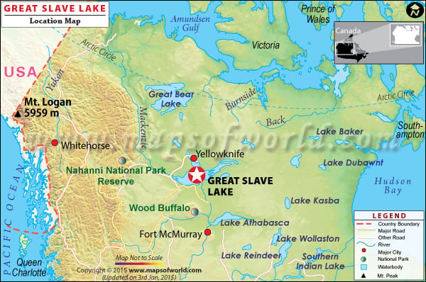
Location of Great slave lake in Canada
Great Slave Lake Facts
- This Lake is 614 meters deep (336 fathoms, 2,010 feet).
- This Lake measures 480 kilometers (300 miles) long, and ranges from 19 to 109 kilometers (12 to 68 miles) wide, with an area of 27,200 square kilometers (10,502 square miles).
- The volume of the Great Slave Lake ranges from 1,070 cubic kilometers (260 cubic miles) to 2,088 cubic kilometers (501 cubic miles).
- The Deh Cho Bridge is the longest jointless bridge on the continent.
When to Visit Great Slave Lake
As an outdoor recreation spot, Lake has something to offer year-round. Parts of the lake freeze over from November through May, and often into June, and it’s a popular spot for ice fishing. The ice road is also an interesting draw to the area. During the summer, fishing and other outdoor activities take place around the lake.
Nearby Attractions of Great Slave Lake
Nahanni National Park Reserve, Wood Buffalo National Park, Inuvik
Related : Lake Superior in North America | Rivers & Lakes in North America |