

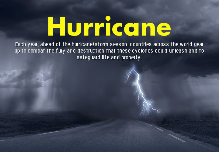

Each year, ahead of the hurricane/storm season, countries across the world gear up to combat the fury and destruction that these cyclones could unleash and to safeguard life and property. In 2015, the Atlantic hurricanes were rather tame due to a strong El Nino phenomenon, meteorologists say. Further east, however, the cyclonic storms in the Indian Ocean along with the monsoon have wrecked many Asian nations. Here are some of the major cyclones and storms of 2015.
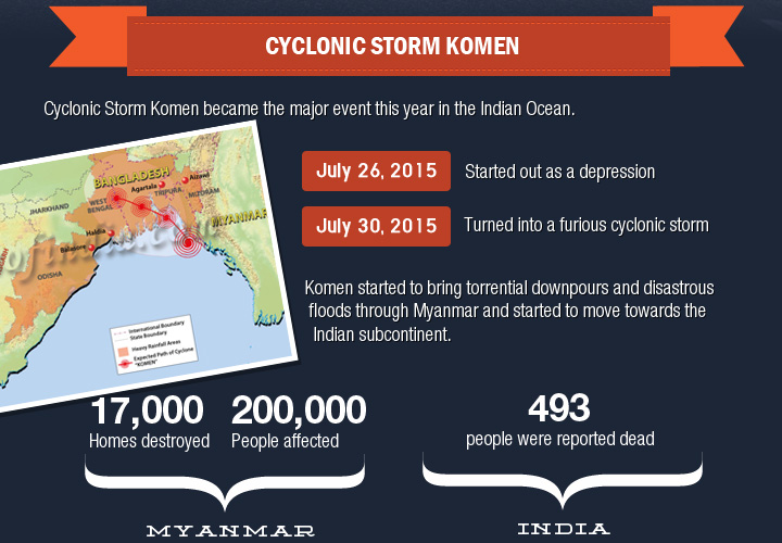
Cyclonic Storm Komen
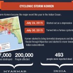
Cyclonic Storm Komen became the major event this year in the Indian Ocean front. What started out as a depression on July 26, 2015, soon turned out into a furious cyclonic storm by July 30. Komen started to bring torrential downpours and disastrous floods through Myanmar and started to move towards the Indian subcontinent. Before it moved away, Cyclonic Storm Komen was responsible for the destruction of 17,000 homes and affected about 200,000 people in Myanmar. The impact of the Cyclonic Storm Komen was rather large. Nepal, Vietnam, Bangladesh, eastern and central India, and even Pakistan faced severe rainfall. About 493 people were reported dead due to incidents related to this storm. In India, Komen lashed out over Odisha, West Bengal, and the North Eastern states causing widespread damage and bringing on flash floods that robbed many of their, lives and homes. Crops in these areas were also destroyed.
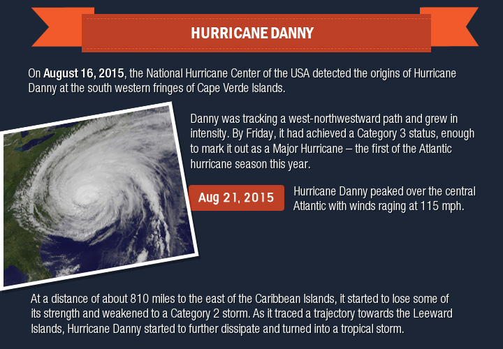
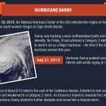
On August 16, 2015, the National Hurricane Center of the USA detected the origins of Hurricane Danny at the south western fringes of Cape Verde Islands. This disturbance developed along the north western coast of Africa and developed into an Atlantic Tropical Storm Danny within the next two days. Danny was tracking a west-northwestward path and grew in intensity. By Friday, it had achieved a Category 3 status, enough to mark it out as a Major Hurricane – the first of the Atlantic hurricane season this year. By the following day, August 21, Hurricane Danny peaked over the central Atlantic with winds raging at 115 mph. At a distance of about 810 miles to the east of the Caribbean Islands, it started to lose some of its strength and weakened to a Category 2 storm. As it traced a trajectory towards the Leeward Islands, Hurricane Danny started to further dissipate and turned into a tropical storm.
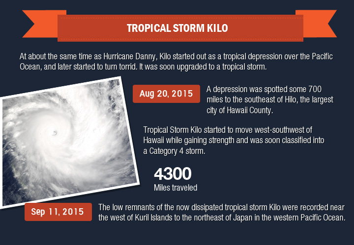
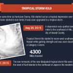
At about the same time as Hurricane Danny, Kilo started out as a tropical depression over the Pacific Ocean, and later started to turn torrid. It was soon upgraded to a tropical storm. On August 20, 2015, a depression was spotted some 700 miles to the southeast of Hilo, the largest city of Hawaii County. While Hawaii did not face its wrath as feared, Tropical Storm Kilo started to move west-southwest of Hawaii while gaining strength and was soon classified into a Category 4 storm. Tropical Storm Kilo lasted a good three weeks and traveled about 4300 miles. It brought heavy rainfall to Hawaii but did not cause much damage to the region. By September 11, the low remnants of the now dissipated tropical storm Kilo were recorded near the west of Kuril Islands to the northeast of Japan in the western Pacific Ocean.
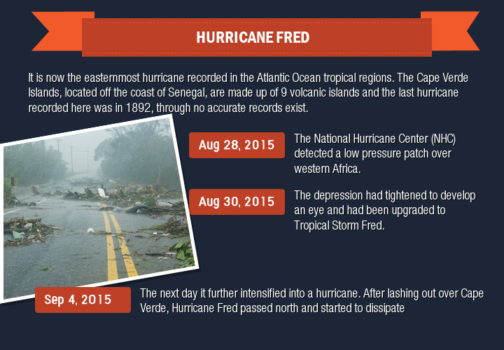
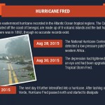
The Cape Verde archipelago seemed to be the hotspot for hurricane action this year. After the origins of Hurricane Danny in these parts, the second hurricane of the Atlantic Hurricane Season 2015, Hurricane Fred became the first in history to hit these islands. It is now the easternmost hurricane recorded in the Atlantic Ocean tropical regions. The Cape Verde Islands, located off the coast of Senegal, are made up of 9 volcanic islands and the last hurricane recorded here was in 1892, through no accurate records exist. Hurricane Fred recorded wind speeds of up to 85 mph. The National Hurricane Center (NHC) detected a low pressure patch over western Africa on August 28, 2015. This developed into a cyclone over the Guinea coastline in the next two days. By August 30, the depression had tightened to develop an eye and had been upgraded to Tropical Storm Fred. The next day it further intensified into a hurricane. After lashing out over Cape Verde, Hurricane Fred passed north and started to dissipate by September 4.
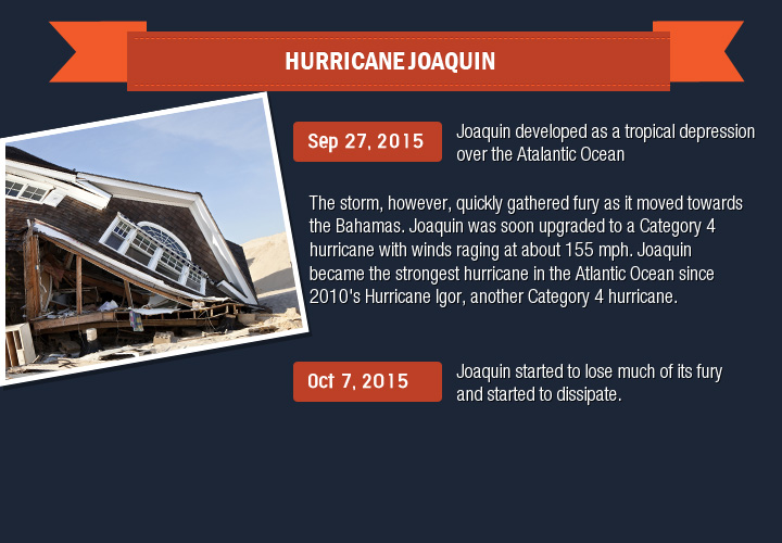
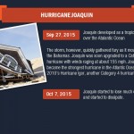
Joaquin developed as a tropical depression over the Atlantic Ocean on September 27, 2015. The storm, however, quickly gathered fury as it moved towards the Bahamas. Joaquin was soon upgraded to a Category 4 hurricane with winds raging at about 155 mph. Joaquin became the strongest hurricane in the Atlantic Ocean since 2010’s Hurricane Igor, another Category 4 hurricane. Torrential rainfall and floods battered the Bahamas with most of the houses on Crooked Island being destroyed. By October 7, Joaquin started to lose much of its fury and started to dissipate.
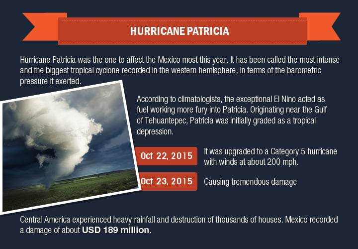
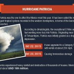
Developing in late October, Hurricane Patricia was the one to affect Mexico most this year. It has been called the most intense and the biggest tropical cyclone recorded in the western hemisphere, in terms of the barometric pressure it exerted. According to climatologists, the exceptional El Nino acted as fuel working more fury into Patricia. Originating near the near the Gulf of Tehuantepec, Patricia was initially graded as a tropical depression. Within a couple of days, by October 22, it was upgraded to a Category 5 hurricane with winds at about 200 mph. It made a landfall in western Mexico on October 23 causing tremendous damage. Central America experienced heavy rainfall and destruction of thousands of houses. Mexico recorded a damage of about USD 189 million. Despite the destruction, Mexico is certainly breathing a sigh of relief since Patricia made landfall near Cuixmala, the lesser populated regions of the country’s Pacific coast, thus missing the densely populated areas.