Mapsofworld Your Window to the World
Maps of World CD Ver 2.0
   Home
   CD Content
   CD Preview
   How to Order
   Secure Payment
   Shipment
   Return Policy
   About Us
   Contact Us
   View Cart
Site Price : US $50
Offer Price : US $40

Maps of World CD Version 2.0

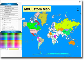
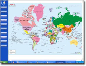
The Maps of World CD Ver 2.0 is a fabulous resource offering a significant variety of thematic maps of the world, countries and cities. The maps and information contained in the CD on subjects such as geography, polity, time zone, demography, agriculture, economy, international grouping, travel, sports, news and others makes it a valuable addition for office and home libraries. All the maps in the CD are printable and can easily be used for presentations, projects and reports.

The Maps of World CD contains:

MyCustom Map: The interactive map tool allows you to label, illustrate, fill colors, modify, and print the map as per your choice. Just fill in the data as per your mapping needs and get a personalized map. MyCustom Map�s inbuilt tools such as lines, icons, shapes, and paint basket make it a strong communicative medium.

World Maps: Browse thematic maps of the world � outline, polity, geography, demography, economy, earthquakes, international groupings and travel in this section. You can also find individual continent maps in this section.

Countries' Maps drawn from six continents:

  • Asia: View location, outline and political maps and flags of all the 43 Asian nations along with the country profiles in this segment.
  • Africa: Bring 54 African nations on your desktop with this section. Each country's location, outline and political maps are illustrated with its respective flag icon. 
  • Australia & Oceania: Featuring location maps and flags of the 14 countries from the region, .it also throws light on the economic and cultural profiles of most of these countries.
  • Europe: Find out the location and flags of 47 European countries in this segment. You can also get information on the profiles of most of the countries here.
  • North America: Ascertain the location of 23 countries that constitute this continent. Also find out about their flags and profiles in this section.
  • South America: Locate the 14 countries of South America  via maps and their respective flags. The profile of several of the countries can also be accessed.

USA Maps: Get complete information on USA, its states, counties, rivers, roads, tome zones, population, agriculture in this segment.

City Maps: Access maps of over 80 cities such as Amsterdam, Beijing, Frankfurt, Chicago, Hamburg, Tokyo, Sydney and others in this section. The printable maps illustrating roads, railways, highways, landmarks and places of interest are a great resource for travelers & tourists.

Sports World: This section integrates maps on the cricket, football and Olympics.

Useful Information: This section consists of informative facets on Olympics, Tsunami, Top Ten and events that made news.

Utility Tools

  • Latitude & Longitude Distance Calculator: You can track the latitudinal and longitudinal location of more than 200 countries and the cities of the world with this tool.
  • ISD Codes: You can search the ISD codes of 4, 400 cities in 225 countries either by the name of the country, city or simply inserting the ISD Code.
  • Country Profile: This tool helps you in providing information on the polity, geography, and history of the countries of the world. Select the country from the drop down list and get its quick overview.
  • World Air Distances: Ascertain the air distances in kms between important world cities by using 'one destination to other' or 'by one destination' option.
  • World Time: The utility tool helps in obtaining the exact timings of a country in reference to any given country. For Example, your selected location as 'Albania' where the present timing is 1hour, 1 minute and you want to get the actual timing in India the tool will fetch you the result time chart for India which will be five hours thirty minutes.
  • Elevation: This tool helps you to know the elevation of any country or city in the world. Just select Elevation from the list under utilities. Next, click on the icon shown along side to go to search option. You have two options, namely, to either Search by country or Search by city. You can alphabetically select the cities by clicking on the drop down menu.
  • Temperature: This tool helps you to know the temperature of any country or city in the world. Just select Temperature from the list under utilities. Next, click on the icon shown along side to go to search option. You have two options, namely, to either Search by country or Search by city. You can alphabetically select the cities by clicking on the drop down menu.
  • Precipitation: This is a useful tool that helps you to know the precipitation of any country or city in the world. Just select Precipitation from the list under utilities. Next, click on the icon shown along side to go to search option. You have two options, namely, to either Search by country or Search by city. You can alphabetically select the cities by clicking on the drop down menu.