|
 |
 |
 |
| TOP 10 EARTHQUAKES LAST MONTH |
|
|
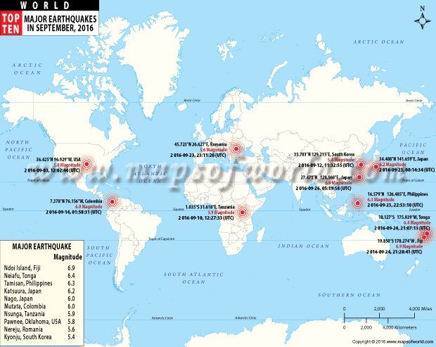
1) 6.9 MAGNITUDE
Location: Ndoi Island, Fiji
Coordinates: 19.850°S 178.274°W
Time: 21:28:41 UTC
Date: Sep 24, 2016
Deapth Below Surface: 596.3 km
Major Region: FIJI REGION
Damage/ casualities: There is a low likelihood of casualties and damage.
|
 |
2) 6.4 MAGNITUDE
Location: Neiafu, Tonga
Coordinates: 18.127°S 175.039°W
Time: 21:07:13 (UTC)
Date: Sep 24, 2016
Deapth Below Surface: 183.4 km
Major Region: TONGA
Damage/ casualities: There is a low likelihood of casualties and damage.
|
|
|
3) 6.3 MAGNITUDE
Location: Tamisan, Philippines
Coordinates: 6.579°N 126.485°E
Time: 22:53:10 UTC
Date: Sep 23, 2016
Deapth Below Surface: 65.0 km
Major Region: MINDANAO, PHILIPPINES
Damage/ casualities: Caused secondary hazards such as landslides
City: Ilangay
|
 |
4) 6.2 MAGNITUDE
Location: Katsuura, Japan
Coordinates: 34.488°N 141.659°E
Time: 00:14:34 UTC
Date: Sep 23, 2016
Deapth Below Surface: 10.0 km
Major Region: OFF THE EAST COAST OF HONSHU, JAPAN
Damage/ casualities: Caused secondary hazards such as landslides.
City: Naruto
|
|
|
5) 6.0 MAGNITUDE
Location: Nago, Japan
Coordinates: 27.471°N 128.560°E
Time: 05:19:58 UTC
Date: Sep 26, 2016
Deapth Below Surface:40.3 km
Major Region: RYUKYU ISLANDS, JAPAN
Damage/ casualities: NA
|
|
6) 6.0 MAGNITUDE
Location: Mutata, Colombia
Coordinates: 01:58:31 UTC
Time: 01:58:31 UTC
Date: Sep 14, 2016
Deapth Below Surface: 17.0 km
Major Region: NORTHERN COLOMBIA
Damage/ casualities: CCaused secondary hazards such as landslides and liquefaction
City: Mutata
|
|
|
7) 5.9 MAGNITUDE
Location: Nsunga, Tanzania
Coordinates: 1.035°S 31.618°E
Time: 12:27:33 UTC
Date: Sep 10, 2016
Deapth Below Surface: 40 km
Major Region: LAKE VICTORIA REGION, TANZANIA
Damage/ casualities: Caused secondary hazards such as landslides
City: Bukoba
|
|
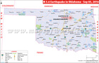
8) 5.8 MAGNITUDE
Location: Pawnee, Oklahoma
Coordinates: 36.425°N 96.929°W
Time: 12:02:44 UTC
Date: Sep 03, 2016
Deapth Below Surface: 5.6 km
Major Region: OKLAHOMA
Damage/ casualities: NA
City: Pawnee
|
|
|
9) 5.6 MAGNITUDE
Location: Nereju, Romania
Coordinates: 45.723°N 26.627°E
Time: 00:14:34 UTC
Date: Sep 23, 2016
Deapth Below Surface: 88.3 km
Major Region: ROMANIA
Damage/ casualities: Caused secondary hazards such as landslides.
City: Tamasi
|
|
10) 5.4 MAGNITUDE
Location: Kyonju, South Korea
Coordinates: 35.781°N 129.215°E
Time: 11:32:55 UTC
Date: Sep 12, 2016
Deapth Below Surface: 13.0 km
Major Region: SOUTH KOREA
Damage/ casualities: Caused secondary hazards such as landslides
City: Kyonju
|
|
 |
 |
|
|
 |
|
|
|
|