- Czech Republic Cities - Brno, Ceske Budejovice, Hradec Kralove, Jihlava, Karlovy Vary, Liberec, Olomouc, Ostrava, Pardubice, Plzen, Prague, Usti nad Labem, Zlin
- Czech Republic Regions - Cheb, Chrudim, Kadan, Kutna Hora, Liberec, Mlada Boleslav, Pribram, Rokycany, Trutnov, Usti nad Labem, Zdar nad Sazavou, Znojmo
- Neighboring Countries - Slovakia, Germany, Austria, Poland, Slovakia
- Continent And Regions - Europe Map
- Other Czech Republic Maps - Czech Republic Map, Where is Czech Republic, Czech Republic Blank Map, Czech Republic Road Map, Czech Republic Rail Map, Czech Republic River Map, Czech Republic Physical Map, Czech Republic Flag
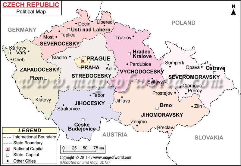
Czech Republic political map features important cities, the country capital and the state capitals. The state boundaries and the international boundaries are clearly demarcated for the convenience of the web surfers. The geographical coordinates of Czech Republic are 49° 45′ North latitude and 15° 30′ East longitude.
Prague is the country capital of Czech Republic. The geographical coordinates of the city is 50° 4′ 60” North latitude and 14° 28′ 0” East longitude. The city’s airports are served by many international airlines.
Czech Republic political map showcases the country’s location. Besides, the map also features the important cities of Czech Republic, the state boundaries with their capitals and the national capital. The map features different colors to mark the state boundaries of this landlocked country. Broken lines in the political map of Czech Republic are used to mark the state boundaries while broken lines with dots are used to mark the country’s international border. Czech Republic borders with Poland, Germany, Austria and Slovakia.
Geographical Coordinates and Location
The geographical coordinates of Czech Republic are 49° 45′ North latitude and 15° 30′ East longitude. The printable map of Czech Republic locates the country in the southeastern part of Germany in Central Europe. The total area of the country is 78, 866 square kilometer. The land area covered is 77, 276 square kilometer while 1,590 square kilometer is covered by water. The lowest point of the country is at Elbe River, which lies 115 meters above sea level while the highest point is Snezka situated at a height of 1, 602 meters above sea level.
State Boundaries with their Capitals
The white squares on the Czech Republic map denote the state capitals of the state boundaries. The map divides the country into eight states. The names of the states are typed in capital letters with bold fonts while the state capitals and cities are typed in normal fonts. The names of the states along with their capitals are listed below:
- Severocesky- Usti nad Labern
- Zapadocesky- Plzen
- Praha- Prague
- Jihocesky- Ceske Budejovice
- Jihomoravsky- Brno
- Severomoravsky- Ostrava
- Vychodocesky- Hradec Kralove
- Stredocesky
Important Cities of Czech Republic
The map of Czech Republic marks the important cities with the help of black dots so that they can be easily pointed. Some of the important cities are:
| Decin | Liberec | Most | Strakonice | Znojmo | Kladno | Opava |
| Teplice | Karlovy vary | Cheb | Breclav | Zlin | Pardubice | Preroy |
| Klatovy | Tabor | Trutnov | Jihlava | Prostejov | Sumperk | Oiomouc |
Country Capital of Czech Republic
Prague is the country capital of Czech Republic. The national capital is marked with a red dot within a square and falls in the Praha administrative division as pointed on the map. The geographical coordinates of the city are 50° 4′ 60” North latitude and 14° 28′ East longitude. The city stands at a height of 244 meters above sea level. The nearby cities are Liben, Stare Strasnice, Vrsovice, Kobylisy, Karlin, Holesovice, Kralovske Vinohrady and Zizkov. The main airports of the city are Kbely, Vodochody, Pribram and Ruzyne.
Regions of Czech Republic |
|---|
| Region | Chief town | Population – 2001 Census | Area(km.²) |
|---|---|---|---|
| Jihočesky | Česke Budějovice | 625,267 | 10,057 |
| Jihomoravsky | Brno | 1,127,718 | 7,065 |
| Karlovarsky | Karlovy Vary | 304,343 | 3,314 |
| Kralovehradecky | Hradec Kralove | 550,724 | 4,758 |
| Liberecky | Liberec | 428,184 | 3,163 |
| Moravskoslezsky | Ostrava | 1,269,467 | 5,535 |
| Olomoucky | Olomouc | 639,369 | 5,159 |
| Pardubicky | Pardubice | 508,281 | 4,519 |
| Plzeňsky | Plzeň | 550,688 | 7,561 |
| Praha | Praha | 1,169,106 | 496 |
| Středočesky | Praha | 1,122,473 | 11,016 |
| Ustecky | Usti nad Labem | 820,219 | 5,335 |
| Vysočina | Jihlava | 519,211 | 6,925 |
| Zlinsky | Zlin | 595,010 | 3,964 |
