|
|
A monthly news
|
Map
letter
on Maps, covering site
|
s of World
updates
& new products
|
|
|
|
|
|
April, the month of spring and Easter, heralds an undercurrent of resurgent energy for all. It marks the beginning of a new chapter and calls for concentrated action for development, progress and success. Looking forward to zestful times ahead. MapsofWorld.com, WorldMapStore.com and PrintableMapStore.com. welcome you to this edition of our Newsletter.
Warm Regards,
Anjali Thukral Dua
[email protected]
| |
|
|
|
|
|
|
|
|
|
|
|
|
|
|
|
|
|
|
|
|
|
|
|
|
|
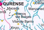
| Get
familiarized with Federation of Autonomous Communities of Spain
like Cantabria,
Castilla
Y Leon, Comunidad
Foral De Navarra, Galicia,
Pais
Vasco, and others.Each of these autonomous communities
is provided with its Political, Rail and Road maps
that provide detailed insight of the composition of Spain. |
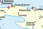
Find
out the countries that form a part of lively Caribbean archipelago.
This map accompanied with inset map images distinctly displays
Anguilla, Antigua and Barbuda, Aruba, Bahamas, Barbados, Bonaire,
British Virgin Islands, Cuba, Dominica, St. Lucia, St. Martin,
and other island countries. |
The segment especially created for the tennis aficionados lists
all the major international tennis events with their dates,
location and other associated details. The section also features
a world map illustrating the top ten 'Wimbledon Singles Title'
winning countries. New maps are incorporated in the section
on a regular basis.
|
|
|
 |
| WORLD MAP STORE PRODUCT REVIEWS |
|
|
 |
|
|
|
 |
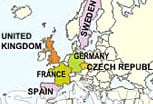
A Guide to Europe
The user friendly, travel guide offers profile of the several European countries accompanied with a detailed, folded political map of Europe. The map illustrates the various countries along with their significant cities. Indeed, a perfect tool to get acquainted with this part of the earth.
|
|
 |
Britannica
2006: Children's Encyclopedia
Help young minds find answers to their questions with this Encyclopedia. It contains two complete encyclopedias plus dictionary, thesaurus, world atlas, amazing multimedia, online games and interactive study guides. It is a complete reliable, trusted and convenient reference resource for children.
|
|
|
|
 |
Walking with the Buddha
Consisting of information on the history of Buddhism and sacred Buddhist sites in India, this handy guidebook has an interview with his Holiness the fourteenth Dalai Lama. It also features 200 specially commissioned color photographs and sketch maps of sacred Buddhist sites. |
|
 |
Shantou
Traffic Map
Planning your first visit to Shantou, China? Get the folded map of this city huddled in the Province of Guangdong. The map features the major roads, highways, routes, landmarks, places of interest, etc. Accompanied with a legend list, it will efficiently guide your way in the city.
|
|
|
|
|
| EXCLUSIVE OFFER OF THE MONTH |
|
|
|
|
|
|
|
|
|
Save US $ 20 or more on the purchase of Lonely Planet's USA Travel Guide and Berndtson & Berndtson maps of Washington D.C. and New York City.
 Discover the lively spirit of US ubiquitous in its Silicon Valley, Hollywood, Disneyland, Niagara Falls, the Grand Canyon, and Yosemite National Park in this Lonely Planet's Travel Guide. Consisting of fantastic travel write ups on the cosmopolitan cities, picturesque canyons, Rocky mountains and diverse communities of US plus over 130 maps, it is your ideal tour planner. The laminated, folded road maps of Washington DC and New York City maps from Berndtson & Berndtson cover in detail the road network and landmarks of these destinations. The maps will help you in your directions and routes in these cities.
Click here to avail the offer
|
|
|
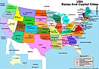
USA Political Map
|
|
PrintableMapStore.com brings to you the ready to use image of political map of USA. The political map shows the 50 Sates of USA along with their respective capital cities. The map also displays the water bodies around USA.
|
|
The ready to use map image is available in A4, A3, A2, A1 and A0 size. It can be customized in desired size, style and format on request. The map image can be ordered in print resolutions of 72 to 300 DPI and is useful for publishing and advertising, presentations, project reports, brochures, broadcasting purposes etc.
Please visit www.printablemapstore.com to browse and order map images.
|
|
|
| If you do not wish to recieve newsletters please click here
|

|
Compare Infobase (P) Ltd
C-62, Janak Community Center, Janakpuri, New Delhi-58(India)
Tel: +91-11-25542045, 41588013/14
Fax: +91-11-25547264
Email: [email protected]
We host With Serversindia.net Pvt. Ltd.
|
|
|

