- Neighboring Countries - Tunisia, Algeria, Niger, Chad, Sudan, Egypt
- Continent And Regions - Africa Map
- Other Libya Maps - Libya Map, Where is Libya, Libya Blank Map, Libya Road Map, Libya River Map, Libya Cities Map, Libya Physical Map, Libya Flag
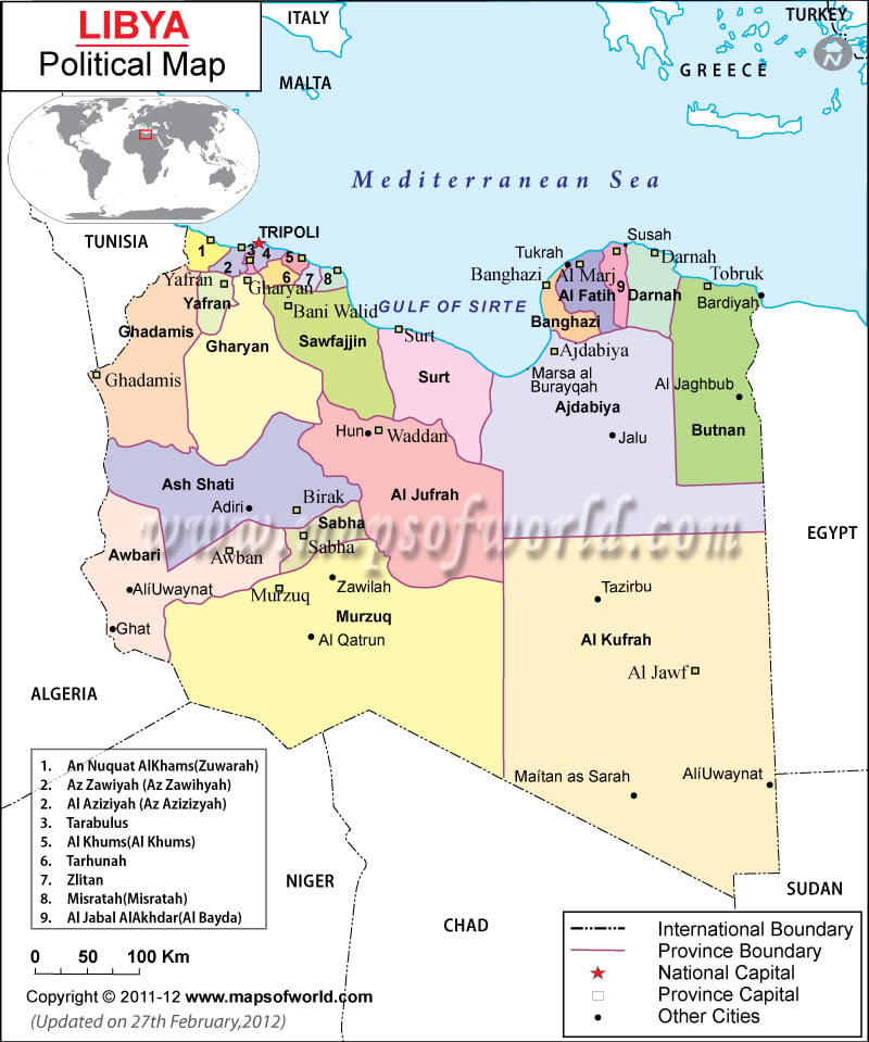
Libya political map showcases the country’s Baladiyat boundaries and their capitals. The country shares its borders with Niger, Chad, Sudan, Egypt, Algeria and Tunisia. The map of Libya shows northern part of the country bordering Mediterranean Sea. The geographical coordinates of the country are 25° North latitude and 17° East longitude. Tripoli is the capital of the country situated at an altitude of 6 meters above sea level.
National Capital of Libya
Tripoli is the national capital of Libya and can be easily pointed on the political map of Libya. The red star on the Libya map denotes the capital city. The geographical coordinates of the city are 32° 53′ 33” North latitude and 13° 10′ 48” East longitude. The city is situated 6 meters above sea level. The city can be easily accessed through three civilian airports, which are:
- Mitiga Airport
- Tripoli International Airport
- Sidi Salih Airport
Baladiyat Boundaries and Capitals
The Baladiyat boundaries are distinctly marked with violet lines as shown on the online political map of Libya. The capitals of the Baladiyats are marked with green squares on the map of Libya for the convenience of web browsers. Some of the Baladiyat capitals are listed below:
|
|
|
|
|
|
|
|
|
|
|
|
|
|
|
|
Geographical Coordinates of Libya
The geographical coordinates of Libya are 25° North latitude and 17° East longitude. The country is located in northern part of Africa bordering Mediterranean Sea, Egypt and Tunisia. The total land area covered is 1,759,540 square kilometers. 1,770 kilometers make up the coastline of the country. The highest point of the country is at Bikku Bitti situated at an altitude of 2,267 meters from sea level while the lowest point is at Sabkhat Ghuzayyil at -47 meters below sea level.
| District | Population | Capital |
|---|---|---|
| Al Butnan | 159,536 | Tobruk |
| Al Jabal al Akhdar | 203,156 | Al Bayda |
| Al Jabal al Gharbi | 304,159 | Gharyan |
| Al Jifarah | 453,198 | Aziziyah |
| Al Jufrah | 52,342 | Hun |
| Al Kufrah | 50,104 | Al Kufrah |
| Al Marj | 185,848 | Al Marj |
| Al Marqab | 432,202 | Al Khums |
| Al Wahat | 177,047 | Ajdabiya |
| An Nuqat al Khams | 287,662 | Zuwarah |
| Az Zawiyah | 290,993 | Az Zawiyah |
| Benghazi | 670,797 | Benghazi |
| Darnah | 163,351 | Darnah |
| Ghat | 23,518 | Ghat |
| Misratah | 550,938 | Misratah |
| Murzuq | 78,621 | Murzuq |
| Nalut | 93,224 | Nalut |
| Sabha | 212,694 | Sabha |
| Surt | 193,720 | Surt |
| Tripoli | 1,065,405 | Tripoli |
| Wadi al Hayat | 76,858 | Awbari |
| Wadi ash Shati’ | 78,532 | Adiri |
| 22 districts | 5,673,031 |

 Education in Libya, Libya Education