What is a sinkhole and where is the largest discovered?
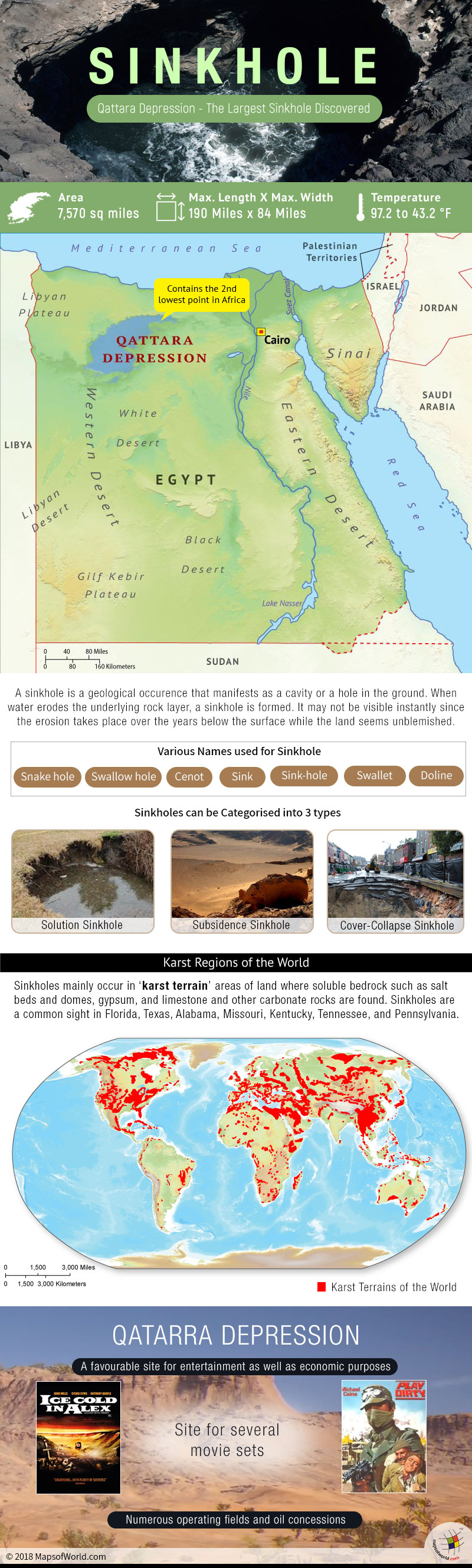
A sinkhole is a geological occurrence that manifests as a cavity or a hole in the ground. When water erodes the underlying rock layer, a sinkhole is formed. It may not be visible instantly since the erosion takes place over many years below the surface while the land seems unchanged.
Snake hole, swallow hole, cenote, sink, sink-hole, swallet or doline are the various names used for a sinkhole.
Prediction of sinkhole areas is difficult, but sinkholes mainly occur in what is known as ‘karst terrain’ areas of land where soluble bedrock such as salt beds and domes, gypsum, and limestone and other carbonate rocks are found. What we can infer from this is that dry areas are less prone to sinkholes. Sinkholes are a common sight in Florida, Texas, Alabama, Missouri, Kentucky, Tennessee, and Pennsylvania.
Though all sinkholes are formed by erosion, they can still be categorized into 3 types:
- Solution sinkholes occur when the bedrock has a very thin layer of soil over it. Water seeps through the rocks constantly, and over the years the rocks dissolve. When this happens, a sinkhole is formed.
- Subsidence sinkholes occur when the soil layer over the limestone bedrock is mainly comprised of sand. The limestone is eroded by water, and filters down into the openings of rock, causing the land surface to sink.
- Cover-collapse sinkholes are the scariest of all, they occur like a sudden attack. They occur where the covering sediments contain a significant amount of clay. Over time, the weight of the soil becomes too great and then they collapse. These sinkholes are striking as they are formed by underground erosion of the rock while the surface remains unblemished.
Not only natural, sinkholes are man-made too. These days construction of roads, and buildings, mining activities, old sewer pipes and aging sewer trigger urban sinkholes.
The largest sinkhole
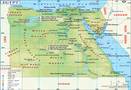
The largest sinkhole is The Qattara Depressions, lying in the north-west of Egypt in the Matruh Governorate and is part of the Western Desert. At an altitude of 133 meters (436 ft) below sea level, the Qattara Depression contains the second lowest point in Africa. It covers about 7,570 square mile area, with a maximum length of 190 miles, and a maximum width of 84 miles.
The average daily temperature during summer and winter months is 97.2 to 43.2 °F (36.2 to 6.2 °C). The Qattara Depressions witnesses an annual precipitation between 25 and 50 mm on the northern rim to less than 25 mm in the south of the depression.
Interestingly, it is a favorable site for entertainment as well as economic purposes. Sets of several films including Ice Cold in Alex (1958) and Play Dirty (1969) have been set here. Numerous operating fields and oil concessions prevail in the Qattara Depression.
Other prominent sinkholes across the world:
The 2010 Guatemala City sinkhole was a disaster in which an area of approximately 65 ft (20 m) across and 300 ft (90 m) deep.
Devil’s Sinkhole State Natural Area is a natural bat habitat near the city of Rocksprings in Edwards County in the U.S. state of Texas.
Akhayat sinkhole is in Mersin Province, Turkey. Its dimensions are about 150 m (490 f) in diameter with a maximum depth of 70 m (230 ft).
Bayou Corne sinkhole – Assumption Parish, Louisiana. About 25 acres in area and 750 ft (230 m) deep.
Devil’s Millhopper – Gainesville, Florida. 120 ft (37 m) deep, 500 ft (150 m) wide.
Giant crater sinkhole in Florida opened up in May 1981 was 350ft wide and 75ft deep.
Fukuoka in Japan witnessed a 30m by 27m sinkhole, which was 15 m deep.
The 2018 New Zealand sinkhole has is estimated to be 656 feet (200 meters) long and about 65 feet (20 meters) deep.
Related Maps: