What are the Key Facts of Uzbekistan?
|
Official Name |
Republic of Uzbekistan |
|
Continent |
Asia |
|
Capital |
Tashkent |
|
Largest City |
Tashkent |
|
Coordinates |
41.000000, 64.000000 |
|
Area |
173,351 sq. mi ( 448,978 sq. km) |
|
Land Boundaries |
4,283 mi ( 6,893 km) |
|
Coastline |
0 mi ( 0 km) landlocked |
|
Currency |
Uzbek som (UZS) |
|
Neighboring Countries |
Kyrgyzstan, Tajikistan, Afghanistan, Turkmenistan, Kazakhstan |
|
Population |
32,768,725 (2019 est.) |
|
Official Languages |
Uzbek |
|
Major Religion |
Islam |
|
National Day |
1 September (Independence Day) |
|
National Anthem |
“O’zbekiston Respublikasining Davlat Madhiyasi” |
|
Form of Government |
Unitary presidential constitutional republic; authoritarian state |
|
President |
Shavkat Mirziyoyev |
|
Prime Minister |
Abdulla Aripov |
|
GDP per capita (PPP) |
$ 7,020.3 (World Bank, 2018) |
|
GDP per capita (nominal) |
$ 1,532.4 (World Bank, 2018) |
|
HDI |
0.71 (2017), Rank: 105 |
|
Literacy Rate (%) |
99.99 (UNESCO, 2016) |
|
Space Agency |
Uzbek State Space Research Agency (UzbekCosmos) |
|
Military Expenditure Ranking |
NA (SIPRI, 2017) |
|
No. of Olympic Medals |
31 (as of 2018) |
|
Driving Side |
right |
|
Calling Code |
+998 |
|
Time Zone |
UTC+5 (UZT) |
|
Internet TLD |
.uz |
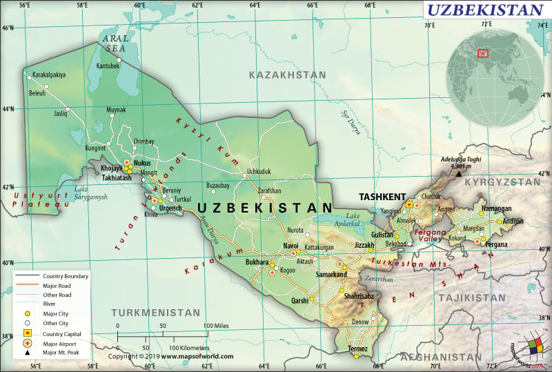
Where is Uzbekistan?
Uzbekistan is a Central Asian country that is located in the south of Kazakhstan and north of Turkmenistan.
What is the Geography of Uzbekistan?
The total area of Uzbekistan is 448,978 sq. km (173,351 sq. mi), out of which 425,400 sq. km (164,248 sq. mi) is land area and 22,000 sq. km (8,494 sq. mi) is water area. The country has a 6,893 km (4,283 mi) long land boundary.
The land boundary is shared with Kazakhstan (2,330km or 1,448mi) to the north, Turkmenistan (1,793km or 1,114mi) to the southwest, Kyrgyzstan (1,314km or 816mi) to the northeast, Tajikistan (1,312km or 815mi) to the southeast, and Afghanistan (144km or 89mi) to the south.
Uzbekistan is a doubly landlocked country. It has no coastline. This country includes Aral Sea’s southern portion having a 420km (261mi) shoreline.
Around 80% of Uzbekistan’s landform is sandy and scrubby desert. It includes the massive Kyzyl Kum. In the northeast and southeast regions of the Uzbekistan Mountains can be found, which are the lower mountains and foothills of the Himalayas’ extension, the Tian Shan Range.
The Fergana Valley has the most desirable climate and agricultural land in entire western Asia. This valley is located between the mountain ranges in the northeast and southeast parts of the country. The vast lowlands (including Amu Darya River valley, Ara Sea’s southern half and the Ustyurt Plateau) dominate the landscape in the far west.
The major mountains of Uzbekistan are Khazret Sultan, Mount Adelung, Mount Beshtor, Greater Chimgan, etc. Adelunga Toghi is the highest elevation point at 4,301 m (14,111 ft). The lowest elevation point is Sariqamish Kuli at -12 m (-39 ft). The Amu Darya and the Syr Darya are the major rivers. Lake Sarykamish and Lake Ayddrkul are the major lakes.
There are two types of climates in Uzbekistan: arid continental and continental. The arid continental climate is there in the central-western regions, where the vast steppe plains can be found. Continental climate (having a moderately rainy climate and snowy winter) is there in the eastern region, dominated by hills and mountains.
The northern parts remain cold during winter. The average temperature in the month of January in the northernmost parts (including the Arar Sea and the Kyzyl Kum Desert’s northern parts) revolves around -5 °C (23 °F).
The Ancient Silk Road’s central cities including Tashkent, Bukhara, and Samarkand usually have slightly above freezing temperatures (0 °C or 32 °F) in January. In the extreme south, the temperature goes up to 5 °C (41 °F).
The month of summer usually remains hot. While the southern parts get 30 °C (86 °F) temperature, the northern parts get 26/27 °C (79/81 °F) temperature in July. With the rise in altitude in the mountains, the temperature drops.
Cold air masses from Siberia blow in the northwestern parts of Uzbekistan. These air masses also blow in the center-south. The warmer air masses blowing from the south alternate with the cold Siberian air masses. When these strong air masses clash, strong winds are formed.
The western part of Uzbekistan is characterized by desert and semi-desert climates, where precipitation is a typical phenomenon. The rate of precipitation is higher in the central-eastern parts, especially in the semi-arid steppe level. The more exposed slopes of the mountains get more rainfall. Summer usually gets lots of sunlight and is the driest season.
What is the Economy of Uzbekistan?
Uzbekistan has maintained a sort of planned economy but is gradually transitioning to a market-based economy. The country has adopted a 2019–21 “Reform Roadmap” with the help of the World Bank in January 2019, which outlines a comprehensive plan of achieving economic/social goals over the medium term. In 2018, the economy grew at a rate of 5.133% to reach US$50.5 billion.
The main export items of the Uzbekistan economy are gold, refined copper, ethylene polymers, non-retail pure cotton earn, petroleum gas, etc. The major import items of the country are vehicle parts, coated flat-rolled iron, refined petroleum, vehicle parts, sawn wood, packaged medicaments, and many more. The country had a negative trade balance of US$2.84 billion in 2017. While it exported US$8.38 billion worth of goods, the value of imports was $11.2 billion.
The National Scientific Center for Employment under the Employment Ministry of Uzbekistan has found that the country had a 9.3% rate of unemployment in 2018 (which was 5.8% in 2017). Strong growth in domestic investment (despite disappointing agricultural production) helped to decrease the poverty rate marginally from 11.9% in 2017 to 11.5% in 2018.
What is the Transportation System of Uzbekistan?
Uzbekistan has 86,496 km (53,746 mi) long roadways, out of which 75,511 km (46,920 mi) is paved and 10,985 km (6,826 mi) is unpaved. The country has a considerably long railway network (broad gauge), which is 4,642 km (2,884 mi) long. 1,100 km (684 mi) long waterways are also present. Termiz (Amu Darya) is the main river port of Uzbekistan. There are 53 airports in the country, out of which 33 have paved runways and 20 have unpaved runways.
What International Organizations is Uzbekistan part of?
UN, IMF, UNESCO, ADB, CICA, CIS, EAPC, EBRD, ECO, FAO, IAEA, IBRD, ICAO, ICCt, ICRM, IDA, IDB, IFAD, IFC, IFRCS, ILO, Interpol, IOC, ISO, ITSO, ITU, MIGA, NAM, OIC, OPCW, OSCE, PFP, SCO, UNCTAD, UNIDO, UNWTO, UPU, WCO, WHO, WIPO, WMO, ICC (national committees), WFTU (NGOs), WTO (observer), UN Security Council (temporary)

