What are the Key Facts of Nebraska?

|
State |
Nebraska |
|
State Capital |
Lincoln |
|
Largest City |
Omaha |
|
Coordinates |
41.5°N 100°W |
|
Nickname(s) |
“Cornhusker State” |
|
Postal Abbreviation |
NE |
|
Area |
77,358 sq. mi (200,356 sq. km) |
|
Highest Point |
Panorama Point, 5,424 ft (1,654 m) |
|
Number of Counties |
93 |
|
Neighboring States |
South Dakota, Iowa, Missouri, Kansas, Colorado, Wyoming |
|
Population |
1,929,268 (2018) |
|
Date of Entering the Union |
March 1, 1867 |
|
State Anthem |
“Beautiful Nebraska” |
|
Governor |
Pete Ricketts (Republican) |
|
Lieutenant Governor |
Mike Foley (Republican) |
|
U.S. Senators |
Deb Fischer (Republican), Ben Sasse (Republican) |
|
U.S. House Delegation |
Jeff Fortenberry (Republican), Don Bacon (Republican), Adrian Smith (Republican) |
|
GDP (Millions of Dollars) |
123978 |
|
Demonym |
Nebraskan |
|
Time Zones |
most of state UTC−06:00 (Central), Summer (DST) UTC−05:00 (CDT); Panhandle UTC−07:00 (Mountain), Summer (DST) UTC−06:00 (MDT) |
Where is Nebraska?
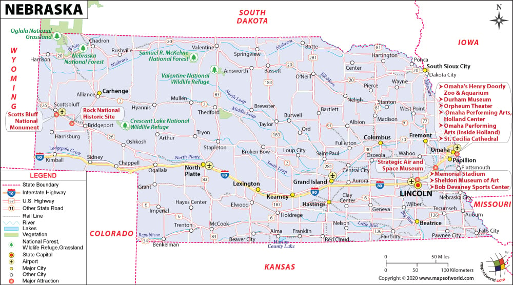
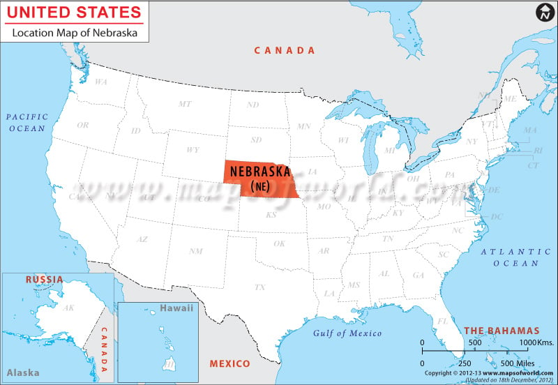
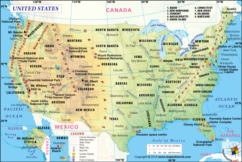
Nebraska is located in the Midwestern USA as well as the Great Plains. The state is landlocked between six US states. It shares its border with Wyoming to the west, Colorado to the southwest, Kansas to the south, Missouri to the southeast, Iowa to the east, and South Dakota to the north.
What is the Geography of Nebraska?
Nebraska is spread across a total area of 77,358 sq. mi (200,356 sq. km), making it the 16th largest state out of the 50 US states. The land area is spread across 76,874 sq. mi (199,099 sq. km), and the water area is spread across 481 sq. mi (1,247 sq. km). Nebraska is around 430 mi (692 km) long and 210 mi (338 km) wide. Water bodies occupy just 0.7% of the total area. There is no coastline or shoreline.
Some of the longest rivers in the state are Missouri River, North Platte River, White River, Niobrara River, Republican River, South Platte River, Big Blue River, Platte River, and the Elkhorn River. The major lakes in Nebraska are Lake McConaughy, Lewis and Clark Lake, Harlan County Lake, Calamus Reservoir, Sutherland Reservoir, Merritt Reservoir, Sherman Reservoir, Lake Minatare, Branched Oak Lake, Lake Wanahoo, Carter Lake, Buckskin Hills Lake, and Fremont Lakes.
The mean elevation of Nebraska is 2,600 ft (792.5 m) above sea level. Panorama Point is the highest point in the state at 5,424 ft (1,653.2 m) above sea level, and the Missouri River in southeastern Richardson County is the lowest elevation point at 840 ft (256 m) above sea level.
The major mountains in Nebraska are Panorama Point, Hogback Mountain, Mount Edna, Lovers Leap Butte, Table Top Mountain, Lone Pine Butte, Pants Butte, Eagle Nest, South Bluff, and The Horseshoe.
The landforms mainly include plains. In the eastern part of Nebraska, the Dissected Till Plains are located. As you move to the north-central and northwest parts, the land rises to the Great Plains. One-fifth of eastern Nebraska is covered by the Dissected Till Plains, consisting of rolling hills crisscrossed by rivers and streams. The Dissected Till Plains have fertile soil, which is used for farming soybeans, corn, sorghum grain, and other crops.
Loess Hills (consisting of buff to yellowish-brown loamy dust) are found in the northern part. Winds distribute Loess across the northern part of Nebraska. To the west of the Dissected Till Plains, the Great Plains of Nebraska is located. The central and south-central regions of the Great Plains are covered by Loess, characterized by rough and hilly terrain.
The southeastern region of Nebraska has a relatively flat area, a 7,000 sq. mi (18,129.9 sq. km) area known as the Loess Plains (also called Rainwater Basin or the Rainbasin). This landform is interspersed with wetlands and lakes. Intense farming takes place in this landscape.
Sand dunes are spread across 20,000 sq. mi (51,799.8 sq. km) in central Nebraska (north of the Platte River). In North America, it is the largest area of sand dunes. The wind has blown fine sand to form this hill of sands. Grass holds the sand together to form Sand Hills.
The High Plains are situated to the west and north of the Sand Hills. In the west, the land in the High Plains rises up to more than 1 mi (1.6 km) above sea level along the Wyoming border. Rougher regions in this landform are used mainly for grazing cattle. Evergreen trees covered the picturesque Wildcat and Pine Ridges. The highest elevation point is located in southwestern Kimball County.
A small area of Badlands is located in Nebraska’s northwestern corner. The sandstone and clay have been sculpted by nature with the help of wind and water to form beautiful but strange-looking natural formations. Steep hills, revealing sandstone and siltstone structures including mushroom-shaped pedestals, are laid bare by winds. In the Nebraska Badlands, Toadstool Park of Oglala National Grasslands has come up as a popular tourist attraction.
What is the Climate of Nebraska?
A humid continental climate is found in the eastern part of Nebraska. However, the western part gets a semi-arid climate. While the months of summer are hot and humid, the winter season is predominantly cold and icy. The climatic conditions are influenced profoundly by the Rocky Mountains. The moisture present in the air masses passing over the Rocky Mountains is sucked by the windward side of the mountains.
During July, the summer temperature reaches its peak. During this month, the average high temperature during day hovers within 85-90 °F (29.4-32.2 °C). At the peak of summer, the temperature can cross 100°F (37.8°C) and may reach as high as 115 °F (46.1 °C).
The northeast region of Nebraska is the coldest. The lowest average temperature is experienced in the panhandle region of the state during the rest of the year. January is the coldest month with the average low temperature ranging within 10 °F (-12.2 °C) and 20 °F (-6.7 °C). The temperature drops below 0 °F (-17.8 °C) routinely in most of the state.
A moderate temperature prevails during springtime. However, the season (April-May) is characterized by the occurrences of tornadoes and thunderstorms. Autumn (also called fall) is the best season (September-October) in the state. This season is characterized by moderate heat, moderate rainfall, and occasional storms.
Most rainfall takes place during May-September. June and July are the rainiest months. The average rainfall level in Nebraska hovers within 25-32 inches (635-812.8 mm) in the eastern part and around 14 inches (355.6 mm) in the western and panhandle region. More humidity is found in the eastern portion than the western portion.
Snowfall generally takes place from October to late-April. While the level of snowfall in the northwest is 45 inches (1143 mm), it is around 21 inches (533.4 mm) in the southern region. The state gets ample sunshine throughout the year and the number of sunny days varies within 210 and 230 days annually.
What is the Economy of Nebraska?
The economy of Nebraska is basically a service-oriented economy characterized by transportation, public utilities, insurance, finance, trade, real estate, and government sectors. Agriculture plays an important role.
In terms of total agricultural production, Nebraska is the fourth largest state (only after California, Texas, and Iowa). The major agricultural and livestock products of the state are corn, soybeans, cattle and calves, hogs, and wheat.
The total Gross Domestic Product (GDP) for Nebraska increased steadily from US$85,200.6 million in 2008 to 123,977.9 million in 2018. The state’s Median Household Income has increased more or less steadily from US$50,728 to US$US$67,575 during 2008-18. The per capita income has also increased from US$40,225 in 2008 to US$53,263 in 2018.
In 2018, the total value of exports and imports were US$7,952,228,974 and US$4,448,997,875 respectively, resulting in a trade balance of $3,503,231,099. Nebraska’s rank in terms of export, import, and trade balance is 35, 42, and 7 respectively.
The major export items are Meat, Industrial Machinery, Animal Feeds, Oil Seeds, Cereals, Chemical Products, Oil and Mineral Fuels, Precision Instruments, Pharmaceuticals, Electrical Machinery, etc. The major imports of the state are Industrial Machinery, Organic Chemicals, Electrical Machinery, Motor Vehicles and Parts, Pharmaceuticals, Precision Instruments, Iron and Steel Articles, and Wood.
The rate of unemployment was 3.5% in January 2008. However, in two years (in January 2010) it reached 5.4%. The unemployment rate has come down to 2.8% in November 2019. The poverty rate was 10.8% in the state, where 200,909 people live below the poverty line out of the total population of 1,865,038.
What is the Transportation System of Nebraska?
Railroad and roadways play an important role in passenger and freight transportation in Nebraska. Three major passenger carriers working in the state are Amtrak (AMTK), Omaha Zoo Railroad, and Fremont and Elkhorn Valley Railroad.
There are many freight carriers plying in Nebraska such as BNSF Railway (BNSF), Chicago Central and Pacific Railroad (CC), Dakota, Minnesota and Eastern Railroad (DME), Rapid City, Pierre and Eastern Railroad (RCPE), Nebraska Northwestern Railroad (NNW), Kansas City Southern Railway (KCS), Union Pacific Railroad (UP), Nebraska Kansas Colorado Railway (NKCR), Sidney and Lowe Railroad (SLGG), Omaha, Lincoln and Beatrice Railway (OLB), and Manning Rail (MANR).
The major US highways in Nebraska are US 30, US 20, US 34, US 6, US 136, US 183, US 83, US 281, US 81, and many more. There is 482 miles (776 km) of interstate highways present in the state and the main one is 455.32 mi (732.77 km) long Interstate 80 (I-80). The state highways are maintained by the Nebraska Department of Transportation (NDOT). Some of these major state highways are N-92, N-2, N-61, N-12, N-91, N-15, N-4, and N-14.
Some of the major airports in Nebraska are Eppley Airfield (in Omaha), Lincoln Airport (in Lincoln), Central Nebraska Regional Airport (in Grand Island), Western Nebraska Regional Airport (in Scottsbluff), Kearney Regional Airport (in Kearney), North Platte Regional Airport (in North Platte), Chadron Municipal Airport (in Chadron), Alliance Municipal Airport (in Alliance), and McCook Ben Nelson Regional Airport (in McCook).
Why Nebraska is called the “Cornhusker State?”
The “Cornhusker State” is the official nickname of Nebraska, adopted in 1945. However, the state’s earlier official nickname was the “Tree Planter’s State,” adopted in 1873 through the Timber Culture Act. The earlier name was adopted to recognize the works of the early settlers, who planted millions of trees to transform the state from a desert to form orchards, woodlots, windbreaks, ranches, and farms. However, the new official nickname was adopted in recognition of the Cornhuskers (The University of Nebraska football team). The Nebraska license plates started using the “Cornhusker State” during 1969-75.
What are the Popular Tourist Attractions in Nebraska?
Omaha’s Henry Doorly Zoo and Aquarium, Old Market in Omaha, Strategic Air and Space Museum (Ashland), Chimney Rock National Historic Site, Haymarket District in Lincoln, Scotts Bluff National Monument, Golden Spike Tower in North Platte, Indian Cave State Park, Carhenge, A Scenic Driving Tour of the Sandhills, Ride the Cowboy Trail, and The Archway.
Facts About Nebraska
1) The state of Nebraska is nicknamed “The Cornhusker State”. Earlier, the nickname of the state was the “Tree Planter’s State”.
2) The capital of Nebraska is Lincoln and the biggest city is Omaha.
3) At one time, the state was regarded as a segment of the Great American Desert.
4) Nebraska shares its boundaries with Iowa, South Dakota, Kansas, Missouri, Wyoming, and Colorado.
5) Before achieving statehood, the area was known as Nebraska Territory. It was admitted to the Union on March 1, 1867 and became the 37th state of the country.
6) Whale hunting is prohibited in the state.
7) The state covers a total area of 77,354 sq miles and is the 16th biggest state of the country.
8) Omaha is the hometown of Marlon Brando, the famous Hollywood actor.
9) The official motto of the state is “Equality before the law”.
10) The official flower is the Goldenrod.
11) The official anthem is “Beautiful Nebraska”.
12) The state is known for many famous residents such as Fred Astaire, Marlon Brando, Montgomery Clift, Richard B. Cheney, Gerald Ford, James Coburn, Henry Fonda, David Janssen, and Nick Nolte.
13) The European Honeybee is the state insect of Nebraska.
14) The Reuben Sandwich was first prepared in this state.
15) The official gemstone is the Blue Agate.
16) The highest point of the state is the Panorama Point and its altitude is 5,424 feet.
17) Nebraska is home to more lengths of river than any other state in the country.
18) Prague hosts the biggest Kolache Festival in the world.
19) The state houses the famous Union Pacific Railroad Museum.
20) The state fish is the Channel Catfish.
Related Link:


