What are the Key Facts of Liberia?

|
Official Name |
Republic of Liberia |
|
Continent |
Africa |
|
Capital |
Monrovia |
|
Largest City |
Monrovia |
|
Coordinates |
6.500000, -9.500000 |
|
Area |
43,000 sq. mi (111,369 sq. km) |
|
Land Boundaries |
986 mi (1,587 km) |
|
Coastline |
360 mi ( 579 km) |
|
Currency |
Liberian dollar (LRD) |
|
Neighboring Countries |
Sierra Leone, Guinea, Côte d’Ivoire |
|
Population |
4,503,000 (2015 est. ) |
|
Official Languages |
English |
|
Major Religion |
Christianity |
|
National Day |
26 July (Independence Day) |
|
National Anthem |
“All Hail, Liberia Hail!” |
|
Form of Government |
Unitary presidential constitutional republic |
|
President |
George Weah |
|
Vice President |
Jewel Taylor |
|
GDP per capita (PPP) |
$ 1,306.3 (World Bank, 2018) |
|
GDP per capita (nominal) |
$ 674.2 (World Bank, 2018) |
|
HDI |
0.435 (2017), Rank: 181 |
|
Literacy Rate (%) |
NA |
|
Space Agency |
NA |
|
Military Expenditure Ranking |
145 (SIPRI, 2017) |
|
No. of Olympic Medals |
0 (as of 2018) |
|
Driving Side |
right |
|
Calling Code |
+231 |
|
Time Zone |
UTC+0 (GMT) |
|
Internet TLD |
.lr |
Where is Liberia?
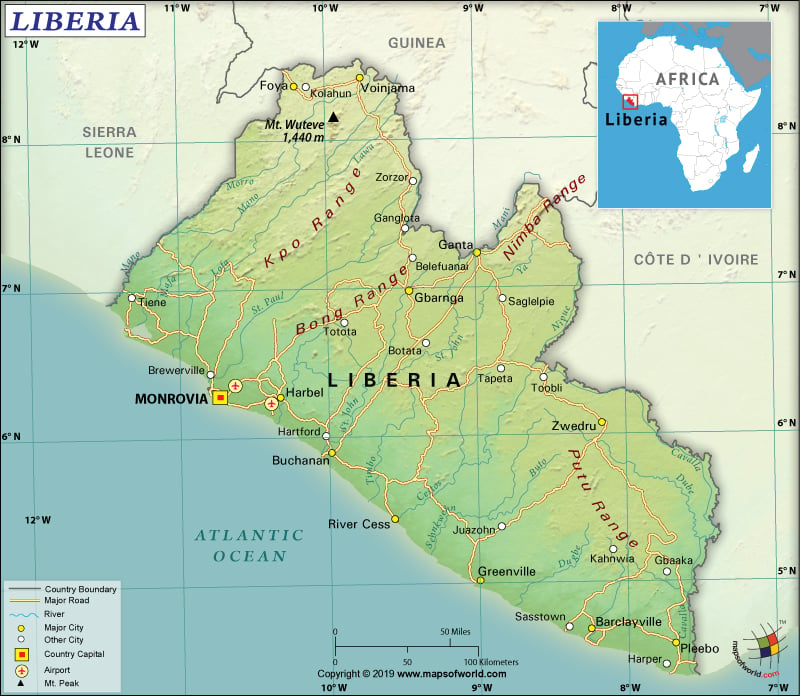
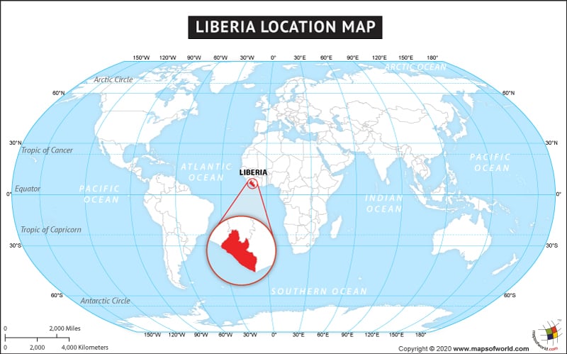
Liberia is a sub-Saharan country located in West Africa. It shares borders with three African countries including Cote d’Ivoire (778 km or 483 mi) to the east, Guinea (590 km or 367 mi) to the northeast, and Sierra Leone (299 km or 186 mi) to the northwest. To the southwest of Liberia, the North Atlantic Ocean is located.
What is the Geography of Liberia?
Liberia is spread across a total area of 111,369 sq. km (430,000 sq. mi), out of which 96,320 sq. km (37,189 sq. mi) is land area and 15,049 sq. km (5,810 sq. mi) is water area. While the total land boundary is 1,667 km (1,036 mi), the coastline is 579 km (360 mi).
Moreover, the landscape of Liberia mostly consists of flat-to-rolling coastal plains, containing swamps and mangroves. As one moves to the northeastern parts of the country, the coastal plains start rising to a rolling plateau as well as low mountains. While the hills are covered by the tropical forests, the northern sections mainly have semi-deciduous forests. Mano River traverses the main northwestern boundary of Liberia. The Cavalla River bounds the southeast limits of the country. St. Paul, Cavalla, Cestos River, and St. John are the main rivers of Liberia.
The mean elevation of the country is 243 m (797 mi). While the highest elevation is Mount Wuteve (Lofa) at 1,447 m (4,747 ft), the lowest elevation point is the sea level at the Atlantic Ocean. West Hill is the other major mountain.
Nearer south, Liberia has an equatorial climate and that’s why it remains hot around the year. From May-to-October, heavy rainfall takes place in this region. During mid-July-to-August, a short interlude of rainfall takes place. The inland areas get dry and dust-laden Harmattan winds blow during the winter season (November-to-March).
Generally, most precipitation in Liberia takes place in Cape Mount, located near the border with Sierra Leone. The coastal areas get more than 3,000 mm (118 in) of rainfall. Rainfall in the interior regions generally doesn’t exceed 2,000 mm (79 in) per year. During the day, the average temperature revolves around 30-32°C (86-90°F) in the coastal areas as well as forest areas in the interior. The nights are a bit colder. The humidity also remains high.
On the contrary, December-to-February is the short dry season of the country. Temperature slightly increases in March-April and the rainfall becomes more frequent. Temperature can exceed 40 °C (104 °F) during these months.
What is the Economy of Liberia?
Liberia is a low-income economy, whose nominal GDP was US$3.249 billion and the annual GDP growth rate slipped to 1.2% in 2018 (World Bank). The economy relies heavily on foreign aid, as well as remittances sent by the diaspora.
To begin with, the country is endowed with a climatic condition that is favorable to agriculture, forests, lots of water bodies, and mineral resources. Liberia’s main export items include gold, diamonds, rubber, and iron ore. Two new items are also emerging as export commodities, and they are cocoa and palm oil. The Liberian government is encouraging the exploration of oil, on the one hand, and trying to revive extraction of raw timber, on the other.
However, the Ebola crisis adversely affected the economy. Flight of capital took place when many foreign-owned businesses left the country in the wake of the epidemic. In fact, the funds available for public investment were also diverted to combat the Ebola crisis. Yet, higher donor support helped Liberia to sail through the crisis.
Additionally, the Liberian economy got a shot in the arm in 2017 when the growth was propelled by gold production and export. At Mount Gangra, Arcelor Mittal conglomerate opened their new mines, which also increased the exports of iron ore. The unemployment rate declined to 2.03% in 2018. Henceforth, the economic revitalization will depend heavily on adequate diversification, higher global prices of commodities, infrastructural & institutional development, maintenance of political stability, corruption control, and sustained foreign aid & remittances.
What is the Transportation System of Liberia?
Liberia has 70 airports and Roberts International Airport is the main airport of the country. There are 10,600 km (6,586 mi) of roadways present in the country. Most of the 9,943 km (6,178 mi) of roads are unpaved. Though 657 km (408 mi) roads are paved, they are deteriorating fast because of lack of maintenance as well as heavy rainfall. The major roadway of Liberia is Trans-West African Coastal Highway. No railway connection with neighboring countries is present. The country has some important ports and harbors such as Buchanan, Monrovia, Harper, and Greenville. 1,513 merchant marine ships are there in Liberia, as needed for heavy volume of exports.
What International Organizations is Liberia part of?
ACP, AfDB, UN, AU, IMF, ECOWAS, WHO, FAO, ILO, G-77, WIPO, IAEA, IBRD, IFRCS, UPU, ICAO, ICCt, NAM, ICRM, IDA, UNWTO, IFAD, Interpol, IFC, UNESCO, IMO, IMSO, UNCTAD, IOC, IOM, ITU, MIGA, UNIDO, MINUSMA, OPCW, WCO, WMO, ICC (NGOs), ITUC (NGOs), WFTU (NGOs), EITI (compliant country), ISO (correspondent), WTO (observer)


