What are the Key Facts of Kansas?

|
State |
Kansas |
|
State Capital |
Topeka |
|
Largest City |
Wichita |
|
Coordinates |
38.5°N 98°W |
|
Nickname(s) |
“The Sunflower State” (official), “The Wheat State”, “The Jayhawker State”, “The Free State” |
|
Postal Abbreviation |
KS |
|
Area |
82,278 sq. mi (213,100 sq. km), |
|
Highest Point |
Mount Sunflower, 4,041 ft (1,232 m) |
|
Number of Counties |
105 |
|
Neighboring States |
Nebraska, Missouri, Oklahoma, Colorado |
|
Population |
2,911,505 (2018) |
|
Date of Entering the Union |
January 29, 1861 |
|
State Anthem |
Home on the Range |
|
Governor |
Laura Kelly (Democratic Party) |
|
Lieutenant Governor |
Lynn Rogers (Democratic Party) |
|
U.S. Senators |
Pat Roberts (Republican), Jerry Moran (Republican) |
|
U.S. House Delegation |
Roger Marshall (Republican), Steve Watkins (Republican), Sharice Davids (Democratic Party), Ron Estes (Republican), Pat Roberts (Republican), Jerry Moran (Republican) |
|
GDP (Millions of Dollars) |
168318 |
|
Demonym |
Kansan, Jayhawker (Colloquial) |
|
Time Zones |
Majority of state UTC-06:00 (Central), Summer (DST) UTC-05:00 (CDT); Greeley, Hamilton, Sherman, and Wallace counties UTC-07:00 (Mountain), Summer (DST) UTC-06:00 (MDT) |
Where is Kansas?
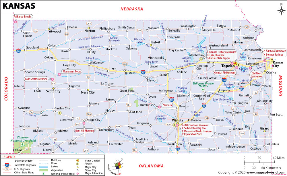
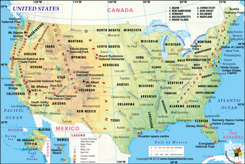
Kansas (the 34th state to be admitted to the union on January 21, 1861) is located in the Midwestern USA. This landlocked state is bordered to the west by Colorado, to the south by Oklahoma, to the east by Missouri, and the north by Nebraska.
What is the Geography of Kansas?
Kansas is spread across a total area of 82,278 sq. mi (213,100 sq. km), out of which 81,759 sq. mi (211,754 sq. km) is land area and 520 sq. mi (1,346 sq. km) is the water area. Water bodies occupy just 0.6% of the total area. This state is around 400 mi (644 km) long and 210 mi (338 km) wide. In terms of the total area, Kansas is the 15th largest state.
The mean elevation of this state is 2,000 ft (610 m) above sea level. While Mount Sunflower at 4,039 ft (1,231 m) above sea level is the highest elevation point in the state, the Verdigris River at 679 ft (207 m) above sea level is the lowest elevation point.
Some of the major mountains in this state are Mount Sunflower, Rock Hill, Horsethief Draw, Salt Grass Canyon, Clough Valley, Pasture Number Eighteen, Stateline Pasture, Unit One Pasture, Meyers Draw, Pasture Number Fortyseven, etc. The major rivers in the state are Missouri River, Arkansas River, Cimarron River, Smoky Hill River, Neosho River, Republican River, Saline River, Kansas River, Big Blue River, Verdigris River, South Fork Solomon River, etc.
Kansas is named after the Kansas River, which in turn got its name from the Kansa Native Americans that lived along its banks.
The principal lakes of the state are Milford Lake, Waconda Lake, Tuttle Creek Lake, Perry Lake, Cheney Reservoir, John Redmond Reservoir, Wilson Lake, El Dorado Lake, Clinton Lake, Malvern Lake, etc.
Some rolling plains rising in elevation from east to west is the major terrain in Kansas. There are three major geographic regions in the state, and they are the Dissected Till Plains, the Southeastern Plains, and the Great Plains.
The Dissected Till Plains are situated in the northern parts of the state and is characterized by a rich and fertile soil that was left behind by the glaciers thousands of years back. This plain roughly occupies the northern parts of the Kansas River as well as the east of the Big Blue River. High bluffs have been created as the rivers and streams dissect the landscape.
The Southeastern Plains are located to the south of the Dissected Till Plains. This plain stretches in the south from Kansas to the Oklahoma border and then extends towards central Kansas to the west. A few hills interrupt the gently rolling landscape. This plain can be divided into two sections.
While one is the Osage Plains, the other is the Flint Hills. While the erosion of limestone and shale had led to the formation of the Osage Plains in the east, the Flint Hills were formed by limestone and flint ridges that were erosion resistant. The Flint Hills are located to the west of the Osage Plains.
The Great Plains covers the western half of the state. As you move from the east towards the west along the Colorado border, the land slopes up from 1,500 ft (457 m) to around 4,000 ft (1,219 m) above sea level. The High Plains have a gently rolling landscape. It is located in the western part. The highest elevation point in Kansas is located in the Great Plains geographical area.
What is the Climate of Kansas?
A temperate but continental climate is found in Kansas. It is characterized by extreme hot and extreme cold weather during summer and winter respectively, but neither extremely hot nor severe cold weather prevails for an extended period.
The average annual temperature revolves around 55 °F (13 °C). The monthly average high temperature revolves within a high of 92.9 °F (33.8 °C) to a low of 15.7 °F (-9 °C). The average annual rainfall level hovers around 25 inches (635 mm). While the western part gets less than 20 inches (500 mm) of rainfall, the southeastern part gets over 40 inches (1,000 mm) of rain.
The frost-free season (also called growing season because it is best for growing indigenous vegetation and cultivating crops) starts in mid-April and continues till mid-September.
What is the Economy of Kansas?
The total Gross Domestic Product (GDP) for Kansas increased significantly in the last decade, from US$127,682.4 million in 2008 to US$168,318 million in 2018. The Real Median Household Income in the state first declined from US$55,975 in 2008 to US$51,632 in 2013. However, it later increased significantly to US$63,938 in 2018. The Per Capita Personal Income also improved handsomely from US$40,791 to US$51,471 during 2008-2018.
In 2018, the value of total exports and imports were US$11,586,747,077 and US$12,305,459,784 respectively, resulting in a trade balance of -$718,712,707. The major exports of this state are Aircraft, Meat, Industrial Machinery, Cereals, Electrical Machinery, Oil Seeds, Motor Vehicles and Parts, Animal Feeds, Precision Instruments, etc. The major imports were Industrial Machinery, Electrical Machinery, Footwear, Aircraft, Precision Instruments, Motor Vehicles and Parts, Base Metal Articles, Plastics, Knit Apparel, etc.
Historically, Kansas is an agricultural state. It is the leading wheat-producing state in the country. In terms of the production of sorghum and corn, it is again a leading state. Though in terms of income generation, the manufacturing and service sector has surpassed agriculture, farming is still a significant aspect of the state economy.
In terms of agricultural acreage, it is among the top five states. Some of the other main crops produced by the state are sunflowers, soybeans, and hay. In terms of overall agricultural production, Kansas is among the top-10 largest states.
The rate of unemployment increased rapidly from 4.6% in January 2008 to a peak of 7.9% in July 2009. However, it has now come down to 2.8% in November 2019. Kansas had an 11.9% rate of poverty in 2018. Out of a total population of 2,827,376, the number of persons in poverty is 336,487.
What is the Transportation System of Kansas?
The Interstate Highways in Kansas are part of the Dwight D. Eisenhower National System of Interstate and Defense Highways. The major interstate highways are I-35, I-35W, I-70, I-135, I-235, I-335, I-435, I-470, I-635, and I-670.
This state has an intricate network of state highways that are owned and maintained by the Kansas Department of Transportation (KDOT). The state highways include K-1 to K-296, K-334, K-360, K-368, and K-383.
The major airports in Kansas are Wichita Dwight D. Eisenhower National Airport (in Wichita), Manhattan Regional Airport (in Manhattan), Garden City Regional Airport (in Garden City), Topeka Regional Airport (in Topeka), Hays Regional Airport (in Hays), Salina Municipal Airport (in Salina), Liberal Mid-America Regional Airport (in Liberal) and Dodge City Regional Airport (in Dodge City).
Why is Kansas called the “The Sunflower State”?
The official nickname of Kansas is “The Sunflower State” because wild sunflowers grow across the state. Sunflower is also the official flower of Kansas, which first became official in 1903.
The other nicknames of the state are “The Wheat State”, “Midway, USA”, “The Central State”, “The Jayhawk State”, “The Cyclone State”, “The Grasshopper State”, “The Battleground of Freedom”, “Bleeding Kansas”, “Garden of the West”, etc.
What are the Popular Tourist Attractions in Kansas?
Botanica: Wichita Gardens, Kansas State Capitol, Eisenhower Presidential Library, Museum, and Boyhood Home, Tallgrass Prairie National Preserve, Boot Hill, Evel Knievel Museum, Spencer Museum of Art, Flint Hills Discovery Center, Monument Rocks, Fort Larned National Historic Site, The Keeper of the Plains, Kansas Speedway
Facts About Kansas
1) Kansas is nicknamed “The Sunflower State”.
2) The capital of Kansas is Topeka and the largest city is Wichita.
3) The official bug of the state is the Honeybee.
4) Abilene is the hometown of Dwight D. Eisenhower, the 34th U.S. President. It also houses the famous Eisenhower Museum.
5) Kansas was admitted to the Union on January 29, 1861 and became the 34th state.
6) The state shares its borders with Missouri, Nebraska, Colorado, and Oklahoma.
7) The official flower of the state is the Sunflower.
8) The University of Kansas is famous for the invention of Helium gas.
9) The famous natives of Kansas include Walter P. Chrysler, Buster Keaton, and Dwight D. Eisenhower.
10) Major natural resources of the state include oil, granite, and natural gas.
11) The official bird is the Western Meadowlark.
12) The official reptile of the state is the Ornate Box Turtle.
13) The official motto is “To the Stars through Difficulties”.
14) People of Kansas are called as Kansans.
15) Kansas Day is observed on January 29 every year.
16) Wichita is dubbed as “The Air Capital of the World”.
17) The official anthem is “Home on the Range”.
18) Sumner County of this state is nicknamed the Wheat Capital of the World.
19) The yearly average temperature of the state is 56 degree F and the yearly average precipitation is 27 inches.
20) The official animal is American Bison.
Related Links:


