What are the Key Facts of Indonesia?
|
Official Name |
Republic of Indonesia |
|
Continent |
Asia |
|
Capital |
Jakarta |
|
Largest City |
Jakarta |
|
Coordinates |
-5.000000, 120.000000 |
|
Area |
735,358 sq. mi ( 1,904,569 sq. km) |
|
Land Boundaries |
1,838 mi ( 2,958 km) |
|
Coastline |
33,999 mi ( 54,716 km) |
|
Currency |
Indonesian rupiah (Rp) (IDR) |
|
Neighboring Countries |
Malaysia, Papua New Guinea, Timor-Leste Maritime neighbors: India, Singapore, Vietnam, the Philippines, Palau, and Australia. |
|
Population |
261,115,456 (2016 est.) |
|
Official Languages |
Indonesian |
|
Major Religion |
Islam |
|
National Day |
17 August (Independence Day) |
|
National Anthem |
“Indonesia Raya” |
|
Form of Government |
Unitary presidential constitutional republic |
|
President |
Joko Widodo |
|
Vice President |
Ma’ruf Amin |
|
GDP per capita (PPP) |
$ 13,056.6 (World Bank, 2018) |
|
GDP per capita (nominal) |
$ 3,893.6 (World Bank, 2018) |
|
HDI |
0.694 (2017), Rank: 116 |
|
Literacy Rate (%) |
95.38 (UNESCO, 2016) |
|
Space Agency |
NA |
|
Military Expenditure Ranking |
26 (SIPRI, 2017) |
|
No. of Olympic Medals |
32 (as of 2018) |
|
Driving Side |
left |
|
Calling Code |
+62 |
|
Time Zone |
UTC+7 to +9 |
|
Internet TLD |
.id |
Where is Indonesia?
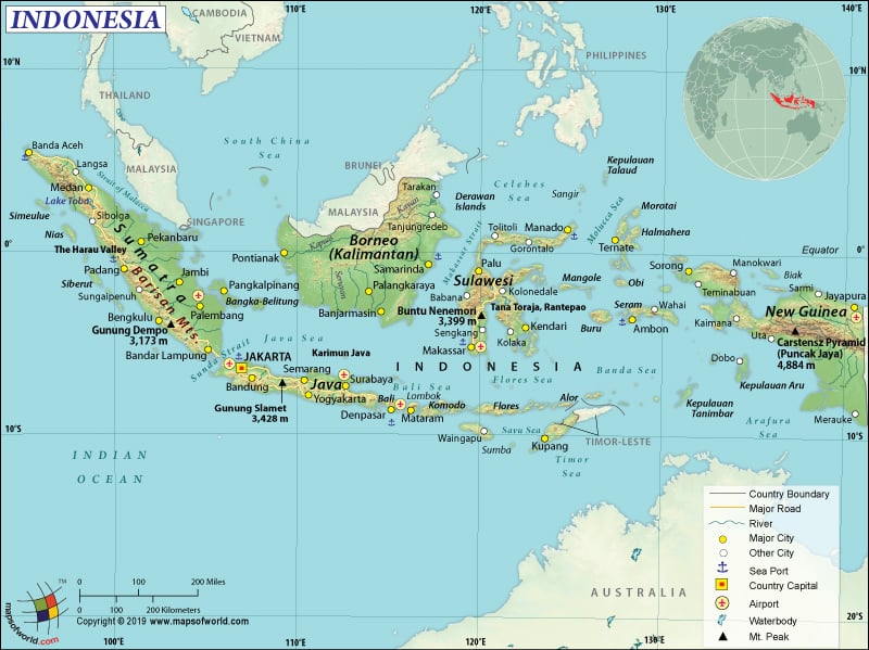
Indonesia is a beautiful archipelago nestled in the Asian peninsula along the South East Asia and Australia. The country is made up of over 17,500 islands, of which 6,000 are inhabited and nearly 1,000 are permanently settled. Indonesia outstretches on both sides of the Equator, while lying in the middle of the Indian and Pacific Oceans. The country is bordered by Malaysia along the island of Borneo, Papua New Guinea along the province of New Guinea and East Timor along the island of Timor.
The five major islands of the region are Java, Sumatra, Kalimantan (the Indonesian part of Borneo), Irian Jaya, and Sulawesi. The two other archipelago of the region are Nusa Tenggara and the Maluku Islands. The archipelago can be separated into several divisions, namely The Greater Sunda islands, The Smaller Sunda islands, and East Indonesia.
The islands of Sumatra, Java (which was known as Madura), Kalimantan (formerly named as Borneo), and Sulawesi (called as Celebes previously) fall within the sector of Greater Sunda Islands.
The Sulawesi seems to be a part of the Sunda Shelf that has extended from the Malay Peninsular region to the Southeast Asian region. Irian Jaya, which was previously called as Irian Barat or West New Guinea falls under the Sahul Shelf sector, is a part of the New Guinea Island. The Smaller Sunda Islands is comprised of Bali, Lombok, Sumbawa, Flores, Komodo, etc., which are even referred as Nusa Tenggara.
What is the Geography of Indonesia?
Indonesia is spread over 1,904,569 sq. km (735,358 sq. mi), of which 1,811,569 sq. km (699,451 sq. mi) is land area and 93,000 sq. km (35,908 sq. mi) is water area. It is the world’s largest archipelagic state. The total land boundary of Indonesia is only 2,958 km (1142 mi), while the coastline is 54,716 km (21,126 mi). The border countries of Indonesia are Malaysia (1,881 km or 726 mi)), Papua New Guinea (824 km or 318 mi), and Timor-Leste (253 km or 98 mi).
The mean elevation of Indonesia is 367 m (1,204 ft). While the lowest elevation point is sea level at Indian Ocean, the highest elevation point is Puncak Jaya at 4,884 m (16,024 ft). Other mountains with high elevation are Pancak Trikora at 4,750 m (15,584 ft), Mount Yamin at 4,087 m (13,409 ft), Sumatri at 4,870 m (15,978 ft).
Besides, 51.7% of the land in Indonesia is covered by forests. The land use for agricultural purposes is 31.2%, of which arable land is 13%, permanent crops is 12.1% and permanent pasture is 6.1%. The total irrigated land is at 67,220 sq. km (25,954 sq. mi). Only 17.1% of land in the country is used for other purposes.
Further, the major concentration of Indonesia’s population is on the island of Java, which is also considered one of the most densely populated places on earth. The outer island which is surrounded by Java and Bali, i.e. Sumatra, carries some of the most significant clusters, specifically in the south near Selat Sunda and also north eastern coast near Medan.
Apart from these, Banjarmasin (Kalimantan), and Makasar (Sulawesi) are also highly populated.
Indonesia is quite prone to natural disasters. The region is located on the periphery of the three tectonic plates, which include the Pacific, Eurasian, and Australian plates. This makes the area vulnerable and prone to earthquakes followed by tsunamis. Indonesia is hit with about 66 volcanoes, whereas the Krakatoa area nestled near Sumatra and Java is prone to acute eruption. Some of the frequent natural disasters observed here are floods, severe droughts, forest fires, earthquakes, and tsunamis, to name a few.
In terms of climate, Indonesia can be divided into two seasons:
· The dry season, that extends from the month of June to October, and
· The rainy season, which runs from November to March
The climatic condition of Indonesia is affected by the structure of the island that is placed across the Equator, lying in the midst of Asia and Australia. It is manifested in even and high temperatures within the area along with slight monsoon based downpour.
Temperatures are uniformly high near the coastal region, with an annual rise in temperature to about 23 to 31 °C (73 to 88 °F) that becomes moderate when it reaches approximately above 610 m (2,000 feet) height. Maoke Mountains of Papua receive sufficient snowfall while the region of Sumatra, Kalimantan, Celebes, and Papua mountain ranges get the highest amount of precipitation.
There is a change in the seasonal pattern, which is based on the air that drifts from the monsoon pattern and meets the tropical air blowing from the north and south of the Equator, which creates a low pressure within the area. It is during the month of December, January, and February that the west monsoon brings along heavy precipitation to the regions of southern Sumatra, Java, and the Lesser Sunda Islands. Usually in the months of June, July, and August, the east monsoon, carries dry air from Australia affecting the regions of Lesser Sunda Islands and eastern Java. When the east monsoon passes through the Equator – that changes into the southwest monsoon belonging to the Northern Hemisphere- the winds bring along humidity followed with rain.
What is the Economy of Indonesia?
Indonesia has the largest economy in South East Asia, with well-defined contribution from the private sector as well as the government. Its nominal Gross Domestic Product was estimated at $1.042 trillion in 2018. Moreover, the country’s GDP per capita rose steadily from $807 in the year 2000 to $3,877 in 2018, overcoming challenges of the Asian financial crisis in the 1990s and the global crisis in 2008 (World Bank).
Since it is the fourth most populous nation in the world, domestic demand is considered to be the main driver of economic growth in Indonesia. For 2019, the growth rate is forecast to reach 5.2%. Agriculture remains a major occupation in Indonesia, providing employment to 31% of the population. Some of the agricultural products are spices, fish, essential oils, rubber, palm oil, poultry, beef, forest products, shrimp, cocoa, coffee, medicinal herbs to name a few. Yet, in terms of contribution, the service sector contributes 43.6%, industry 39.3% and agriculture only 13.1% to the GDP. Some of the popular industries are handicrafts, chemical fertilizers, plywood, rubber, processed food, jewelry, tourism, cement, mining, footwear, automotive, textiles, natural gas, and medical instruments.
However, around 9.8% of the population of Indonesia was still living below the poverty line in 2018. Unequal distribution of resources, corruption, inadequate infrastructure, poverty, and poor quality of healthcare and education hamper achievement of higher living standards.
The country witnessed a high growth rate in the 1980s and 1990s on the back of increasing exports of manufactured products. Nevertheless, the pace has slackened after the 1997 Asian financial crisis. China, the United States, Japan, Singapore, India, Malaysia, South Korea and Thailand are Indonesia’s strategic export and import partners.
What is the Transportation System of Indonesia?
Indonesia has an advanced transportation system which includes roadways of 496,607 km (308,577 mi). Of these, more than 50%, i.e. 283,102 km (175,911 mi) length is paved while 213,505 km (132,666 mi) is unpaved. The waterways of the country are 21,579 km (13,409 mi) long. It also has a railway network of 8,159 km (5070 mi) as per 2014.
Indonesia is also home to both paved (186) and unpaved (487) airports. Heliports are a total of 76 as per 2013. The number of registered air carriers was 29 in 2015. The major seaports are Tanjung Priok, Tanjung Perak, Sungai Pakning, Panjang, Palembang, Krueng Geukueh, Kotabaru, Belawan, and Banjarmasin. The country possesses around 9,053 merchant marines, including oil tankers, bulk carriers, container ships and general cargo.
What International Organizations is Indonesia part of?
ADB, APEC, ARF, ASEAN, BIS, CD, CICA, (observer), CP, D-8, EAS, EITI (compliant country), FAO, G-11, G-15, G-20, G-77, IAEA, IBRD, ICAO, ICC (national committees), ICRM, IDA, IDB, IFAD, IFC, IFRCS, IHO, ILO, IMF, IMO, IMSO, Interpol, IOC, IOM (observer), IORA, IPU, ISO, ITSO, ITU, ITUC (NGOs), MIGA, MINURSO, MINUSTAH, MONUSCO, MSG (associate member), NAM, OECD (enhanced engagement), OIC, OPCW, PIF (partner), UN, UNAMID, UNCTAD, UNESCO, UNIDO, UNIFIL, UNISFA, UNMIL, UNWTO, UPU, WCO, WFTU (NGOs), WHO, WIPO, WMO, WTO.
Related Links:

