What are the Key Facts of Cabo Verde?
|
Official Name |
Republic of Cabo Verde |
|
Continent |
Africa |
|
Capital |
Praia |
|
Largest City |
Praia |
|
Coordinates |
16.000000, -24.000000 |
|
Area |
1,557 sq. mi ( 4,033 sq. km) |
|
Land Boundaries |
0 mi ( 0 km) |
|
Coastline |
600 mi ( 965 km) |
|
Currency |
Cape Verdean escudo (CVE) |
|
Neighboring Countries |
Maritime neighbors: The Gambia, Guinea-Bissau, Mauritania, and Senegal |
|
Population |
539,560 (2016 est.) |
|
Official Languages |
Portuguese |
|
Major Religion |
Christianity |
|
National Day |
5 July (Independence Day) |
|
National Anthem |
“Cantico da Liberdade” |
|
Form of Government |
Unitary semi-presidential republic |
|
President |
Jorge Carlos Fonseca |
|
Prime Minister |
Ulisses Correia e Silva |
|
GDP per capita (PPP) |
$ 7,494.7 (World Bank, 2018) |
|
GDP per capita (nominal) |
$ 3,654.0 (World Bank, 2018) |
|
HDI |
0.654 (2017), Rank: 125 |
|
Literacy Rate |
86.79 (UNESCO, 2015) |
|
Space Agency |
NA |
|
Military Expenditure Ranking |
147 (SIPRI, 2017) |
|
No. of Olympic Medals |
0 (as of 2018) |
|
Driving Side |
right |
|
Calling Code |
+238 |
|
Time Zone |
UTC-1 (CVT) |
|
Internet TLD |
.cv |
Where is Cabo Verde?
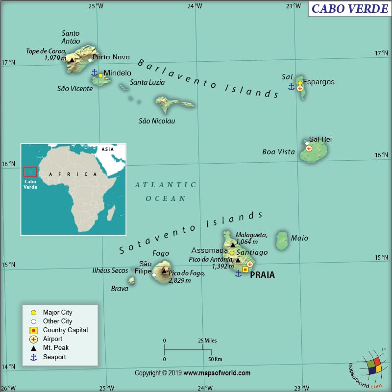
Cabo Verde or Cape Verde is an island nation, located in the westernmost Cape of Africa. This archipelago (consisting of ten islands and eight islets) is situated to the west of Senegal in the Atlantic Ocean.
What is the Geography of Cabo Verde?
Cabo Verde is spread across a total area of 4,033 sq. km (1,557 sq. mi), out of which the 4,033 sq. km (1,557 sq. mi) is land area and 0 sq. km (0 sq. mi) is water area. It doesn’t share its land boundaries with any other country. This group of islands has a 965 km (600 mi) long coastline. While Mt. Fogo at 2,829 m (9,281 ft) on the Fogo Island is the highest elevation point of the country, the Atlantic Ocean at 0 m (0 ft) is the lowest elevation point.
The Cabo Verde archipelago islands can be divided into two parts. While one is the Windward Islands, the other is the Leeward Islands. Santa Luzia, Sao Nicolau, Santo Antao, Sao Vicente, Sal, and Boa Vista are categorized as the Windward Islands. Santiago, Brava, Fogo, and Maio are categorized as the Leeward Islands.
The largest island is known as Santiago. The landforms of Cabo Verde are characterized by steep, rocky, volcanic, and rugged hills/mountains. On the Sal and Maio islands, extensive salt flats can be found. On the islands of Santiago, Sao Nicolau, and Santo Antao, arid slopes transition into sugarcane fields.
The major mountains of Cabo Verde are Pico Do Fogo, Monte Verde, Serra da Malagueta, and Topo da Coroa. There are no major rivers in the country. However, some of the streams present in the country are Ribeira Grande de Santiago, Ribeira da Trindade, Ribeira de Alto Mira, Ribeira Grande, Ribeira da Torre, Ribeira do Calhau, etc.
Cabo Verde has a subtropical climate, which remains pleasant throughout the year. A windy season known as Tempo de Brisas prevails from October to mid-July. The rainy season generally starts from August and continues till September. The country gets lots of sunshine throughout the year. During March to May, Cape Verde gets the longest days of the year.
The average temperature during the Windy Season varies from 25 ˚C to 29 ˚C (77 ˚F to 84 ˚F). The sea temperature usually remains 23 ˚C (73 ˚F) or above from October to mid-July. High temperature can remain above 30 ˚C (86 ˚F) during the rainy season and therefore rain can bring relief to the hot and perspiring condition. During August and September, the sea temperature remains around 27 ˚C (91 ˚F).
February-to-June is the most pleasant time to visit Cabo Verde as the average temperature revolves around 23 ˚C (73 ˚F). The Winward islands remain cooler than the Leeward Islands.
What is the Economy of Cabo Verde?
The nominal GDP of Cabo Verde in 2018 was US$1.987 billion and it grew at 5.5% (higher the 4% growth rate in 2017). This middle-income economy is mainly dependent upon tourism, remittances, foreign investment, and developmental aid. 3/4th of the GDP contribution comes from the service-oriented economy, which is mainly dependent upon tourism, commerce, public services, and transport. As the country has a large pool of emigrants, it has the highest remittance-GDP ratio in entire sub-Saharan Africa. The World Bank’s report shows that Cabo Verde has a negative trade balance, which was -18.87% of the GDP in 2018.
The country has to import a significant amount of its food items because of the low food production level, which is mainly because of the poor quality of soil, serious water shortage, and poor natural resource base. Though the archipelago has immense potential for fishing (mainly tuna and lobster), the optimum level is not yet reached.
Around 40% of Cape Verde’s population still lives in rural areas. Most of its labor force is involved in fish processing, foods, beverages, salt mining, garments, shoes, and ship repair. The unemployment rate in Cabo Verde was 12.28% in 2018. Around 30% of the population is reeling under poverty. World Bank’s report says that 14% of the total population is still suffering from extreme poverty.
What is the Transportation System of Cabo Verde?
Airways are the most important transportation system of Cape Verde. Santiago, São Vicente, and Sal islands get regular flights. Flights are available from other islands of the archipelago country, but they are less frequent. There are 9 airports in the country and all of them have paved runways. TACV Cabo Verde Airlines is the national airliner of the country.
Roadways are the major transport system on each island. There is around 1,350 km (839 mi) of roadways available in the country, out of which 932 km (579 mi) are paved and 418 km (260 mi) are unpaved. 12-to-14 passenger shared minibuses (also known as “yasi” because most of these minibuses are Toyota HiAce) are the main transport system within the islands. Toyota Hilux is used as modified pickup trucks.
Inter-Island ferries are also available in Cape Verde and these are the preferred mode of transport for the locals because of their lower fares. The country also has 43 merchant marine ships. The main seaport of Cabo Verde is Porto Grande.
What International Organizations is Cabo Verde part of?
WTO, AFD, European Union, AECID, UN, AFDB, WTO, INTERPOL, UNWTO

