What are the Key Facts of Belize?
|
Official Name |
Belize |
|
Continent |
North America |
|
Capital |
Belmopan |
|
Largest City |
Belize City |
|
Coordinates |
17.250000, -88.750000 |
|
Area |
8,867 sq. mi (22,966 sq. km) |
|
Land Boundaries |
337 mi ( 542 km) |
|
Coastline |
240 mi ( 386 km) |
|
Currency |
Belize dollar (BZD) |
|
Neighboring Countries |
Mexico, Guatemala |
|
Population |
408,487 (2019 est.) |
|
Official Languages |
English |
|
Major Religion |
Christianity |
|
National Day |
21 September (Independence Day) |
|
National Anthem |
“Land of the Free” |
|
Form of Government |
Unitary parliamentary constitutional monarchy |
|
Monarch |
Elizabeth II |
|
Prime Minister |
Dean Barrow |
|
GDP per capita (PPP) |
$ 8,786.5 (World Bank, 2018) |
|
GDP per capita (nominal) |
$ 5,025.2 (World Bank, 2018) |
|
HDI |
0.708 (2017), Rank: 106 |
|
Literacy Rate (%) |
NA |
|
Space Agency |
NA |
|
Military Expenditure Ranking |
141 (SIPRI, 2017) |
|
No. of Olympic Medals |
0 (as of 2018) |
|
Driving Side |
right |
|
Calling Code |
501 |
|
Time Zone |
UTC−6 (CST) |
|
Internet TLD |
.bz |
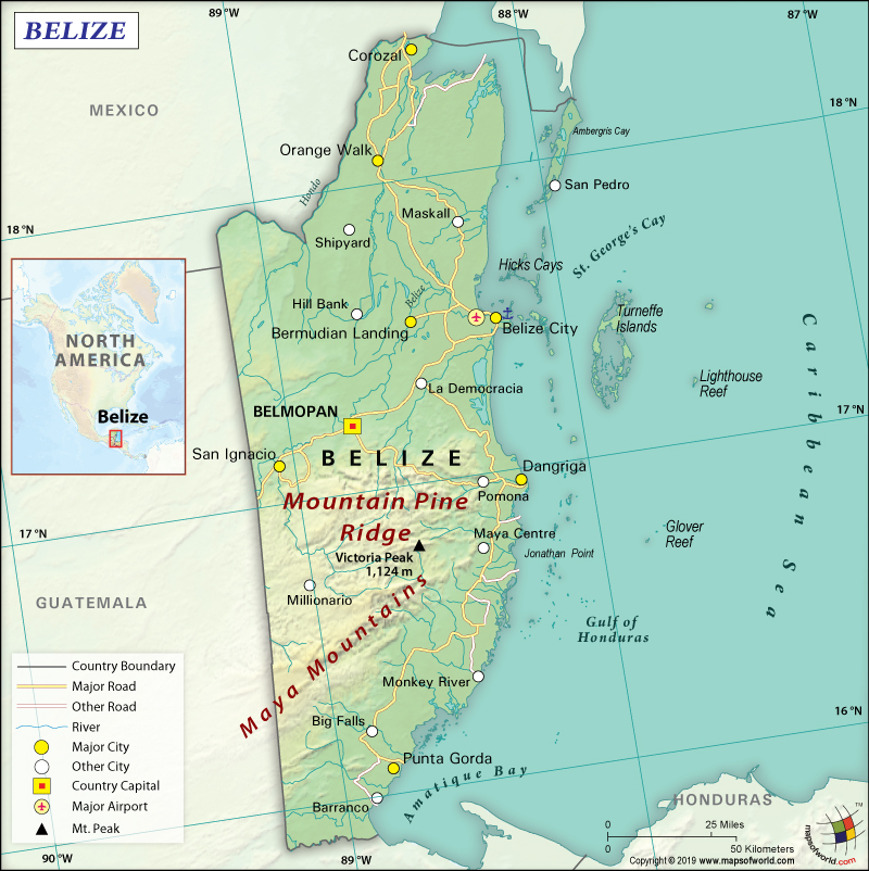
Belize on World Map
Belize is a Central American country that is located between Guatemala and Mexico bordering the Caribbean Sea. Formerly known as British Honduras, this small country is situated in the Yucatan Peninsula’s southeast part.
What is the Geography of Belize?
Belize has a total area of 22,966 sq. km (8,867 sq. mi), out of which the majority 22,806 sq. km (8,805 sq. mi) island area and 160 sq. km (62 sq. mi) is water area. It has a 542 km (337 mi) long land boundary, which is shared with Mexico (276 km or 171 mi) and Guatemala (266 km or 165 mi). Belize has a 386 km (240 mi) long coastline.
Generally speaking, the mean elevation of the country is 173 m (568 ft). While Doyle’s Delight at 1,124 m (3,688 ft) is the highest point of Belize, the lowest elevation point is sea level at the Caribbean Sea. There are three major mountains and they are Doyle’s Delight, Victoria Peak, and the Maya Mountains. The major rivers in this Central American country are Belize River, Macal River, Mopan River, New River, Northern River, Rio Hondo, Sibun River, and many more.
Additionally, the landforms of Belize can be categorized into 4 regions: Maya Mountains (relatively low at height) in the southern parts of the country except the narrow coastal plains, the lowlands along with multiple rivers and streams in the northern parts of the country, narrow coastal plain in the south (usually flat and swampy), and numerous cays/islands/lagoons along the fringe Caribbean coastline.
Moreover, more than half of the landform in Belize is covered by the tropical rainforest along with numerous river networks running through them. Belize River is the most important navigable river in the country that stretches from the Guatemalan border to the Caribbean Sea.
In front of the coastline of Belize, there is a 282 km (175 mi) long barrier reef, which is the world’s second-largest barrier reef (second only to Australia’s Great Barrier Reef). This barrier reef is intermixed with hundreds of islands and cays. One of the most popular diving sites of the world, the Blue Hole (over 1,000 ft across and around 400 ft deep), is located around 93 km (58 mi) east of Belize City.
In addition, the climate of Belize is tropical. While the weather remains cooler during November-to-February, it remains hot and rainy during June-to-October. The northeast trade winds prevail during the latter period of the rainy season, causing some rainfall. However, the precipitation level decreases afterward, thereby leading to an absolute dry period from February-to-April.
In fact, the heat starts increasing from March-to-May. The hottest months of the year are April and May. In inland areas, the days remain scorching. Especially in the southern parts of the country, thunderstorms become frequent in the month of May. In this part, the rainy season actually starts in May. Belize’s landscape is covered by a tropical forest, thanks to the high rainfall and humidity.
The northern and southern parts of the country have an average temperature of 23 ˚C (73 °F) and 24 °C (75 °F) respectively. The island of Ambergris Caye gets an average temperature of 25 °C (77 °F) with highs of around 26-27 °C (79-81 °F).
During December-to-March, the Norte wind coming from the United States makes the weather a bit cooler and also brings rainfall with itself. The sky remains cloudy during this time. The nighttime temperature can drop to around 13-15 °C (55-59 °F). During June-to-October, the average temperature revolves around 27-28 °C (81-82 °F). The highest temperature reached during this season is around 30-32 °C (86-90 °F).
The southern regions get more rain than the northern regions. The northern islands and cities get around 1,300-1,800 mm (51-70 in) of annual rainfall. The southern cities get 1,900-to-over-3,000 mm (75-to-over-118 in) rainfall per year.
What is the Economy of Belize?
As a matter of fact, Belize is an upper-middle-income economy that is heavily dependent upon private enterprises. Tourism is the main foreign exchange earner of the country. Other items exported by the company are crude oil, marine products, sugar, citrus, and bananas. In 2018, the Belize economy increased at a rate of 3.05%, taking the nominal GDP to US$1.925 billion.
In order to spur growth, the government in Belize adopted the policy of expansionary monetary and fiscal policies in 1998, which led to an average growth rate of around 4% during 1999-2007. During the period 2007-2016, the GDP increased at an average of 2.1%. It reached 2.5% in 2017, followed by 3.05% in 2018. As the economy is heavily dependent upon the import of energy, the economy remains volatile to sudden spurts in the price of energy.
Despite Belize having one of the highest per capita incomes among the Central American countries, there is huge income disparity among the population. The main challenges of the government remain the reduction of inequality and poverty, bring down the foreign debt burden, contain the expanding trade deficit, and lessen high unemployment. While 43% of the total population lives in poverty, 16% live in extreme poverty in Belize.
What is the Transportation System of Belize?
Belize has 3,281 km (2,039 mi) of roadways, out of which only 601 km (373 mi) is paved, and the rest 2,680 km (1,665 mi) is unpaved. 825 km (513 mi) of waterways are navigable, especially by small crafts. Belize City and Big Creek are the major seaports of Belize. There are 764 merchant marine ships available in the country. This Central American country has 47 airports, out of which 6 have paved runways and 41 have unpaved runways.
What International Organizations in Belize part of?
WTO, UN, IMF, Interpol, ILO, NAM, Petrocaribe, ACP, AOSIS, C, Caricom, CD, CDB, CELAC, FAO, G-77, IADB, IAEA, IBRD, ICAO, ICRM, IDA, IFAD, IFC, IFRCS, IMO, IOC, IOM, ITU, LAES, MIGA, OAS, OPANAL, OPCW, PCA, SICA, UNCTAD, UNESCO, UNIDO, UPU, WCO, WHO, WIPO, WMO, ICC (NGOs)
Related Link:


