What are the largest rivers by discharge?
The rivers bless us with various requisites essential for survival. Being one of the most significant sources of freshwater, all life-forms rely greatly on rivers for sustenance. Early civilizations reflect the relevance of rivers as an important determining factor for settlements. The proximity to a river or a waterbody was a major consideration for early settlers to initiate a livelihood. The availability of freshwater for consumption, fertile soil for cultivation and a support system for flora and fauna are few features that are offered by the rivers.
A river is a natural flowing course of water, towards another waterbody like an ocean, sea or a lake. In certain cases, rivers run underground eventually running dry without meeting another body of water. A river discharge, is defined as the total amount of water passing a measuring point in a river, at a given time. It is measured in cubic feet per second. This volumetric flow rate can also be considered as the mean velocity of the flow through a given cross-sectional area.
The river drainage system is dependent on numerous aspects. These are the rate of precipitation, the storage rate and the rate of evaporation or transpiration. It is the relationship between these three factors that defines the average drainage rate of a river. In addition to this, the velocity of a river is affected by the depth of the river, sharing a positive relationship. A river drainage basin is inclusive of various landforms, topography, rock and soil type and weather conditions, which collectively contribute to the volume of the river.
The permeable rocks and soils (sandy soils) are highly absorbent and have relatively lower surface run-off. Whereas impermeable rocks (clay soils) and soils are more closely packed, resulting in the lesser infiltration of rainwater, having larger run-off. Similarly, pervious rocks like limestone and porous rocks like chalk, allow water to pass through joints and spaces between the rock particles, resulting in lesser water reaching the rivers.
Rainfall patterns are another leading contributor to the volume of a river. The amount and type of rainfall affects a river’s discharge. A saturated ground due to antecedent rainfall, will result in larger surface run-off towards the river. A heavy rainfall and melting of mountain tops also add to the volume of the river. This is also complementary to the type of slope of a region, a steep slope will lead to lesser infiltration and higher surface-runoff, whereas a gentle slope will leave more scope for the rainwater to invade into the surface rocks and soils.
In urban areas, concrete roads and deforestation leads to a larger run-off of the rainwater into the drains and eventually spilling into the rivers. A cross-sectional ploughing in the rural areas and the hills refrains the water from running off into the rivers.
Lastly, the weather conditions of each region largely vary, this affects the evaporation rates and the types of soil available. Hot dry weathers and high temperature results into higher evaporation rates and higher transpiration reducing the discharge. A cold weather, freezes the ground water and the water cannot be soaked in, running straight into the rivers. Hence, the total amount of water transported downstream will be a combination of free water flow and the contribution from the sub-surface rocks and gravel that underlie the river and its floodplain.
The spread of human settlements and over-exploitation of the rivers has brought us in terms with water crisis and the need to conserve waters sources. The possibility of life on the planet cannot be independent of the presence of the rivers. They not only form a support system to the ecosystems but also are significant in carrying out various economic activities. Humans have been dependent on the rivers for broad range of reasons including navigation, transportation, food, water and other economic activities. Rivers are often worshipped in several countries due to their significant benefactions to the existence of civilizations over the years.
The top 3 largest rivers by volumetric flow are:
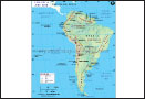
The Amazon River: The largest river by volume, the river Amazon, represents 20% of the global riverine discharge to the Atlantic Ocean. Also featuring the largest basin, it has a drainage area of 2,722,020 square miles. With an average discharge of 7,400,000 cubic feet per sec, the river is greater than the next seven largest independent rivers combined. It drains from West to East originating in Peru, across Brazil to the Atlantic.
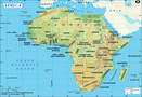
The Congo River: The second largest river by discharge and the deepest river of the world is also the second longest river in Africa after Nile. Having a drainage area of 1,550,007 square miles, it is the only river to cross the equator twice. It covers 13% of the entire African landmass and has a tremendous volumetric flow of 1,400,000 cubic feet per second. The river and its tributaries drain through the Congo Rainforest. The source of the river is in the highlands and mountains of the East African Rift as well as Lake Tanganyika and Lake Mweru.
The Orinoco River: Being one of the longest rivers of South America with a length of 1,330 miles, it is the third largest river by volume of discharge. The drainage basin also called Orinoquia, covers an area of 340,000 square miles, with a major 76% flowing in Venezuela and remainder in Colombia. The river is a major transportation system for the Eastern and interior Venezuela and the llanos of Colombia. Divided into four stretches of unequal length, the river flows through the mountains and the across the plains lastly forming a delta at its mouth. Branching into a hundred of rivers and draining through swampy forests, it joins the Atlantic Ocean.
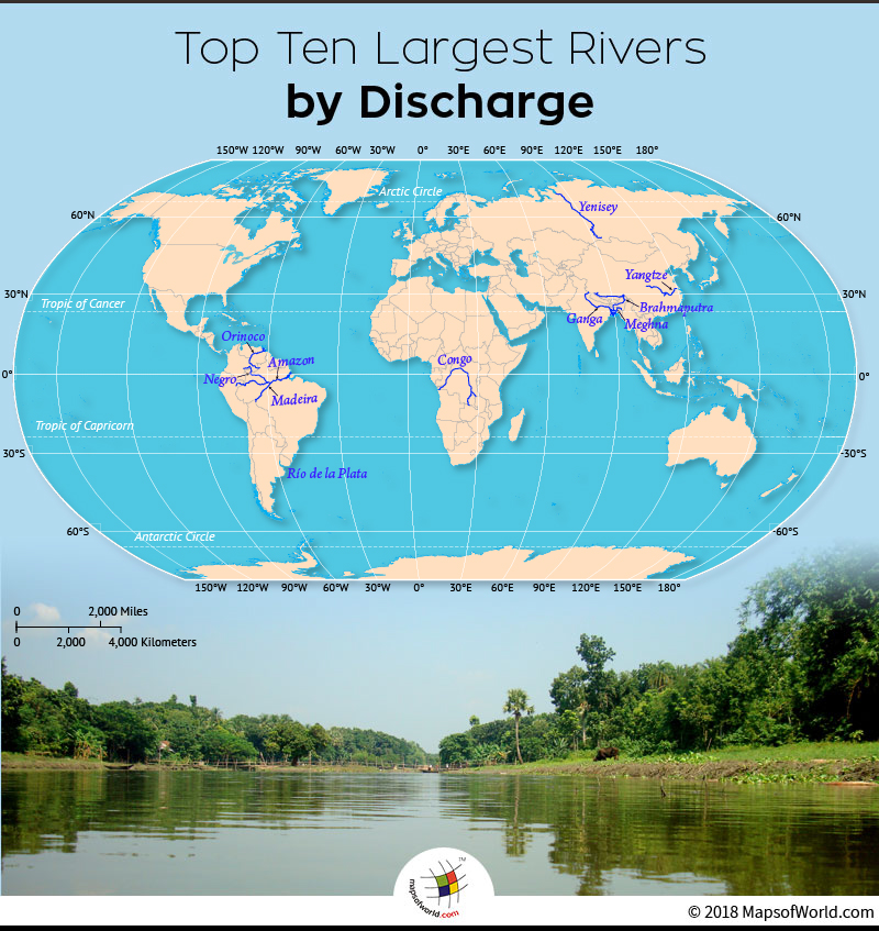
Below given table mentions the largest rivers by discharge and their drainage areas:
| Continent | River | Length (Miles) | Average discharge (US gallon / minute) |
|---|---|---|---|
| S. America | Amazon | 3,976 | 3.31E+009 |
| Africa | Congo | 2,716 | 6.53E+008 |
| S. America | Orinoco | 1,330 | 6.34E+008 |
| Asia | Ganges – Brahmaputra- Meghna | 3,371 | 6.04E+008 |
| S. America | Madeira | 2,100 | 4.95E+008 |
| Asia | Yangtze (Chang Jiang) | 3,988 | 4.78E+008 |
| S. America | Negro | 1,390 | 4.50E+008 |
| S. America | Río de la Plata | 180 | 3.49E+008 |
| Asia | Brahmaputra | 2,391 | 3.14E+008 |
| Asia | Yenisei | 2,136 | 3.11E+008 |
Know more:
Related maps: