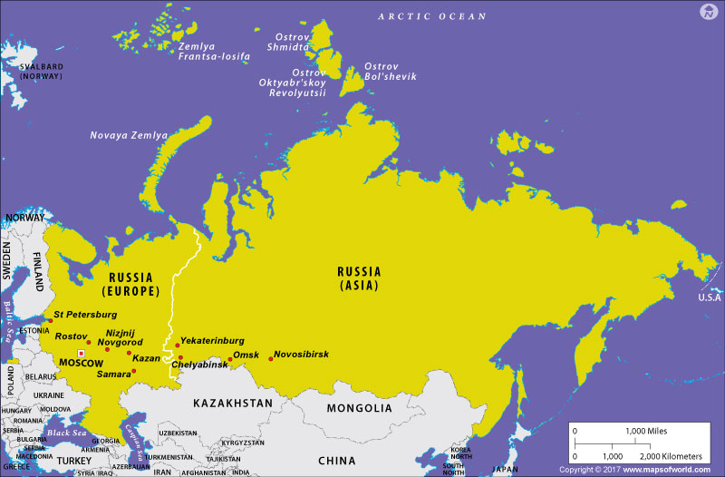
- Political Maps: These maps showcase political boundaries, such as countries, states, and cities, along with capitals and major features. They help us understand the political divisions and territorial boundaries. For a visual representation, check out the following political maps example.
- Physical Maps: Physical maps depict the physical features of an area, including landforms, mountains, rivers, and oceans. They provide insights into the natural geography and terrain of a region. For a visual representation, check out the following physical maps example.
- World Physical Map
- North America Physical Map
- Europe Physical Map
- Africa Physical Map
- Asia Physical Map
- Economic Maps: Economic maps focus on displaying economic activities, such as natural resources, industries, trade routes, and transportation networks. They help us analyze economic patterns and resource distribution. For a visual representation, check out an economic map example.
- Topographic Maps: Topographic maps represent the elevation and surface features of an area using contour lines. They provide detailed information about mountains, valleys, and other physical features, aiding in navigation and outdoor activities. For a visual representation, check out the following topographic maps example.
- Climatic Maps: Climatic maps illustrate climate patterns, including temperature, precipitation, and weather conditions. They help us understand climatic zones and variations across different regions. For a visual representation, check out a climatic map example.
- Thematic Maps: Thematic maps focus on specific themes or topics, such as population density, land use, vegetation, or cultural phenomena. They provide specialized information and allow for in-depth analysis. For a visual representation, check out the following thematic maps example.
- Road Maps: Road maps are designed for navigation, highlighting roads, highways, and transportation networks. They assist in planning routes and finding directions for travel. For a visual representation, check out the following road maps example.
- Digital Maps: Digital maps are interactive and dynamic, accessible through electronic devices. They offer customizable features, including zooming, layering, and real-time updates, enhancing the user experience
- Blank Maps: Blank maps provide a framework without any pre-drawn features. They allow users to add their own information, such as labeling countries, cities, or physical features. For a visual representation, check out the following blank maps example.
- Location Maps: Location maps focus on highlighting specific places or points of interest within a broader context, providing an overview of their spatial relationship. For a visual representation, check out the location maps example.
- Projection Maps: Projection maps display the curved surface of the Earth on a flat surface, using different map projections. They help minimize distortions and maintain accuracy in depicting spatial relationships. For a visual representation, check out the following projection maps example.
Related Links:
Last Updated : June 05, 2023