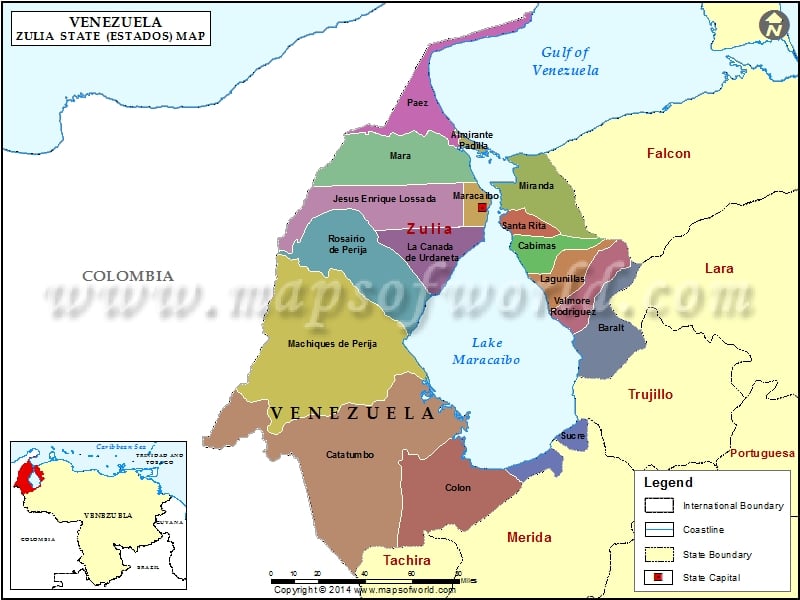
Zulia is a Venezuela state in the northwestern region of the country. Zulia state in Venezuela surrounds Lake Maracaibo. This Venezuelan state covers an area of over 63,000 sq. km. and has the Gulf of Venezuela to its north and Colombia on the west. This state having a population of approximately 3,052,000, has its capital in Maracaibo.
Zulia is surrounded by Falcon in the north east, Lara and Trujilo in the east, Merida in the south east and Tachira in the south.
Zulia Climate
The relief of Zulia in Venezuela is flat lowland. The northern division of the state is hot and dry, while the southern part is hot and wet. The climate is predominantly tropical, with the average maximum temperature of 33º C and the average minimum temperature of 26º C. The wet season in Zulia extends from May to November, and the annual rainfall measures up to about 50 cm.
Zulia Attractions
Zulia attractions range from lakes and beaches to churches, monuments and cities. Maracaibo, Cabimas, and Ciudad Ojeda are important cities in this state. Lake Maracaibo is the largest lake in Venezuela. Cotorerra and Caimare Chico are two notable beaches of this Venezuelan state.
Maracaibo and Lake Maracaibo
Maracaibo named after Lake Maracaibo is the state capital founded in 1529 by a German governor Ambrosio Alfinger. Maracaibo is well known for its imposing churches, magnificent monuments, golden beaches, and Lake Maracaibo.
- Lake Maracaibo covering an area of almost 13,000 sq. km., is not only the largest lake in Venezuela, but also Zulia’s main waterway. This lake is of immense commercial value to the state’s economy.
- The Chiquinquira Basilica built in 1686, was a reed covered chapel initially. Later, it became more famous as Church of San Juan de Dios.
- Maracaibo Bullring built is 1972 accommodates 15,000 spectators. Chiquinquira Fair held in honor of Saint Chiquinquira between November 15 and 18 is an important occasion in Zulia.
- General Rafael Urdaneta Bridge measuring 8.67 km across the Maracaibo Lake connecting west Zulia to east Zulia and rest of Venezuela, is one of the magnificent concrete constructions in Venezuela.
Other Zulia attractions include Manzanillo archaeological site, Capitulacion House, Las Aguilas Palace, Rafael Urdaneta Park, La Marina Park and so on.
Municipalities of Zulia State (Estado) |
| Municipality | Capital | Population | Area(km.²) |
|---|---|---|---|
| Almirante Padilla | El Toro | 9,030 | 151 |
| Baralt | San Timoteo | 73,907 | 2,211 |
| Cabimas | Cabimas | 223,484 | 767 |
| Catatumbo | Encontrados | 31,780 | 5,225 |
| Colón | San Carlos del Zulia | 107,821 | 3,368 |
| Francisco Javier Pulgar | Pueblo Nuevo (El Chivo) | 29,208 | 800 |
| Jesús Enrique Lossada | La Concepción | 83,468 | 3,533 |
| Jesús María Semprún | Casigua El Cubo | 23,972 | 6,003 |
| La Cañada de Urdaneta | Concepción | 61,525 | 2,073 |
| Lagunillas | Ciudad Ojeda | 169,400 | 1,024 |
| Machiques de Perijá | Machiques | 93,154 | 9,493 |
| Mara | San Rafael del Moján | 155,918 | 3,588 |
| Maracaibo | Maracaibo | 1,219,927 | 478 |
| Miranda | Los Puertos de Altagracia | 78,949 | 2,255 |
| Páez | Sinamaica | 24,309 | 2,370 |
| Rosario de Perijá | La Villa del Rosario | 67,712 | 3,914 |
| San Francisco | San Francisco | 351,958 | 126 |
| Santa Rita | Santa Rita | 44,119 | 578 |
| Simón Bolívar | Tía Juana | 36,225 | 107 |
| Sucre | Bobures | 50,708 | 874 |
| Valmore Rodríguez | Bachaquero | 47,105 | 1,292 |

 Maracaibo