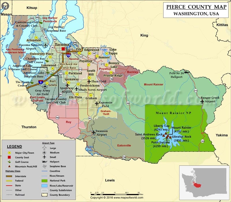
Check this Washington County Map to locate all the state’s counties in Washington Map.
Founded on December 22, 1852, Pierce County is located in the Puget Sound area in Western Washington. The county is named for U.S. President Franklin Pierce. The second most populous county in the state of Washington, behind King County. Tacoma, the county seat, is the third largest in the state. Regionally known as the “City of Destiny,” Tacoma is a major financial center in the South Sound region.
The county covers a total area of 1,806 square miles, south of the Seattle Metropolitan Area. The highest point in Washington, Mount Rainier in the Cascade Range at 4,392 meters, is located in Pierce County. Popular among mountaineers, this volcanic summit is the centerpiece of the fifth national park in the United States. The 236,381-acre expanse of Mount Rainier National Park features valleys, waterfalls, sub-alpine meadows, old-growth forests, and glaciers. The county is home to the Clearwater Wilderness area. Events in Pierce County such as Daffodil Festival & Parade in April and the Washington State Fair in September draw in a large number of visitors.
Seattle-Tacoma International Airport, 22 miles north of downtown Tacoma, is the primary gateway in the region. The Port of Tacoma, the sixth busiest container port in North America, plays a key trade role in the Pacific Northwest. Interstate 5 is the major corridor in the county. It connects Tacoma with Olympia and Seattle. State Route 410, SR 16, and SR 7 are secondary highways in Pierce County. Amtrak Station in Tacoma is served by the Cascades route.
More maps of Pierce County
- Pierce County Map, Wisconsin
- Pierce County Map, North Dakota
- Pierce County Map, Nebraska
- Pierce County Map, Georgia
Facts about Pierce county in Washington |
|
|---|---|
| County Name | Pierce county |
| Population | 8,31,928 |
| Founded | 22 December 1852 |
| Area | 1,806 sq mi (4,678 sq km) |
| Land Area | 1,670 sq mi (4,325 km2) |
| Water Area | 137 sq mi (355 sq km), 7.6% |
| Largest City | Tacoma |
| Cities | Bonney Lake, Fife, DuPont, Ruston, Carbonado, Edgewood, Steilacoom, Sumner, Puyallup, Lakewood, University Place, Eatonville, Roy, South Prairie, Gig Harbor, Orting, Buckley, Fircrest, Wilkeson, Kapowsin, Browns Point, Purdy, Wauna, Home, North Puyallup, |
| County Seat | Tacoma |
| Timezone | Pacific: UTC-8/-7 |
 Wall Maps