- North Carolina Counties - North Carolina County Map, Map of North Carolina Counties
- Major Cities of North Carolina - Raleigh, Charlotte
- Neighbouring States - Virginia, Tennessee, Georgia, South Carolina
- Regional Maps - Map of USA
- Other North Carolina Maps - North Carolina Map, Where is North Carolina, North Carolina Physical Map, North Carolina Lat Long Map, North Carolina Zip Code Map, North Carolina Area Code Map, North Carolina National Parks Map
About North Carolina Airports:
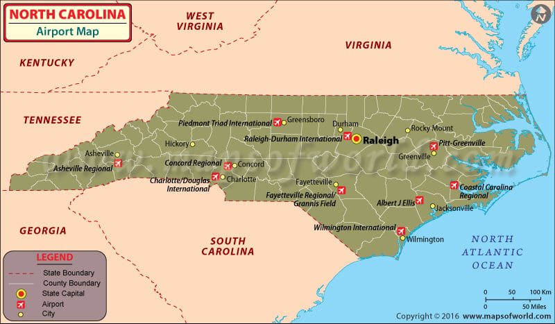
There are 114 airports in North Carolina. These airports play an important role in the overall communications system of the state – both locally and internationally. The airports are also known for their helpful attitude toward the passengers. View above Map of North Carolina with all the Airports in state
Top Airports in North Carolina
Asheville Regional Airport: The Asheville Regional Airport can be described as a Class C airport. It is located near Interstate 40 and Interstate 26 in Fletcher, North California. It lies 9 miles to the south of Asheville and is owned by the city. In 2009 this airport saw a 4.1% rise in passenger count.
Charlotte/Douglas International Airport: The Charlotte/Douglas International Airport is a civil-military international airport. It is located in Charlotte and was set up in 1935 as the Charlotte Municipal Airport. It was renamed as Douglas Municipal Airport in 1954 after Ben Elbert Douglas Sr., the former mayor of Charlotte. The airport got its present name in 1992 and is now the biggest air hub in USA.
Fayetteville Regional Airport: Fayetteville Regional Airport is also called the Grannis Field. It is a public airport and is located three miles south from Fayetteville, which is a central business district and located in Cumberland County. There are two runways at the airport and two terminals, which are used for commercial aviation. One terminal is separately used for general aviation traffic.
Piedmont Triad International Airport: The Piedmont Triad International Airport is located to the west of Greensboro and serves the city in addition to High Point and Winston Salem. The whole Piedmont Triad region in North Carolina is also benefited by this airport, which has 3 runways. The third runway was inaugurated on 27th January 2010.
Pitt-Greenville Airport: The Pitt-Greenville Airport is a public airport, which is located two miles to the north of the East Carolina University and Greenville, which is a central business district in Pitt County. It covers almost 872 acres and has three runways. It is mainly used for general aviation but is served by a commercial airline as well.
Albert J. Ellis Airport: The Albert J. Ellis Airport is owned by the Onslow County in North Carolina. It is positioned in Richlands and is 10 nautical miles west to Jacksonville, which is a central business district. The Marine Corps Base Camp Lejeune is close to the airport as well. There are three gates and a runway at the airport.
Maps of Major Airports in North Carolina
- Asheville Regional Airport Map
- Charlotte Douglas International Airport Map
- Fayetteville Regional Airport Map
- Piedmont Triad International Airport Map
- Pitt Greenville Airport Map
- Albert J. Ellis Airport Map
- Coastal Carolina Regional Airport Map
- Raleigh Durham International Airport Map
- Wilmington International Airport Map
| Airport Name | Airport Code | City | Coordinates |
|---|---|---|---|
| Asheville Regional Airport | AVL | Asheville | 35°26′10″N 082°32′30″W |
| Charlotte Douglas International Airport | CLT | Charlotte metropolitan area | 35°12′50″N 080°56′35″W |
| Fayetteville Regional Airport | FAY | Fayetteville | 34°59′28″N 078°52′49″W |
| Piedmont Triad International Airport | GSO | Greensboro | 36°05′52″N 79°56′14″W |
| Pitt-Greenville Airport | PGV | Greenville | 35°38′07″N 77°23′07″W |
| Albert J. Ellis Airport | OAJ | Jacksonville | 34°49′45″N 077°36′44″W |
| Coastal Carolina Regional Airport | EWN | New Bern | 35°04′23″N 77°02′35″W |
| Raleigh-Durham International Airport | RDU | Raleigh | 35°52′40″N 078°47′15″W |
| Wilmington International Airport | ILM | Wilmington | 34°16′14″N 077°54′09″W |
| Horace Williams Airport | — | Chapel Hill | 35°56′06″N 079°03′57″W |
| Wilgrove Air Park | QWG | Charlotte | 35°12′50″N 080°40′12″W |
| Wilson’s Airport | — | Hickory | 35°39′07″N 081°21′28″W |
| Sky Manor Airport | — | Jacksonville | 34°43′01″N 077°35′32″W |
| Shiflet Field | — | Marion | 35°43′14″N 082°00′35″W |
| Twin Lakes Airport | — | Mocksville | 35°54′54″N 080°27′25″W |
| Pink Hill Airport | — | Pink Hill | 35°03′03″N 077°44′10″W |
| Eagles Nest Airport | — | Potters Hill | 34°58′52″N 077°41′59″W |
 Wall Maps