942
Mountain Peaks in Winnebago County
| Mountain Peak/Hill | Elevation [Meter] |
|---|---|
| Lookout Point | 244 |
| Turtle Mound | 219 |
More Maps of Winnebago County
Airports in Winnebago County
| Airport Name |
|---|
| Atwood Heliport |
| Beloit Airport |
| Blackhawk Farms Inc Airport |
| Carlson RLA Restricted Landing Area |
| Chicago Rockford International Airport |
| Cottonwood Airport |
| Darrington Airport |
| Durand Ambulance Service Heliport |
| Early – Merkel Field |
| Harry D Fenton Airport |
| Ingersoll Heliport |
| Kramer Airport |
| Lz Fairwinds Airport |
| Mc Cartney Airport |
| Mc Curdy Airport |
| Mercy Health Center Heliport |
| Mercy Health Center Heliport |
| O’Connor Field |
| Olson Heliport |
| Pecatonica Fire Protection District Heliport |
| Severson Airport |
| Sills-Anderson Heliport |
| Sills-Anderson Heliport |
| St Anthony Medical Center Heliport |
| Swedish American Heliport |
| Triple J Airport |
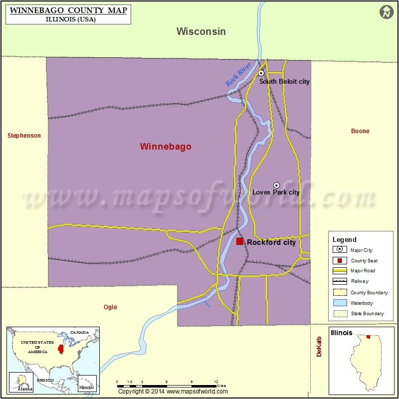
Cities in Winnebago County
| City | Population | Latitude | Longitude |
|---|---|---|---|
| Cherry Valley village | 3162 | 42.222351 | -88.971419 |
| Durand village | 1443 | 42.434174 | -89.326488 |
| Lake Summerset | 2048 | 42.452066 | -89.398376 |
| Loves Park city | 23996 | 42.336683 | -88.998301 |
| Machesney Park village | 23499 | 42.366638 | -89.026578 |
| New Milford village | 697 | 42.177684 | -89.065093 |
| Pecatonica village | 2195 | 42.308576 | -89.357805 |
| Rockford city | 152871 | 42.263318 | -89.062596 |
| Rockton village | 7685 | 42.450054 | -89.063104 |
| Roscoe village | 10785 | 42.425303 | -89.008348 |
| South Beloit city | 7892 | 42.4821 | -89.025052 |
| Winnebago village | 3101 | 42.267137 | -89.2338 |
Golf Courses in Winnebago County
| Name of Golf Course | Latitude | Longitude |
|---|---|---|
| Aldeen Golf Course-Rockford | 42.291118 | -88.985627 |
| Alpine Hills Golf Club-Rockford | 42.25859 | -89.031154 |
| Atwood Homestead Golf Course-Rockford | 42.389915 | -89.0594 |
| Barwood Golf Course-Rockton | 42.42463 | -89.077987 |
| Elliot Golf Course-Rockford | 42.263082 | -88.960144 |
| Forest Hills Country Club-Rockford | 42.302335 | -89.050645 |
| Ingersoll Golf Course-Rockford | 42.276065 | -89.15164 |
| Ledges Golf Course-Roscoe | 42.444477 | -88.977636 |
| Macktown Golf Course-Rockton | 42.444885 | -89.082228 |
| Mauh Nah Tee See Country Club-Rockford | 42.281929 | -89.015679 |
| Red Barn Golf Course-Rockton | 42.438518 | -89.075766 |
| Rockford Country Club-Rockford | 42.299654 | -89.06695 |
| Sandy Hollow Golf Course-Rockford | 42.223669 | -89.054391 |
| Sinnissippi Park Golf Course-Rockford | 42.282472 | -89.068918 |
| Sugar River Greens-Rockton | 42.478581 | -89.182281 |
| Westlake Village-Winnebago | 42.309245 | -89.289979 |
 Wall Maps