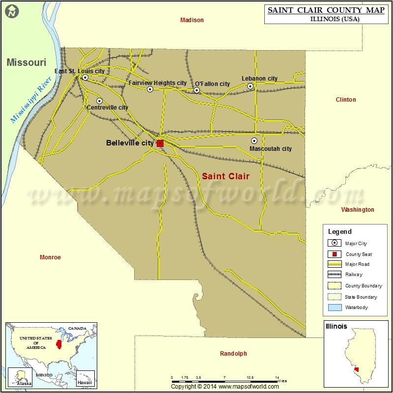
1.2K
Mountain Peaks in St. Clair County
| Mountain Peak/Hill | Elevation [Meter] |
|---|---|
| Berger Hill | 171 |
| Clarks Mound | 196 |
| Dutch Hill | 150 |
| Emerald Mound | 158 |
| Haubers Hill | 166 |
| Oklahoma Hill | 126 |
| Point Lookout | 145 |
| Rattlesnake Mound | 131 |
| Turkey Hill | 187 |
More Maps of St Clair County
Airports in St. Clair County
| Airport Name |
|---|
| Aero Estates Airport |
| Bickel Airport |
| Buehler Airport |
| Harold Emmerich Airport |
| Heitman Aerdrome Airport |
| Kenneth Hall Regional Hospital Heliport |
| Lindauer Airport |
| Memorial Hospital Heliport |
| Schaller Airport |
| Scott AFB/Midamerica Airport |
| St Elizabeth’s Hospital Heliport |
| St Louis Downtown Airport |
| Wildy Field |
Cities in St. Clair County
| City | Population | Latitude | Longitude |
|---|---|---|---|
| Alorton village | 2002 | 38.584905 | -90.113749 |
| Belleville city | 44478 | 38.514849 | -89.986359 |
| Brooklyn village | 749 | 38.654395 | -90.167911 |
| Cahokia village | 15241 | 38.564829 | -90.177475 |
| Caseyville village | 4245 | 38.629883 | -90.033844 |
| Centreville city | 5309 | 38.579888 | -90.103292 |
| Darmstadt | 68 | 38.319013 | -89.728803 |
| Dupo village | 4138 | 38.517696 | -90.208112 |
| East Carondelet village | 499 | 38.537382 | -90.242832 |
| East St. Louis city | 27006 | 38.61532 | -90.130414 |
| Fairmont City village | 2635 | 38.650432 | -90.101451 |
| Fairview Heights city | 17078 | 38.597363 | -90.005358 |
| Fayetteville village | 366 | 38.378047 | -89.797019 |
| Floraville | 53 | 38.376284 | -90.055345 |
| Freeburg village | 4354 | 38.440049 | -89.916256 |
| Lebanon city | 4418 | 38.602392 | -89.812241 |
| Lenzburg village | 521 | 38.285208 | -89.81828 |
| Marissa village | 1979 | 38.253449 | -89.758303 |
| Mascoutah city | 7483 | 38.519268 | -89.804252 |
| Millstadt village | 4011 | 38.459421 | -90.083975 |
| New Athens village | 2054 | 38.318465 | -89.875575 |
| O’Fallon city | 28281 | 38.596173 | -89.915211 |
| Paderborn | 43 | 38.359478 | -90.046375 |
| Rentchler | 34 | 38.491905 | -89.869049 |
| Sauget village | 159 | 38.586551 | -90.163456 |
| Scott AFB | 3612 | 38.541252 | -89.852784 |
| Shiloh village | 12651 | 38.553947 | -89.915798 |
| Smithton village | 3693 | 38.414034 | -89.991175 |
| St. Libory village | 615 | 38.363228 | -89.712785 |
| Summerfield village | 451 | 38.596557 | -89.74688 |
| Swansea village | 13430 | 38.550256 | -89.985973 |
| Washington Park village | 4196 | 38.627981 | -90.092412 |
Golf Courses in St. Clair County
| Name of Golf Course | Latitude | Longitude |
|---|---|---|
| Cardinal Creek Golf Course-Scott Afb | 38.551985 | -89.857065 |
| Clinton Hill Country Club-Swansea | 38.553029 | -89.96613 |
| Elmwood Golf Course-Belleville | 38.540886 | -90.092718 |
| Fairfield Golf Club-Columbia | 38.450621 | -90.168267 |
| Far Oaks Golf Club-Caseyville | 38.62337 | -89.966323 |
| Grand Marais Golf Course-East Saint Louis | 38.600073 | -90.094124 |
| Indian Mounds Golf Club-Fairmont City | 38.659496 | -90.091637 |
| Locust Hills Golf Club-Lebanon | 38.600719 | -89.820743 |
| Mascoutah Country Club-Mascoutah | 38.49197 | -89.817729 |
| Saint Clair Country Club-Belleville | 38.562248 | -90.05018 |
| Stonewolf Golf Club-Fairview Heights | 38.617047 | -89.990517 |
| Tamarack Country Club-O Fallon | 38.566042 | -89.909947 |
| The Bridges Golf Club-Columbia | 38.48305 | -90.203662 |
| The Orchards Golf Club-Belleville | 38.486362 | -89.924887 |
| The Prairies-Cahokia | 38.555464 | -90.176947 |
| Triple Lakes Golf Course-Millstadt | 38.476065 | -90.147101 |
| White Oak Golf Course-Marissa | 38.233476 | -89.726412 |
| Yorktown Golf Complex-Belleville | 38.538875 | -89.944468 |
 Wall Maps