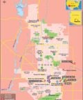


US Interstate 17 highway Map
Interstate 17, popularly abbreviated as I-17, is situated within the US state of Arizona. Its southern terminus lies within Phoenix at Interstate 10. Also, its northern terminus lies in Flagstaff, at the interstate 40 highway. A major portion of I-17 is popularly known as the Arizona Veterans Highway. Also, in the Phoenix metropolitan area, the interstate 17 is known as the Black Canyon Freeway.
The exists of Interstate 17 highway provide a scenic view and have become a hot favorite among mountaineers. Since I-17 is higher more than a mile in altitude between Phoenix and Flagstaff, the US highway has become one of the most beautiful Interstate Highways in the US.
Extent of I-17 Highway
Also known as the Black Canyon Freeway, Interstate 17 stretches from the northern end of the Phoenix Metropolitan Area to a point 2.2 miles south of Interstate 10. Also, I-17 gets renamed to Maricopa Freeway towards the southern terminus at the latter Interstate 10 junction.While the Interstate 17 is closed to bicycles and pedestrians towards the south of Pioneer Road in the Anthem area, the US highway is open to them towards the north of the same point. It starts at milepost 194 instead of milepost zero.
States and cities along I-17 Highway
- Arizona: Flagstaff, Phoenix
Restaurants along Interstate-17 Highway
Here is a list of few great restaurants along Interstate-17 Highway:- Carolina’s Mexican Food
- Delicious Deliveries
- Alice Cooper’s Town
- Comedor Guadalajara
- George and Dragon
Attractions along I-17 Highway
Some of the renowned tourist attractions along I-17 Highway include:- Icehouse
- State Senate
- Flo Rians Gallery
- Chase Field
- Phoenix Greyhound Park
Route of Interstate Highway No.17 |
| State | Entry Point | Exit Point | Length |
|---|---|---|---|
| Arizona | Phoenix, AZ | Flagstaff, AZ | 145.76 mi (234.58 km) |
| Total Length | 145.76 mi (234.58 km) |
Last Updated Date: April 15, 2017