Solomon Islands Earthquakes |
 |
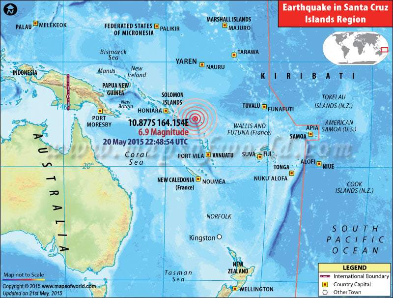
Map showing the epicentre of earthquake near Santa Cruz islands (Solomon Islands) |
Earthquakes in Santa Cruz Islands (Solomon Islands)
M6.9 Earthquake in Santa Cruz Islands on May 20, 2015

| Description :Map showing the epicentre of earthquake near Santa Cruz islands (Solomon Islands) |
| Disclaimer |
*We specifically create maps that have a magnitude of 6 or more on the Richter Scale.
| Recently Earthquakes in (Santa Cruz Islands) Solomon Islands |
| Magnitude | Earthquake Location | Country | Event Date | Timing |
|---|---|---|---|---|
| M 6.9 | 184km W of Lata | Solomon Islands | (Wednesday) May 20, 2015 | 22:48:54 UTC |
| M 7.1 | 26km S of Lata | Solomon Islands | (Friday)8th Feb 2013 | 11:12:12 UTC |
| M 6.6 | 36km SSW of Lata | Solomon Islands | (Thursday)7th Feb 2013 | 18:59:16 UTC |
| M 6.3 | 144km W of Lata | Solomon Islands | (Wednesday)6th Feb 2013 | 06:35:19 UTC |
| M 7.0 | 27km NNW of Lata | Solomon Islands | (Wednesday)6th Feb 2013 | 01:54:15 UTC |
| M 6.4 | 114km WSW of Lata | Solomon Islands | (Wednesday)6th Feb 2013 | 01:23:19 UTC |
| M 8.0 | 76km W of Lata | Solomon Islands | (Wednesday)6th Feb 2013 | 01:12:27 UTC |
| M 6.3 | 70km WSW of Lata | Solomon Islands | (Wednesday)6th Feb 2013 | 00:07:22 UTC |
| M 6.4 | 67km SW of Lata | Solomon Islands | (Friday)1st Feb 2013 | 22:18:35 UTC |
| M 6.3 | 47km WSW of Lata | Solomon Islands | (Friday)1st Feb 2013 | 22:16:36 UTC |
