- Qatar Provinces and Cities - Ar Rayyan, Doha, Umm Said, Umm Salal Ali, Umm Salal Muhammad
- Qatar Provinces - Al Daayen, Al Khor and Al Thakhira, Al Rayyan, Al Wakra, Madinat Al Shamal
- Neighboring Countries - Bahrain, United Arab Emirates, Saudi Arabia, Oman, Kuwait
- Continent And Regions - Asia Map
- Other Qatar Maps - Qatar Map, Where is Qatar, Qatar Blank Map, Qatar Road Map, Qatar Cities Map, Qatar Physical Map, Qatar Flag
Geographical Feature of Qatar
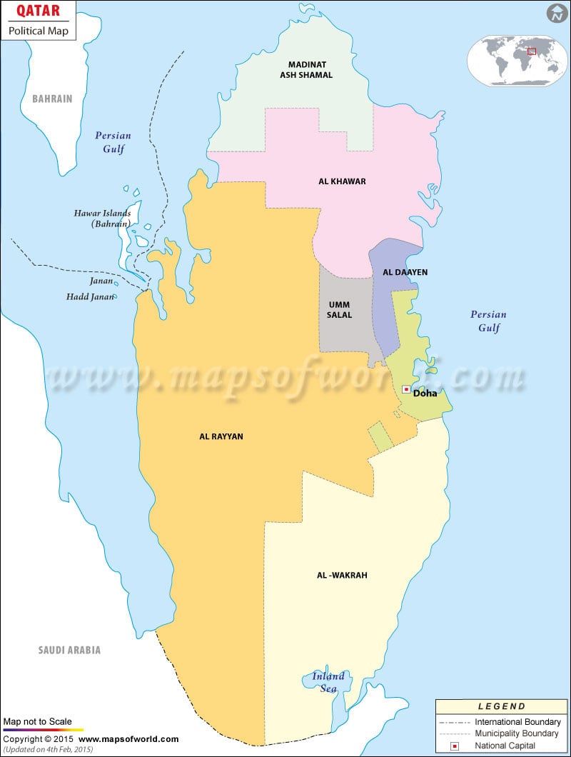
The political map of Qatar points the country in the Middle East, sharing its border with United Arab Emirates and Kingdom of Saudi Arabia. The country is a peninsula jutting out in the Persian Gulf. The geographical coordinates of the country are 25° 30‘; North latitude and 51°15‘ East longitude. The total land area of Qatar is 11,437 square kilometers. 563 kilometers make up the coastline of the country. The highest and the lowest point of the country are Quryan Abu al Bawl situated at 103 meters above sea level and Persian Gulf respectively.
Administrative Divisions of Qatar
The administrative divisions featuring on the online Qatar political map is colored individually for the convenience of the browsers. The broken line on the map of Qatar clearly differentiates the administrative divisions. The administrative divisions are:
- Ash Shamal
- Al Ghuwayriyah
- Al Khawr
- Al Jumayliyah
- Umm Salal
- Ar Rayyan
- Ad Dawah
- Al Jumayliyah
- Al Wakrah
- Jarayan al Batnah
Capital of Qatar
Doha is the capital of Qatar. The geographical coordinates of the city are 25° 17‘ 12″ North latitude and 51° 31‘ 60″ East longitude. The city stands at an altitude of 13 meters above sea level. Al Bida’ ash Sharqiyah, ar Rumaylah and As sawq are the neighboring cities of Doha. The city’s airports are the main gateways to the city. They are Doha International, Shaikh Isa, Bahrain International and Al Udeid Ab.
| Municipality | Population | Area(km.²) | Area(mi.²) |
|---|---|---|---|
| Ad Dawhah | 796,947 | 234 | 90 |
| Al Daayen | 43,176 | 236 | 91 |
| Al Khawr | 193,983 | 1,551 | 599 |
| Al Wakrah | 141,222 | 2,520 | 973 |
| Ar Rayyan | 455,623 | 5,818 | 2,246 |
| Madinat ach Shamal | 7,975 | 902 | 348 |
| Umm Salal | 60,509 | 310 | 120 |
| 7 municipalities | 1,699,435 | 11,571 | 4,467 |
| Municipality | Population | Area(km.²) | Area(mi.²) | Capital |
|---|---|---|---|---|
| Ad Dawhah | 339,847 | 132 | 51 | Doha |
| Al Ghuwariyah | 2,159 | 622 | 240 | Al Ghuwayriyah |
| Al Jumaliyah | 10,303 | 2,565 | 990 | Al Jumayliyah |
| Al Khawr | 31,547 | 996 | 385 | Al Khawr |
| Al Wakrah | 31,441 | 1,114 | 430 | Al Wakrah |
| Ar Rayyan | 272,860 | 889 | 343 | Ar Rayyan |
| Jariyan al Batnah | 6,678 | 3,715 | 1,434 | Umm Bab |
| Madinat ach Shamal | 4,915 | 901 | 348 | Dukhan |
| Umm Sa’id | 12,674 | Umm Sa’id | ||
| Umm Salal | 31,605 | 493 | 190 | Umm Silal’ait |
| 10 municipalities | 744,029 | 11,427 | 4,412 |

 Qatar Facts