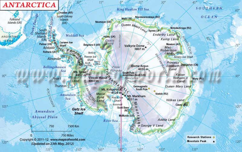
Antarctica physical map also shows that it is surrounded by the Antarctic Ocean, which is a body of water made up of southern portions of Atlantic Ocean, Pacific Ocean, and Indian Ocean.
Detailed map of Antarctica shows that the relief is very difficult to determine, as most of the continent lies under permanent ice sheets. However, the Transantarctic mountains divide Antarctica into two parts - the Western Antarctica and Eastern Antarctica. There are two active volcanoes here - Deception Islands, and the Mt. Erebus, and many other non-active ones. It has more than 70 lakes that lie under the surface of the continental ice-sheets. To learn more about Antarctica, check our
Map of Antarctica section.
As it was a part of the Gondwana landmass, Antarctica has reserves of coal, hydrocarbons, Gold, Platinum, iron-ore, etc.
Detailed map of Antarctica depicts that 98 per cent of the surface is covered with permanent ice-sheets. Although precipitation is quite low, 90 percent of the freshwater reserve of the world is locked up here. The moving ice-sheets under the influence of gravity are called glaciers. In Antarctica the glaciers move down in five major drainage systems. When they reach the end of the continent, they are detached and form icebergs, which gradually melt into the ocean water.
Much of the continent is still unexplored. However, tourism in small scale has developed with the existing research stations. Travel Map of Antarctica can be a very useful tool for tourists planning for Antarctica. Online Antarctica Maps are also available for quick and easy reference.
Antarctica is the fifth largest continent and lies completely in the southern hemisphere and is also known as the
"land of ice" since it is permanently covered with ice sheets. It is the coldest, windiest most remote and most recently discovered continent. It surrounded by the Antarctic Ocean that is a body of water made up of southern portions of Atlantic Ocean, Pacific and Indian Ocean.
The relief is very difficult to determine as most of the continent lies under permanent ice sheets. However, the Transantarctic mountains divide Antarctica into two parts - the Western Antarctica and Eastern Antarctica. There are two active volcanoes here - Deception Islands and the Mt. Erebus, and many other non-active ones. It has more than 70 lakes that lie under the surface of the continental ice-sheets.
As it was a part of the Gondwana landmass, Antarctica has reserves of coal, hydrocarbons, Gold, Platinum, iron-ore, etc.
98% of the surface is covered with permanent ice-sheets. Although precipitation is quite low, 90 percent of the freshwater reserve of the world is locked up here. The moving ice-sheets under the influence of gravity is called glaciers. In Antarctica the glaciers move down in five major drainage systems. When they the end of the continent, they are detached and forms the icebergs which gradually with time melts in the ocean water.
Last Updated : June 05, 2015


