- Neighboring Countries - Syria, Israel, Jordan
- Continent And Regions - Asia Map
- Other Lebanon Maps - Lebanon Map, Where is Lebanon, Lebanon Blank Map, Lebanon Road Map, Lebanon Rail Map, Lebanon River Map, Lebanon Cities Map, Lebanon Physical Map, Lebanon Flag
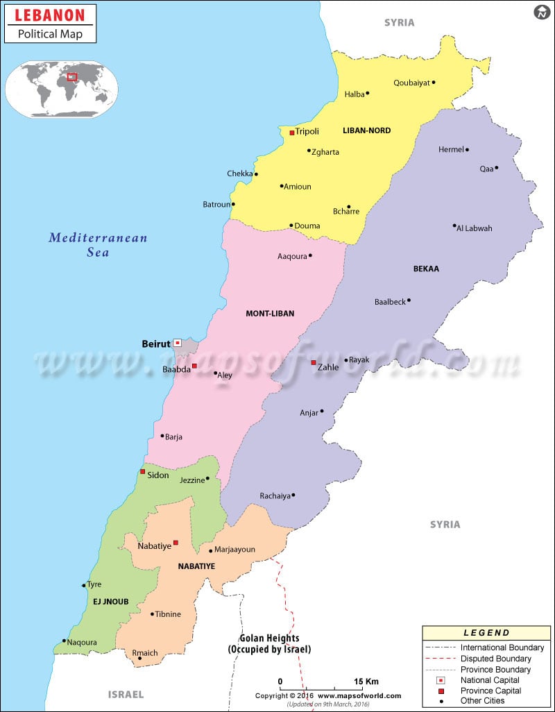
Lebanon political map represents a visual display of the country. Lebanon is bordered by Israel in the south and by Syrian Arab Republic in the north and the east. The governorate boundaries are marked with a violet line while the international boundary is drawn with a black bold line. The online map of Lebanon points out the national capital with a red dot and the governorate capitals with green dots. The coastline of the country is demarcated with a blue line in the map of Lebanon.
Geographical Extent of Lebanon
The geographical coordinates of the country are 33° 50´ North latitude and 35°50´ East longitude. Israel and Syria are the neighboring countries of Lebanon as shown in the Lebanon map. The western part of the country borders with Mediterranean Sea. The land area is 10,230 square kilometers of the total area of 10, 400 square kilometers. The area covered by water bodies comprise of 170 square kilometers. 225 kilometers make up the coastline of the country and is marked with a blue line as shown on the Lebanon map. Qurnat as Sawda is the highest point located at 3,088 meters above sea level while the lowest point is Mediterranean Sea.
Governorate Boundaries
Violet lines outline the governorate boundaries of Lebanon. The capitals of the governorates are denoted with green squares. The names of the governorates can be easily identified as they are typed in bold fonts than the governorate capitals and important cities. Following are the names of the governorates and their capitals:
- Liban-Nord- Tripoli
- Beqaa- Zahle
- Nabatiye- Nabatiye
- Ej Jnoub- Jezzine
- Mont-Liban- Baabda
- Beirut- Beirut
Important Cities in Lebanon Map
Some of the important cities demarcated by black dots featuring on the printable map of Lebanon are:
|
|
National Capital of Lebanon
The national capital of Lebanon is Beirut. The city is situated at an altitude of 55 meters above sea level. The geographic coordinates of the city are 33°52´19” North latitude and 35°30´35” East longitude. Some of the neighboring cities are:
- Ra’s an Nab’an
- Tahwitat an Nahr
- Mar Nahra
- Al Nasirah
- Al Bashurah
- Al Mazre’ah
- Furn ash Shubbak
- Al Ashrafiyah
Beirut International, Rayak, Mezze and Mahanaim I Ben Yaakov are the main airports of the city serving as gateways to the city.
| Province | Population | Area(km.²) | Area(mi.²) | Capital | Arabic name |
|---|---|---|---|---|---|
| Aakkar | 776 | 300 | |||
| An Nabaţiyah | 221,846 | 1,058 | 408 | An Nabatiyah at Tahta | An Nabatiyah |
| Baalbek-Hermel | 3,009 | 1,162 | |||
| Beirut | 390,503 | 18 | 7 | Bayrut (Beirut) | Bayrut |
| Beqaa | 471,209 | 1,271 | 491 | Zahlah | Al Biqa |
| Mount Lebanon | 1,501,570 | 1,950 | 753 | B`abda | Jabal Lubnan |
| North Lebanon | 768,709 | 1,205 | 465 | Ţarabulus (Tripoli) | Ash Shamal |
| South Lebanon | 401,197 | 943 | 364 | Sayda (Sidon) | Al Janub |
| 8 provinces | 3,755,034 | 10,230 | 3,950 |
 Wall Maps
 Lebanon Weather