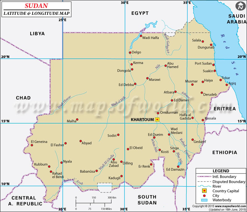
Sudan latitude and longitude co-ordinates position it on the northern side of the African continent beside the Red Sea.
Further, Sudan's latitude and longitude co-ordinates give it a position just in between Egypt and Eritrea. The latitude and longitude denominations of Sudan are 15°00 N and 30°00 E respectively. Sudan's latitude and longitude denominations provide it with an area which is approximately 2,505,810 sq km. The latitude and longitude co-ordinates of Sudan's capital Khartoum is 15°36N and 32°32 E respectively.
The country of Sudan, because of its latitude and longitude denominations experiences a climate which is marked by tropical weather in the south, dry, desert like temperatures in the north while rains are experienced in the months between April to November.
| Locations |
Latitude |
Longitude |
| Abay/Nil el Azraq | 15°38'N | 32°31'E |
Abay/Nil el Azraq | 15°38'N | 32°31'E |
Abu Hamed | 19°32'N | 33°13'E |
Abu Zabad | 12°25'N | 29°10'E |
Adarama | 17°10'N | 34°52'E |
Al Junaynah | 13°27'N | 22°45'E |
Amadi | 05°29'N | 30°25'E |
Arab, Bahrel | 09°00'N | 29°30'E |
Atbara, | 17°42'N | 33°59'E |
Atbara, Nahr | 17°40'N | 33°56'E |
Bahrel Ghazal | 07°00'N | 28°00'E |
Berber | 18°00'N | 34°00'E |
Bir Atrun | 18°15'N | 26°40'E |
Blue Nile / Nil el Azraq | 15°38'N | 32°31'E |
Bor | 06°10'N | 31°40'E |
Bur Sudan | 19°32'N | 37°09'E |
Darfur | 13°40'N | 24°00'E |
Delgo | 20°06'N | 30°40'E |
Dongola | 19°09'N | 30°22'E |
Ed Damazin | 11°46'N | 34°21'E |
Ed Debba | 18°00'N | 30°51'E |
Ed Dueim | 14°00'N | 32°10'E |
El Fasher | 13°33'N | 25°26'E |
El Geneina / Al Junaynah | 13°27'N | 22°45'E |
El Istiwa'iya | 05°00'N | 28°00'E |
El Khartum | 15°31'N | 32°45'E |
El Obeid | 13°08'N | 30°10'E |
El Odaiya | 12°08'N | 28°12'E |
El Wuz | 15°05'N | 30°07'E |
En Nahud | 12°45'N | 28°25'E |
Er Rahad | 12°45'N | 30°32'E |
Fifth Cataract | 18°22'N | 33°50'E |
Fourth Cataract | 18°47'N | 32°03'E |
Gedaref | 14°02'N | 35°28'E |
Ghazal, Bahr el | 09°31'N | 30°25'E |
Gogrial | 08°30'N | 28°08'E |
Hadarba, Ras | 22°04'N | 36°51'E |
Haiya | 18°20'N | 36°21'E |
Halaib | 22°12'N | 36°30'E |
Jebel, Bahrel | 09°30'N | 30°25'E |
Juba | 04°50'N | 31°35'E |
Jur, Nahr el | 08°45'N | 29°15'E |
Kadugli | 11°00'N | 29°45'E |
Kajo Kaji | 03°58'N | 31°40'E |
Kapoeta | 04°50'N | 33°35'E |
Kareima | 18°30'N | 31°49'E |
Karora | 17°44'N | 38°15'E |
Kassala | 15°30'N | 36°00'E |
Khartoum / El Khartum | 15°31'N | 32°35'E |
Khashm el Girba | 14°59'N | 35°58'E |
Kordofan | 13°00'N | 29°00'E |
Kosha | 20°50'N | 30°30'E |
Kosti | 13°08'N | 32°43'E |
Kutum | 14°10'N | 24°40'E |
Malakai | 09°33'N | 31°40'E |
Malha | 15°08'N | 25°10'E |
Marra, Djebel | 13°10'N | 24°22'E |
Mongalla | 05°08'N | 31°42'E |
Muhammad Qol | 20°53'N | 37°09'E |
Nil el Abyad | 15°38'N | 32°31'E |
Nil el Azraq | 15°38'N | 32°31'E |
Nubian Desert / Nubiya Es Sahra en | 21°30'N | 33°30'E |
Nubiya Es Sahra en | 21°30'N | 33°30'E |
Nyala | 12°02'N | 24°58'E |
Omdurman | 15°40'N | 32°28'E |
Pibor Post | 06°47'N | 33°03'E |
Port Sudan / Bur Sudan | 19°32'N | 37°09'E |
Raga | 08°28'N | 025°41'E |
Rumbek | 6°54'N | 29°37'E |
Singa | 13°10'N | 33°57'E |
Sinkat | 18°55'N | 36°49'E |
Sobat Nahr | 9°22'N | 31°33'E |
Sodiri | 14°27'N | 29°0'E |
Songo | 9°47'N | 24°21'E |
Tali Post | 5°55'N | 30°44'E |
Toinya | 6°17'N | 29°46'E |
Tonj | 7°20'N | 28°44'E |
Torit | 4°27'N | 32°31'E |
Umm Keddada | 13°33'N | 26°35'E |
Umm Ruwaba | 12°50'N | 31°20'E |
Uweinat Jebel | 21°54'N | 24°58'E |
Wau / Waw | 7°45'N | 28°1'E |
Waw | 7°45'N | 28°1'E |
Yambio | 4°35'N | 28°16'E |
Yei | 4°9'N | 30°40'E |
Zalingei | 12°51'N | 23°29'E |
Last Updated on: May 26th, 2023


