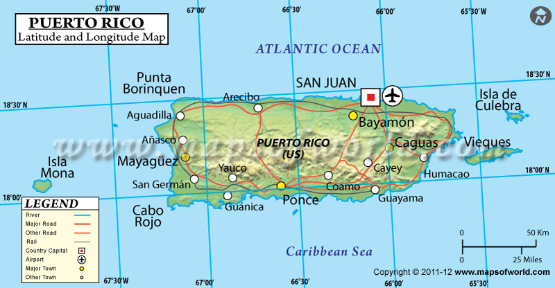
The geographical latitude and longitude of Puerto Rico is 18º 15' N and 66º 30' W respectively. It is located in Caribbean and lies between Caribbean Sea and North Atlantic Ocean. The total area is slightly smaller than three times that of Rhode Island. San Juan, the capital, is located on 18º 28' N and 66º 07' W latitude and longitude respectively. There are 78 municipalities in Puerto Rico and it is one hour ahead of Washington DC during Standard Time.
The total area of Puerto Rico is the coastline extending for 501 kilometers. The terrain of the island is mostly mountainous with coastal belts on the northern part and sandy beaches along the coastal areas. The
climate of Puerto Rico is mainly of tropical marine type and has very little seasonal temperature variations. Hurricanes and periodic droughts are common natural calamities of Puerto Rico. Soil erosion and periodic droughts are the major environmental concerns of Puerto Rico.
| Locations |
Latitude |
Longitude |
| Aguadilla | 18°26'N | 67°10'W |
Bayamon | 18°24'N | 66°10'W |
Caguas | 18°14'N | 66°02'W |
Carolina | 18°23'N | 65°58'W |
Fajardo | 18°20'N | 65°39'W |
Guayama | 17°29'N | 66°07'W |
Mayaguez | 18°12'N | 67°09'W |
Ponce | 18°01'N | 66°37'W |
San Juan | 18°28'N | 66°7'W |
Last Updated on: December 28th, 2016


