Panama Latitude and Longitude Map
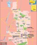
Panama's latitude and longitude is 09° 00' N and 80° 00' W . Below is the map of Panama showing major towns, roads, airports with latitudes and longitudes plotted on it.
Search For Latitude & Longitude Map
Or
Latitude
Longitude
Or
Area
* Put South & West values with minus ( - ) sign.

|

| Description: Find Panama latitude and longitude map showing comprehensive details including cities, roads, towns, airports and much more. | Disclaimer |
Panama is located within the latitude and longitude of 09° 00 N, 80° 00 W. The Republic of Panama is the southernmost country of Central America.
The latitude and longitude of Panama includes 78,200 sq km of total land area. It is marked by a chain of mountains in the west, moderate hills in the interior, and a low range on the east coast. There are extensive forests in the fertile Caribbean area. The climate within this latitude and longitude of Panama is tropical in nature. Here persists a hot, humid and cloudy rainy season from the month of May to January. In this region dry season lasts for very short period, from January to May.
-
Locations Latitude Longitude Aguadulce 08°15'N 80°32'W Almirante 09°10'N 82°30'W Azuero, Pen. de 07°30'N 80°30'W Balboa 08°57'N 79°34'W Baru, Volcan 08°55'N 82°35'W Bocas del Toro 09°15'N 82°20'W Boquete 08°46'N 82°27'W Cebaco, I.de 07°33'N 81°09'W Chepo 09°10'N 79°06'W Chiman 08°45'N 78°40'W Chiriqui, G. de 08°00'N 82°10'W Chiriqui, L.de 09°10'N 82°00'W Chitre 07°59'N 80°27'W Coiba, I. 07°30'N 81°40'W Colon 09°20'N 79°54'W David 08°30'N 82°30'W El Real 08°00'N 77°40'W Garachine 08°00'N 78°12'W Gatun, L. 09°07'N 79°56'W Jaque 07°27'N 78°08'W Jicaron, I. 07°10'N 81°50'W
-
Locations Latitude Longitude La Chorrera 08°53'N 79°47'W La Concepcion 08°31'N 82°37'W La Palma 08°15'N 78°00'W Las Tablas 07°49'N 80°14'W Mala Pts. 07°28'N 80°02'W Manzanillo Pta. 09°30'N 79°40'W lMariato Punta 07°12'N 80°52'W Mosquitos G. de los. 09°15'N 81°10'W Nombre de Dios 09°34'N 79°28'W Panama 09°0'N 79°25'W Panama G. de 08°04'N 79°20'W Panama Canal 09°10'N 79°37'W Penonome 08°31'N 80°21'W Perlas Arch de las 08°41'N 79°07'W Portobelo 09°35'N 79°42'W Puerto Armuelles 08°20'N 82°51'W Remedios 08°15'S 81°50'W Rey I. Del 08°20'N 78°30'W Rio Hato 8°22'N 80°10'W Santiago 8°0'N 81°0'W Sona 8°0'N 81°20'W


"By clicking OK or by using this Website, you consent to the use of cookies. Your personal data will be governed by Mapsofworld Privacy Policy and Terms."
Get customize mapping solution including
For further info please get in touch with us at
 [email protected]

Copyright © 2024 mapsofworld.com. All Rights Reserved