logo


Bahamas Latitude and Longitude Map

Bahamas's latitude and longitude is 24° 15' Nand 76° 0' W. Below is the map of Bahamas showing major towns, roads, airports with latitudes and longitudes plotted on it.
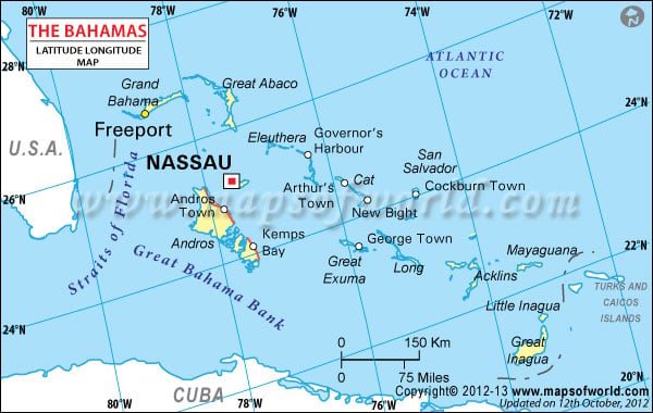
Bahamas Latitude and Longitude Map USA Lat Long Map Cuba Lat Long Map Turks Caicos Islands Lat Long Map
Description : Find Bahamas latitude and longitude map showing comprehensive details including cities, roads, towns, airports and much more. Disclaimer
×

Disclaimer  :  All efforts have been made to make this image accurate. However MapSherpa, Inc, its directors and employees do not own any responsibility for the correctness or authenticity of the same.


Search For Latitude & Longitude Map

By Country

Or

Latitude

Longitude

Or

Area

* Put South & West values with minus ( - ) sign.


Bahamas is situated in between 24° 15' The geographical coordinates are 76° 0' west and 24° 15' north. The Bahamas latitude and longitude means that it is a part of the Caribbean Islands group. The North American nation is situated on the shores of the Atlantic Ocean.

Borders of Bahamas
Bahamas are bordered in their south by Cuba, Haiti and Dominican Republic and in the southeast by Turks and Caicos Islands. The United States of America lies to the northwest of the Caribbean nation.

Bahamas Cities Latitude and Longitude
Following are the latitudinal and longitudinal details of some of the top cities of Bahamas:


LocationLatitudeLongitude
Nassau77° 20 W25° 05'N
Matthew Town73° 40'W20° 57N
Freeport78° 47'W26° 30'N
Bimini Islands79° 25'W25° 42'N
Adelaide77° 31'W25° 04'N
Adelaide25°04'N77°31'W
Albert Town22°37'N74°33'W
Andros I.,24°30'N78°00'W
Andros Town24°43'N77°47'W
Arthur's Town24°38'N75°42'W
Berry Is.25°40'N77°50'W
Bimini Is.25°42'N79°25'W
Cat I.24°30'N75°30'W
Cay Sal Bank23°45'N80°00'W
ClarenceTown23°06'N74°59'W
Conception I.23°52'N75°09'W
Crooked I.22°50'N74°10'W
Crooked Island Passage23°00'N74°30'W
Duncan Town22°15'N75°45'W
Dunmore Town25°30'N76°39'W
Eleuthera25°00'N76°20'W
Exuma Sound24°30'N76°20'W
Freeport26°30'N78°47'W
George Town23°33'N75°47'W
Governor's Harbour25°10'N76°14'W
Grand Bahama26°40'N78°30'W
Great Abaco I.26°25'N77°10'W
Great Bahama Bank23°15'N78°00'W
 
LocationLatitudeLongitude
Great Exuma I.23°30'N75°50'W
Great Guana Cay24°00'N76°20'W
Great Inagua I.21°00'N73°20'W
Guanahani/San Salvador I.24°00'N74°40'W
Hogsty Reef21°41'N73°48'W
Hope Town26°35'N76°57'W
Jumentos Cays23°00'N75°40'W
Little Abaco I.26°50'N77°30'W
Little Inagual I.,21°40'N7°.50'W
Long I.23°20'N75°10'W
Matthew Town20°57M73°40'W
Mayaguana22°30'N72°44'W
Mira por vos cay22°09'N74°30'W
Nassau25°05'N77°20'W
New Providence 25°25'N78°35'W
Nicolls Town25°08'N78°0'W
Plana Cays22°38'N73°30'W
Rock Sound24°54'N76°12'W
Rosa L. 21°0'N73°30'W
Rum Cay 23°40'N74°58'W
Samana Cay23°3'N73°45'W
San Salvador I. 24°0'N74°40'W
Sandy Cay23°13'N75°18'W
Santa Domingo Cay.21°25'N75°15'W
Settlement Pt. 26°40'N79°0'W
Snug Corner22°33'N73°52'W
West End26°41'N78°58'W

Last Updated on: May 26th, 2023