- Jordan Cities - Amman
- Neighboring Countries - Israel, Lebanon, Syria, Iraq, Saudi Arabia
- Continent And Regions - Asia Map
- Other Jordan Maps - Jordan Map, Where is Jordan, Jordan Blank Map, Jordan Road Map, Jordan Rail Map, Jordan River Map, Jordan Physical Map, Jordan Flag
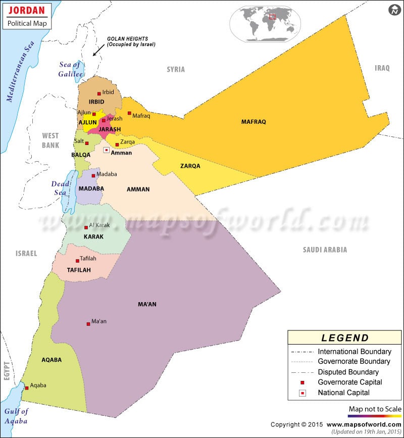
The Hashemite Kingdom of Jordan is a country located in the Middle East, bordering Saudi Arabia, Iraq, Syria, and Israel. Jordan is situated along the East Bank of the River Jordan and the Dead Sea. The capital and largest city of Jordan is Amman.
Jordan is made up of twelve governorates (provinces), and further divided into 54 nahais (districts). Each of the governorates is headquartered in a capital, most of which share the same name as their governorate. The only governorates that have a capital with a different name are Balqa, which is headquartered in Salt, and Karak, for which the capital is called Al Karak. The governorates are divided into three geographic regions, the North Region, Central Region, and South Region.
The largest provinces by area are Ma’an, Mafraq, and Amman. The largest by population are Amman, which holds the national capital and largest city, and is home to over 2.2 million people, followed by Irbid, Zarqa, and Balqa.
| Province | Pop-2004 | Pop-1994 | Area(km.²) | Area(mi.²) |
|---|---|---|---|---|
| Ajlun | 118,725 | 94,548 | 412 | 159 |
| Amman | 1,942,066 | 1,576,238 | 8,231 | 3,178 |
| Aqaba | 102,097 | 79,839 | 6,583 | 2,542 |
| Balqa | 346,354 | 276,082 | 1,076 | 415 |
| Irbid | 928,292 | 751,634 | 1,621 | 626 |
| Jarash | 153,602 | 123,190 | 402 | 155 |
| Karak | 204,185 | 169,770 | 3,217 | 1,242 |
| Ma`an | 94,253 | 79,670 | 33,163 | 12,804 |
| Madaba | 129,960 | 107,321 | 2,008 | 775 |
| Mafraq | 244,188 | 178,914 | 26,435 | 10,207 |
| Tafilah | 75,267 | 62,783 | 2,114 | 816 |
| Zarqa | 764,650 | 639,469 | 4,080 | 1,575 |
| 12 provinces | 5,103,639 | 4,139,458 | 89,342 | 34,494 |

 Facts about Jordan