- Neighboring Countries - Slovakia, Austria, Romania, Croatia, Serbia
- Continent And Regions - Europe Map
- Other Hungary Maps - Hungary Map, Where is Hungary, Hungary Blank Map, Hungary Road Map, Hungary Rail Map, Hungary River Map, Hungary Cities Map, Hungary Physical Map, Hungary Flag
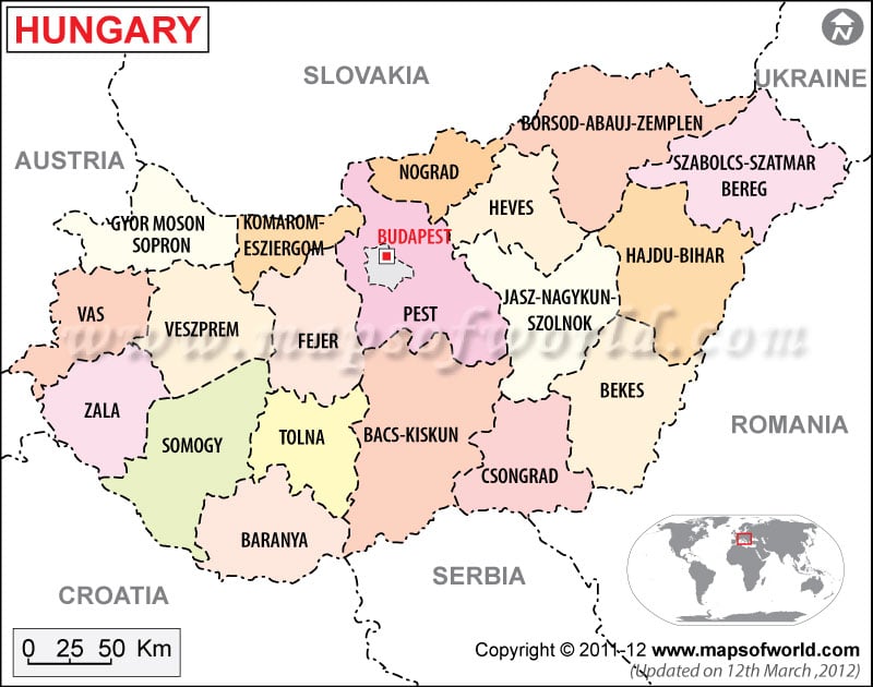
Hungary political map features all details of a political map. The map of Hungary marks the international boundary with a black bold line and a violet line to differentiate the counties.
The bordering countries are also marked on the country map of Hungary. The county capitals are marked with green squares and the red star on the online Hungary political map denotes the country capital.
Hungary political map features the international boundary, the county boundaries with their capitals, national capital and other important cities. The international boundary of the country is marked with a black bold line. The bordering countries are also mentioned in the map. Croatia, Serbia and Montenegro, Slovenia, Romania, Ukraine, Slovakia and Austria are the bordering countries marked in the online political map of Hungary. The county boundaries are marked with a violet line differentiating from each other.
Geography and Location
The country of Hungary is located in the northwestern part of Romania in Central Europe. The country is located at 47° 00′ North latitude and 20° 00′ East longitude. The total area of the country is 93, 030 square kilometers, of which the land area covered is 92, 340 square kilometers and the rest 690 square kilometer is covered by water bodies. Hungary is a landlocked country. The highest point of the country is at Kekes situated 1,014 meters above sea level. The lowest point is at Tisza River flowing 78 meters above sea level.
County Boundaries and Capitals
The county capitals can be easily pointed out, which are marked by green squares. The county boundaries are marked with a violet line differentiating from each other. There are 19 counties in the country. The counties with their capitals are mentioned below:
- Bacs-Kiskun: Kecskemet
- Hajdu-Bihar: Debrecen
- Bekes: Bekescsaba
- Borsod-Abaej-Zemplen: Miskolc
- Fejer: Szekesfeherver
- Baranya: Pecs
- Gyor-Moson-Sopron: Gyor
- Nograd: Salgotarjan
- Szabolcs-Szatmar-Bereg: Nyiregyhaza
- Csongred: Szeged
- Vas: Szombathely
- Heves: Eger
- Jasz-Nagykun-Szolnok: Szolnok
- Veszprem: Veszprem
- Komarom-Esztergom: Tatabanya
- Zala: Zalaegerszeg
- Pest: Budapest
- Somogy: Kaposvar
- Tolna: Szekszard
Capital of Hungary
The country capital of Hungary is Budapest and is marked with a red star on the printable map of Hungary. The geographical coordinates of the city are 47° 30′ North latitude and 19° 4′ 60” East longitude. The capital city is situated at a height of 102 meters above sea level. The nearby cities are Gellerthegy, Taban, Angyalfold, Zuglo, Ferencvaros, Erzsebetvaros and Var. The main airports of the city are Ferihegy, Kecskemet and Csakvar.
| Division | Population | Area(km.²) | Area(mi.²) | Capital or county |
|---|---|---|---|---|
| Bacs-Kiskun | 438,768 | 8,124 | 3,137 | Kecskemet |
| Baranya | 244,950 | 4,267 | 1,647 | Pecs |
| Bekes | 329,823 | 5,437 | 2,099 | Bekescsaba |
| Bekescsaba | 67,968 | 194 | 75 | (Bekes) |
| Borsod-AbaUj-Zemplen | 560,279 | 7,010 | 2,707 | Miskolc |
| Budapest | 1,777,921 | 525 | 203 | Budapest |
| Csongrad | 215,689 | 3,499 | 1,351 | Szeged |
| Debrecen | 211,034 | 461 | 178 | (Hajdu-Bihar) |
| Dunaujvaros | 55,309 | 53 | 20 | (Fejer) |
| Eger | 58,331 | 105 | 40 | (Heves) |
| erd | 56,567 | (Pest) | ||
| Fejer | 272,662 | 4,135 | 1,597 | Szekesfehervar |
| Gyor | 129,412 | 175 | 67 | (Gyor-Moson-Sopron) |
| Gyor-Moson-Sopron | 249,119 | 3,745 | 1,446 | Gyor |
| Hajdu-Bihar | 341,964 | 5,749 | 2,220 | Debrecen |
| Heves | 267,396 | 3,533 | 1,364 | Eger |
| Hodmezovasarhely | 49,382 | 483 | 187 | (Csongrad) |
| Jasz-Nagykun-Szolnok | 338,286 | 5,394 | 2,083 | Szolnok |
| Kaposvar | 68,697 | 114 | 44 | (Somogy) |
| Kecskemet | 107,749 | 321 | 124 | (Bacs-Kiskun) |
| Komarom-Esztergom | 244,120 | 2,174 | 839 | Tatabanya |
| Miskolc | 184,125 | 237 | 91 | (Borsod-Abauj-Zemplen) |
| Nagykanizsa | 52,106 | 148 | 57 | (Zala) |
| Nograd | 175,297 | 2,441 | 943 | Salgotarjan |
| Nyiregyhaza | 118,795 | 274 | 106 | (Szabolcs-Szatmar-Bereg) |
| Pecs | 162,498 | 163 | 63 | (Baranya) |
| Pest | 1,027,310 | 6,394 | 2,469 | Budapest |
| Salgotarjan | 44,964 | 103 | 40 | (Nograd) |
| Somogy | 266,540 | 5,922 | 2,287 | Kaposvar |
| Sopron | 56,175 | 169 | 65 | (Gyor-Moson-Sopron) |
| Szabolcs-Szatmar-Bereg | 463,461 | 5,661 | 2,186 | Nyiregyhaza |
| Szeged | 168,273 | 281 | 108 | (Csongrad) |
| Szekesfehervar | 106,346 | 171 | 66 | (Fejer) |
| Szekszard | 36,229 | 96 | 37 | (Tolna) |
| Szolnok | 77,631 | 187 | 72 | (Jasz-Nagykun-Szolnok) |
| Szombathely | 81,920 | 98 | 38 | (Vas) |
| Tatabanya | 72,470 | 91 | 35 | (Komarom-Esztergom) |
| Tolna | 213,454 | 3,607 | 1,393 | Szekszard |
| Vas | 186,203 | 3,239 | 1,250 | Szombathely |
| Veszprem | 310,943 | 4,486 | 1,732 | Veszprem |
| Veszprem | 62,851 | 127 | 49 | (Veszprem) |
| Zala | 183,644 | 3,536 | 1,365 | Zalaegerszeg |
| Zalaegerszeg | 61,654 | 100 | 39 | (Zala) |
| 43 divisions | 10,198,315 | 93,029 | 35,919 |
