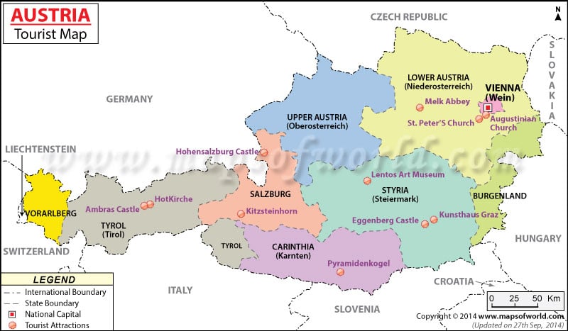
Locations in the Map
Major Locations:
Niederosterreich, Sankt Polten, Vienna, Wein, Eissenstadt, Burgenland, Graz, Steiermark, Oberosterreich, Linz, Salzburg, Innsbruck Tirol, Bregenz, Vorarlberg, Liechtenstein, Ost Tirol, Karnten, Klagenfurt.
Major Cities:
Villach, Wolfsberg, Deutschlandsberg, Frieasach, Furstenfield, Hartberg, Koflach, Judenburg, Knittelfeld, Tamsweg, Mittersill, Landeck, Imst, Bludenz, Feldkrich, Worgol, Kufstein, Bad Aussee, Liezen, Elsenerz, Muzzuschlag, Wiener Neustad, Ybbs, Gmunden, Steyn, Enns, Wels, Ried, Braunau, Scharding, Freistadt, Horn, Krems, Stockerau, Hollabrunn, Gmund.
Tourist Places:
Zwetti, Sankt Polten, Vienna, Eisenstadt, Graz, Leoben, Murau, Zeli am See, Kitzbuhel, Innsbruck, St. Anton, Voralberg, Bregenz, Salzkammergut, Werfern, Salzburg, Linz, Leinz, Klagenfurt.
Neighbour Countries:
This landlocked country shares its borders with the Czech Republic and Germany to the north, Slovakia and Hungary to the east, Slovenia and Italy to the south, and Switzerland and Liechtenstein to the west.
